The Karakorams are a large mountain range that span the borders of Pakistan, China and India. It is the second highest mountain range in the world and home to K2, the second tallest mountain in the world.
Below is a guide to the Karakoram Mountain Range, including information on notable mountains and hikes within the range.
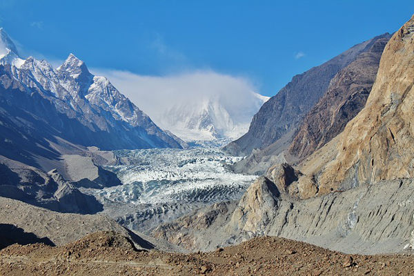
The Karakoram Mountains
Length: 500km
Geology
The mountains in Asia originated from folding in the Cenozoic Era. Granites, gneisses, crystallised schists and phyllites dominate the geological structure. At the end of the Mesozoic Era, the region was characterised by great structural changes.
The Karakoram emerged as a result of intensive geologically recent upheaval. The range is still experiencing frequent seismic activity. Some events are so violent they often trigger massive rock and ice avalanches.
Topography
The range runs from east to west. It is characterised by deep narrow valleys, sharp peaks, glaciers and rivers. The average height of the mountain range is 6000m above sea-level. The range is home to four of the world’s 14 peaks exceeding 8,000m above sea-level.
Karakoram is the most heavily glaciated part of the world outside the polar regions with 28-50% of the area covered by glaciers. The Siachen Glacier (76km) and the Biafo Glacier are the world’s second and third largest glaciers outside the polar regions with the Sachen Glacier being the most famous.
There are a total of 7 passes within the mountain range, Khunjerab is the most famous. The Karakoram Highway, a 1,300km long road connecting Pakistan and China is a popular tourist attraction.
Climate
The climate of Korakoram is semi-arid and severe. The southern slopes are exposed to the moist monsoon winds coming from the Indian Ocean, while the northern slopes are extremely dry.
The lower and middle slopes receive rain and snow in very small quantities. At elevations of 4,900m and above precipitation is always in solid form. At heights of 5,700m, the average temperature in the warmest month is lower than 0 degrees Celsius and at heights of 3,900m-5,700m the average temperature is lower than 10 degrees Celsius.
Rarefied air, intensive solar radiation, strong winds and great diurnal ranges of temperature are characteristic climatic features of the Karakoram Mountain Range.
Wildlife and Plants
At the lower valleys, all profuse vegetation is anthropogenic. The rocky and arid lower slopes only support discontinuous grazing areas.
Extensive undulating pastures intersperses the high peaks.
The Karakoram have upper and lower treelines, the upper delimited by cold and the lower by aridity. In these lines is only degraded, sparse tree cover. Willow, poplar and oleander thickets occur along water courses up to 3,000m.
Juniper can be found on high slopes among seasonal snowfields.
Shrubs of the genus Artemisia provide sparse cover on the lower slopes.
Hunting as taken a severe toll on the mountain wildlife in the Karakoram. Marco Polo sheep now only breed in the eastern Pamirs and migrate west.
Ladakh urials inhabit the high, flatter mountains to the east and Siberian ibex and markhors negotiate the craggy slopes.
Brown bears, lynx and snow leopards are amongst the endangered species. Wild yak and large raptors can also be found in the mountain range.
Mountain Regions in the Karakoram
Here is a list of the subranges that lie within the Karakoram Mountains. The list runs from west to east and includes some of the world's tallest mountains.
Batura Muztagh

Photo by Ali Usman Baig
This is the westernmost subrange. It is home to Muchu Chhish, the second highest unclimbed peak in the world.
Rakaposhi-Haramosh

Photo by Muhammad Afzal
Located in the Gilgit-Baltistan province of Pakistan.
Spantik-Sosbun Mountains

Photo by RasheedFR
This narrow range also falls into Gilgit-Baltistan.
Hispar Muztagh

Photo by Feng Wei
This is the second highest sub-range in the Karakorams.
South Ghujerab Mountains

Located in the northern areas of Pakistan.
Baltoro Muztagh

Photo by Rizwan Saddique
Highest sub-range and home to K2 as well as 3 other eight-thousanders. Its crest forms part of the China-Pakistan border.
Saltoro Mountains

Photo by Rizwan Saddique
Lies on the southwest side of the Siachen Glacier.
Siachen Muztagh

Photo by Rizwan Saddique
This remote range is 60% controlled by China and 40% by India.
Rimo Muztagh

This is one of the most remote sub-ranges.
Saser Muztagh

Photo by Amit Rawat
This is the easternmost subrange, in the Ladakh region of India.
Notable Mountains in the Karakorom
Karakoram is the second highest mountain range in the world and is home to four of the world’s 14 peaks over 8,000m above sea level. It is also home to K2, the second highest peak in the world, after Mount Everest.
The mountain range has 8 summits over 7,500m above sea level and 4 mountains exceeding 8,000m above sea level. Below is information on the most notable mountains in the range.
K2

K2 is one of the eight thousanders. Also known as Mount Godwin-Austen or Chhogori, is the second highest peak in the world and stands at an impressive 8,611m above sea-level.
It is located on the China-Pakistan border. It is known as the “Savage Mountain,” due to its extremely difficult ascent. It is considered the world’s most dangerous mountain with 300 successful summits and 77 fatalities.
It was first summited in 1954 and has never been summited during winter.
Gasherbrum I

Photo by Szilvia Pal
This mountain was surveyed as K5 and is also known as the Hidden Peak. It is the 11th highest mountain in the world and forms part of the Gasherbrum Massif. It stands at 8,080m above sea-level and is located on the China-Pakistan border.
It was first summited in 1958.
Broad Peak

Photo by Brad
At 8,047m above sea-level, Broad peak is the 12th highest mountain in the world. It forms part of the Gasherbrum Massif and is about 8km away from K2.
Its first ascent was in 1957, but the first ascent in winter was only in 2013.
Gasherbrum II

Photo by CEM Capafonts
Gasherbrum II, surveryed as K4, is the world’s 13th highest mountain and the third highest peak in the Gasherbrum Massif. It stands at 8,035m above sea-level, making it the shortest of the eight-thousanders in the Karakoram Mountains.
The first ascent was in 1956.
Gasherbrum III

Photo by Mark Horrell
Gasherbrum III, surveyed as K3a, is at 7,952m above sea-level, just short of being an eight-thousander, but it is still an impressive peak nonetheless. It also forms part of the Gasherbrum Massif and lies between Gasherbrum II and Gasherbrum IV.
It was once one of the highest unclimbed summits in the world until the first ascent in 1975.
Notable Hikes in the Karakorom
Hiking the Karakorams is a life altering experience. But you need to be well-prepared in order to make your journey as easy as possible, make sure you have the right clothing and equipment for the trek you are going to embark upon.
You will most likely be camping on your treks, with a few nights at hotels at the beginning and end of the trek.
A guide is recommended, and there are many tour agencies offering guided treks.
Mountaineering season falls within the summer months of June-September with July and August being the most popular. You will definitely want to avoid the harsh weather and heavy snows of the winter months which would make your trek more dangerous.
Below is a list of notable hikes/treks in the Karakorams.
K2 Base Camp Trek

Photo by Rizwan Saddique
The trek to the K2 Base Camp is considered to be one of the world’s greatest treks with its breathtaking scenery and view of some of the world’s highest peaks. The trek should take between 9-15 days and you can expect to be trekking for around 5-7 hours a day.
You will trek up the mighty Baltoro Glacier and take in the incredible views of the great peaks of the Karakorams.
Although this isn’t the K2 summit, the trek is still very challenging, and you should be prepared and physically fit.
Experience one of the most spectacular treks in the world with the K2 Base Camp Trek.
Snow Lake and Hispar La Trek

Photo by Feng Wei
The Snow Lake is a high-altitude basin which is over 16km wide and is located at the head of the Biafo and Hispar Glaciers. The trek crosses the two glaciers end-to-end, this is the longest glacial system within the Karakorams at 116km long.
Where the glaciers meet lies the Snow Lake, which is encircled by unnamed and unexplored peaks.
You will have the privilege of trekking in a truly remote and stunning area. The trek is considered by some to be one of the most beautiful treks in the world. You will trek past stark mountains, icy white glaciers and gorgeous flower-filled meadows.
Although beautiful, the 15-day trek is strenuous, and you will need to be physically fit in order to complete the journey.
Your accommodation will be a combination of camping and hostels.
Thalay La/Masherbrum Base Camp Trek

Photo by Rizwan Saddique
This easy trek is one of the most popular short treks in the Baltisan region. The 11 day-trek is ideal for those interested in exploring the life of highlanders in Baltisan and truly experiencing Balti culture.
The trek is around 11-days long and meanders through Khaplu and Shiger Valleys. You will see the beautiful fruit orchards and lush green glory of full alpine flowers in the summer.
The trek takes you through varied landscapes; from the sands of the Indus Valley to the high snows of spectacular peaks.
The Great Karakoram Traverse Trek

This expedition is a combination of two of the world’s most interesting and beautiful treks; Condogoro Glacier and the Panoramic Trek which go through Snow Lake and Hisper La. You will traverse two of Karakoram’s main passes and be treated to incredible views of the immense mountains and bountiful glaciers of the range.
The expedition can last up to 33 days with 26 nights camping and 6 nights spent in a hotel.
The trek is certainly strenuous and is only recommended for good, experienced trekkers.
References: Britannica, Wikipedia, Lonely Planet, National Geographic

Saser Muztagh – how can this be done? details ? any info leading to it please.
is there any K4 facts that aren't specified here i'm researching it for a essay and cant find much info on it
Do you mean K2 or K4 (i.e. Gasherbrum II)? There are tonnes of facts online about both mountains.
yes. check it out wth google.