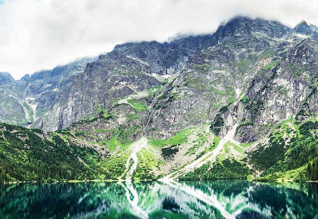
The Carpathian Mountains is the third longest mountain range in Europe and runs through half a dozen countries.
With unique plant, wildlife and hiking experiences, visiting the mountain range is a once in a lifetime experience.
Below is all the important information on the mountain range including the notable mountains and hikes for you to enjoy.
The Carpathian Mountains
Length: 1500km (3rd longest in Europe)
Geology - How Old Are Carpathian Mountains?
Part of the mountains consists of volcanic rocks formed about 50 million years ago.
The area was once occupied by smaller ocean basins. The mountain range was formed during the Alpine Orogeny in the Mesozoic and Tertiary by the ALCAPA, Tisza and Dacia plates moving over sub-ducting oceanic crust.
The mountains take the form of a fold and thrust belt with generally north vergence in the western segment, northeast to east vergence in the eastern portion and southeast vergence in the southern portion.
Topography
The Carpathian Mountains stretch 1500 km, making it the third longest mountain range in Europe. The range runs through the countries of the Czech Republic, Slovakia, Poland, Hungary and Romania (see hikes in Romania), which is home to the largest percentage of the mountain range. The mountains form a natural border between Slovakia and southern Poland.
There are a number of important mountain passes, particularly in Romania, and the mountain range is the source of the Dniester, Tisza and Vistula Rivers.
Climate
The climate of the Carpathian Mountains is governed by the inflow of polar-continental air masses arriving from east and northeast in winter, with oceanic air masses from the west predominating in other seasons.
The distance from the Atlantic Ocean and the influence of intervening air masses of the Alps and Bohemian Massif caused diminished precipitation, making the range fairly dry.
The mean annual and monthly air temperatures vary according to altitude above sea-level.
Wildlife and Plants
Different vegetation in the Carpathians is distinguished by the various altitudinal zones. The alpine stage is characterized by high mountain pastures. At the subalpine stage you will find dwarf pine growth.
At the upper forest stage, you will find spruce as well as pastoral use for economic land use. The lower forest stage is known for its beech forests as well as oat and potato farms. The foreland stage is peppered by oaks and elms as well as wheat and potato fields.
The Carpathian Mountains are home to many unique plant species, especially in the south eastern parts of the mountain range. The forests are best preserved in the east.
The mountain range is home to the largest European populations of brown bears, wolves, chamois and lynxes. You can also find deer, boars and marmots.
Carpathian Mountain Regions
Eastern Carpathians

South-eastern Poland, eastern Slovakia, Ukraine, Romania
Southern Carpathians

Serbia and Romania.
Western Carpathians

Austria, Czech Republic, Poland, Slovakia, Hungary.
Smaller Mountain Regions
- Beskids: Mountain range in Poland, part of the Carpathian Mountains. Border of Czech Republic in the west and Bieszczady in the west.
- High Tatras: Mountain range in Tatra National Park in Slovakia.
- Low Tatra: Central part of Slovakia.
- Gorce: Mountain range in Poland, part of the Carpathian Mountains. North west Pieniny.
- Pieniny: South of Poland, north east of Tatra Mountains.
- Bieszczady: Polish part of the Carpathians.
Notable Carpathian Mountains
The Carpathian Mountains aren’t a particularly high mountain range as the maximum height in the range is only 2,655 m above sea-level. So this range certainly isn’t any competition for some of the more prominent mountain ranges around the world.
The range has 28 peaks exceeding 2,500 m above sea-level, most of these reside in the High Tatras of Slovakia.
Here is a list of the highest mountains in the Carpathian Mountain Range:
Gerlachovsky stit
At 2,655 m above sea-level, this is the highest peak in the Carpathian Mountains, as well as the highest peak in the High Tatras in Slovakia. Its pyramidal shape attracts numerous visitors despite authorities trying to place stricter restrictions on the mountain.
The mountain’s first recorded ascent was in 1834.
Gerlachovska veza

Gerlachovska veza is 2,642 m above sea-level, making it the second highest mountain in the Carpathians. It is located in the Northern ridge of Zadni Gerlach in the main ridge of the Slovak High Tatras.
Its first recorded ascent was in 1905.
Lomnicky stit

Lomnicky stit is one of the highest and most visited mountain peaks in the High Tatras Mountains of Slovakia. It is the third highest peak in the Carpathian Mountains.
You can travel up to the peak by cable car and you are permitted to spend 50 minutes on the mountain.
The first recorded ascent was in 1793 and the first winter ascent was recorded in 1891.
L’adovy stit

This mountain is the 4th highest in the High Tatra Mountains in Slovakia as well as the Carpathians and northern and eastern Europe as a whole.
It stands at 2,627 m above sea-level and was first summited in 1843.
Notable Hikes in the Carpathians
Although Carpathian Mountains offer some of the unforgettable hiking opportunities in Europe, it is a truly off-the-beaten-path hiking experience.
Accommodation available to hikers varies from hike-to-hike and country-to-country, but you are most likely to encounter rustic huts, camp sites, basic hostels and some rather simple chalets.
As often with European hikes, a guide is not always required. However, on some trails, it is actually illegal to hike independently. So please make sure you are well aware of the rules and requirements of guided hikes before booking your trip. Most operators don't charge a lot for a trek, so it might be worth considering booking a hike anyway.
The best time to visit the Carpathian Mountains is completely subjective and dependent on what you are looking for personally. Whether you are looking for the snow-coverage of winter or the wild flowers of spring, when you choose to go is completely up to you.
Transylvania Mountain Trail

80-130 km long, the Transylvania Mountain Trail takes about 7-10 days to complete, takes you to see the notorious Bran Castle suspended on a rocky cliff. This castle is most famously associated with Dracula.
The route takes you over three of Romania’s highest peaks and you will be able to visit medieval towns called Sighisoara as well as the opportunity to see monasteries, fortified Saxon churches and local churches.
The trail is moderately difficult, and a good level of physical fitness is required. The accommodation is fairly basic, so remember to pack your own sleeping bag.
Gerlachovsky Stit Summit
With its height and breathtaking scenery, summiting Gerlachovsky stit is an amazing opportunity. It is one of Slovakia’s most visited and challenging peaks!
It should take you between 8-10 hours to reach its summit, but a guide is highly recommended, in fact, it would be crazy to attempt the hike without one. There are two routes to the summit designed for tourists.
Once at the top, you will be treated to incredible views overlooking Slovakia on the south side and Poland on the north side.
This is a challenging hike and it is important you are prepared physically as well as having the correct gear in order to reach the top. Suitable clothing and hiking boots are an absolute necessity.
Mount Hoverla Summit

At 2,016 m above sea level, Mount Hoverla is Ukraine’s highest peak. Mount Hoverla isn’t a particularly difficult mountain to hike and you will be greeted with vibrant plant life, incredible wild flowers and indigenous wild life.
The hike is a 6-8 hour round trip and you will enjoy a spectacular 360-degree view from the top. The mountain is notorious for bad weather out of season, so make sure to visit in the months of July and August when the weather is at its best.
The Retezat National Park

The Retezat National Park in Romania is a hikers’ dreamland and perfect for wilderness enthusiasts.
With 20 peaks exceeding 2,000 m above sea-level, hiking here is a one of a kind experience. Trails here are bordered by over 80 glacial lakes, including the largest and deepest glacial lakes in Romania.
It is Romania’s first national park and a UNESCO Reserve. It is home to some of the best-preserved wild areas in the Carpathian Mountains.
Its highest peak, Peleaga, offers incredible views from its peak. The park is known as the “blue eye land” due to its bountiful glacial lakes.
With 1,200 species of plants and 55 mammals, you will have ample opportunity to immerse yourself in nature. If you enjoy bird-watching, hiking here is ideal for you.
References: Britannica, Wikipedia, Lonely Planet


Hi Mark,
Thanks for the article!
For the Transylvanian Mountain Trail (80-130km/7-10 days), do you have any further information and/or a rough plan or itinerary with locations, timeframes and transport?
Many thanks,
P