The Alta Via 1 is the most popular of all the ‘high routes’ in the Dolomites. Of all the Alta via trails, hiking Alta Via 1 is the easiest option. This is the busiest of the long-distance hiking trails in Italy.
Highlights on Alta Via 1 include Passo Falzarego and the famous Galleria Lagazuoi, tunnels used during World War 1.
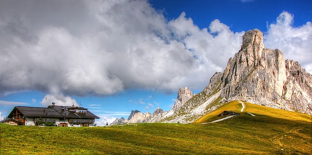
Most of the route is straightforward but there are some optional sections where you can navigate the mountainside on via ferrata. The trail includes all the features that make hiking the Dolomites great - alpine meadows, pine forests, and limestone rock formations.
In this article, I go through everything you need to know when planning your Alta Via 1 trek. I’ve also broken down the route in some detail including your options for rifugios on Alta Via 1.
Hiking The Dolomites, Alta Via 1
Where Does Alta Via 1 start and end?
The Alta Via 1 is a long-distance hiking trail that traverses the Italian Dolomites. The trail begins at Lago De Braies, close to the town of Dobbiaco.
The closest airport to the trailhead is Venice. From there you can catch a bus to Cortina and either stay over in this town or take another bus to Dobbiaco.
The trail ends in Belluno, a city in the Veneto region of Italy. The trail ends at a bus stop making it easy to catch a 20-minute ride to Belluno.
Alta Via 1 Difficulty - How Fit Do You Need To Be?
The total distance of the route is around 120 kilometers (75 miles). It typically takes hikers around 10-11 days to complete the entire trail but you could extend this by a few more. When compared to the other high routes (or Alta Vias), this is the easiest.
There are no technical climbs or glacial crossings. There are a few via ferrata sections, i.e. cables down steep rock. These are optional and can be avoided through alternative routes.
If you plan on doing this hike, whether unguided or with a tour, you need to be able to hike for 5-8hrs a day. If you exercise regularly and have done some other hikes in Europe, you should be okay.
Many sections of the trail reach altitudes of over 2,000 meters (6,500 feet). You can expect challenging terrain with a few steep ascents and descents, rocky paths, and exposed ridges. Trekking poles will come in handy on this trail.
The better your fitness, the more you are going to enjoy the hike itself.
When Is The Best Time To Hike Alta Via 1?

The trail has a short hiking season from about mid-June to mid-September. These are the summer months when trekking conditions are clear and sunny.
The huts are only open between the third week of June to the third week of September. This means that there is no accommodation option to hike out of season.
Even during the ‘good months’ you should be prepared to encounter afternoon storms. Light snow is also a possibility, particularly in June.
Alta Via 1 Rifugios
What To Expect When Staying at An Italian Rifugio
Rifugios are mountain huts that have been established to offer accommodation to trekkers in the European mountains. These establishments are not super fancy. Most are hard to access by road and are built out of wood. They do however offer a warm place to sleep, meals, and basic showers.
Most rifugios have options for booking a private room as well as staying in a dorm.
Rifugios are run by local families. Good hospitality and delicious local cuisine at the rifugios are some highlights of the Alta Via 1. They are also a great place to meet fellow trekkers and make new friends.
Each rifugio offers basic accommodation, meals, and supplies such as snacks, drinks, and hiking maps. It's important to note that most rifugios operate on a cash-only basis, bring plenty of euros with you on the trail.
Popular Rifugios, Alta Via 1
Below are some of the most popular Alta Via 1 Rifugios. Where possible, I’ve included prices and/or useful info.
- Rifugio Biella: Usually the first stop on the Alta Via 1 trek. Facilities are a bit basic but the food is good
- Rifugio Pederu: €61-65pp for a private room. Breakfast included
- Rifugio Sennes: This rifugio is located at an altitude of 2,116 meters (6,942 feet). It costs around €40pp for a private room
- Rifugio Fanes: Located in the heart of the Fanes-Sennes-Braies Nature Park, on the meadows of Kleinfanes. Some tour companies use this as the first stop on the Via 1trek. Price: €38pp for a private room
- Rifugio Lagazuoi: At an altitude of 2,752 meters (9,029 feet), this is the highest point up the AV1 Trail. It's also home to a World War I museum, which is well worth a visit. Price: about €90 for a private room
- Rifugio Nuvolau: One of the oldest rifugios dating back to 1883and offers panoramic views of the surrounding mountains. With 360 degree views, it's a popular spot for hikers to watch the sunset.Price: €65pp for shared room (4 people)
- Rifugio Citta di Fiume: This rifugio is located at an altitude of 1,911 meters (6,270 feet. It has only the most basic facilities.
- Rifugio Passo Staulanza: Probably the nicest Rifugio on the trail. If you want to treat yourself, you can book a double room with an on-suite bathroom (€80 pp). The rooms hold up against decent hotels. Also, the hot chocolate here is worth staying for!
- Rifugio Coldai: 7km 2-3 hrs from Rifugio Passo Staulanza
- Rifugio Tissi: €60pp for a shared room (4 people)
- Rifugio Vazzoler: An alternative to Rifugio Tissi. Some people complain that this Rifugio is a little cold. However, the hosts are fantastic and really make the effort to make hikers feel welcome. There is also an amazing view of Monte Civetta.
- Rifugio Carestiato: This rifugio is located at an altitude of 1,829 meters (6,001 feet) . Some people stay here instead of Paso Duran.
- Rifugio Paso Duran: Basic and usually quieter than Rifugio Carestiato (about two kilometers further). Great views of Cima Nord San Sebastiano. €42pp for a shared room (4 people).
- Rifugio Pian De Fontana: These were shepherds' huts which have been converted to bunkhouses. €53pp to stay in a dorm. Hot showers cost extra.
Can I Hike Alta Via Numero 1 Without A Guide?

Hiking the Alta Vista 1 Trail, Italy (Image by: Simonsimages on flickr)
The Alta Via 1 trek is a straightforward route that is easy to do without a guided tour. The trail is almost always busy. If you have any doubts about direction, you can follow other hikers.
The rifugios also sell meals so you will not have to bring food with you. Even so, it’s good to pack plenty of snacks as there are some long sections between huts.
Before your hike, you can buy a detailed map in the towns of Cortina d'Ampezzo and in Dobbiaco. If you are looking for a good Alta Via One Guidebook, we recommend , which has a separate map booklet.
If you are hiking independently, I’d suggest securing your accommodation ahead of time. Most of the Rifugios have an online booking site, or at least a phone number, through which you can make reservations.
Alta Via 1 Route

Below is an outline of the Alta Vista 1 Trail. I’ve briefly described the Alta Via 1 itinerary for hiking each day.
There are some variations including optional pathways and detours which will affect the exact length of your hike.
Day 1: Lago de Braies to Rifugio Biella
On this first part of the trail there is a fairly steep ascent all the way to the hut. If you have the energy, there is the option to climb Croda Del Bocca (2,810m / 9,219 ft) which will give you some nice wide views of the landscape.
- Distance: 7.5km/ 4.7 miles
- Hiking time: 3-4 hrs
Day 2: Rifugio Biella - Rifugio Fanes
From Rifugio Biella, the trail descends and passes Refugio Pederu before rising again. You have the choice to stay at Refugio Lavarella or Rifugio Fanes.
- Distance: 12km/ 7.5 miles
- Hiking time: 5-6 hrs
- Note: Often day one and day two are combined and hikers spend the first night at Rifugio Fanes. This is a 20km first-day hike.
Day 3: Rifugio Fanes - Rifugio Lagouzuoi
This part of the hike is one of the best as you trek through the Cortina d' Ampezzo Valley. You will climb up the Forcella Del Lago pass. After this it is a steep trek down to the viewpoint at Lago di Lagazuoi.
Once down, it is a tough climb up Mount Lagazuoi, the highest point of the Alta Via trail. This is where you will find Rifugio Lagazuoi. The total elevation gain for this section of the hike is 1150m
- Distance: 12km/ 7.5 miles
- Hiking time: 5-6 hrs
Day 4- Rifugio Lagauoi - Rifugio Nuvolau
From Lagouzuoi, you have the option to go through the Lagouzuoi tunnels (Galleria Lagouzuoi). These are restored tunnels originally built by italian troops in WW1 to sneak up on Austrian forces. There is a via ferrata system in the tunnels for you to descend safely, you will need a headlight to see where you are going.
You cross briefly in the valley before climbing up again past the Cinque Torre (5 towers). These rock towers are a famous area for rock climbing. Spend the night at either Rifugio Nuvolau or Rifugio Averau (about 1.5km further). Rifugio Nuvolau (2,575m / 8,448ft) is the best spot of the two to watch the sunset.
- Distance: 7.5km/ 4.7 miles
- Hiking time: 4 -5 hrs

Cinque Torres
Day 5: Rifugio Nuvolau - Rifugio Citta di Fiume
For this section, you have two choices of routes. Either opt for adventure and descend via a steep section of via ferratas or backtrack and take a gentle walk through a grassy meadow.
The Adventurous Way
From Nuvolou down into the valley is the most technical part of the Via Alta 1. You will get down by two sections of via ferrata cables and ladders. The second section is the more challenging of the two.
Once down, follow the pathway which joins up with the alternative route and takes you to Rifugio Passo Giau.
If the weather is not good, this section becomes even more slippery and precarious. In this case, its better to chooses the easy way down.
The Easy Way
Option two is to backtrack a little from Rifugio Nuvulau along the previous day’s trail. Follow the path to Rifugio Scoiattoli then continue on the 443. This is a gentle gradient all the way down to Rifugio Passo Giau.
Continuing on
From Passo Giau, look for path 436 across the road. Follow the dirt trail through a grassy basin and up a steep slope to Forcella Giau. The descent from here will bring you to old farm buildings. Take the gravel road to the right and it is about another hour’s walk to Rifugio Cita di Fiume (1,918m (6,292ft).
- Distance: 13.6km/ 8.5 miles
- Hiking time: 6-7hrs
- Note: If you want to stay at a more luxurious Rifugio, you can continue on another 4 km / 1 hr to Rifugio Passo Staulanza.
Day 6: Rifugio Citta Di Fiume - Rifugio Vazzoler
Continue along the trail through the woods and past Rifugio Passo Staulanza. The trail then goes upwards past a ski-resort and Rifugio Coldai which is perched on the side of Monte Civetta. This is a good stop for lunch.
After the break, you continue on to pass Lake Coldai and Alleghe village in a beautiful, open valley. You will see Rifugio Tissi ahead. You can stay at this Rifugio or continue on to Rifugio Vazzoler.
- Distance: 18.2km/ 11.3miles
- Hiking time: 6.5-7.5hrs
Day 7: Rifugio Vazzoler - Rifugio Paso Duran
Today you will continue the trail around Monte Civette. About 30 minutes into your hike, you will reach a fork in the road and take path 554 into the forest. Cross some gullies before a steep ascent with loose gravel. Be careful!
There is also a sharp corner but it has a cable to help you around. After this, you pass some ruins and then up a clay slope and on to Rifugio Carestiato. You can stay here or continue on (+ 1 hr) to Rifugio Paso Duran or Rifugio San Sebastiano (these rifugios are very close to each).
- Distance: 11km/ 11.3miles
- Hiking time: 5-6 hrs
Day 8 - Rifugio Paso Duran - Rifugio Pian de Fontana
This is a long day and you will be crossing the final massif of the Alta Via 1 trail. Start early, after the first 2km there is a picnic table. If you have flasks, this is a good coffee stop.
The trail continues along pathway 543 and you re-enter Dolomiti Bellunesi National park. You will be hiking through a pine forest as the trail gets gradually steeper. Eventually, you come out on an exposed scree slope.
From here, the pathway levels out a bit through more forest. When you reach Malga Moschein, you can refill bottles at the fountain. You will then hike up a short section to an abandoned military barracks.
Rifugio Pamperet is about 10km along this trail. It is about a 30-minute detour from the main path if you want to stop there for lunch.
Trek up a steady uphill to the saddle from where you have spectacular views of the landscape. Continue along the limestone rocks to the amphitheatre (Forcella de Zita Sud) . This is a good area to look for chamois (mountain goats).
The last part of this day is steep downhill to Rifugio Pian de Fontana. If you have trekking poles, they are going to help take a lot of strain off your knees.
- Distance: 17.6km/ 11miles
- Hiking time: 7-8 hrs
Day 9: Rifugio Pian de Fontana - La Pissa Bus Stop
The very last part of the AV1 starts with a short uphill trek to Forcella La Varetta followed by a long downhill which passes by Rifugio Bianchet. When you pass the rifugio, you will hike through a dramatic ravine, this is quite steep and there are a lot of roots. Walk carefully to avoid an injury on the home stretch!
You exit the valley on to the road to Belluno. The La Pissa Bus Stop is about 200m on the right.
- Distance: 12.6km/ 7.8miles
- Hiking time: 4-5 hrs
Dolomites Alta Via 1- FAQs
Can I Camp on The Via 1 Trail, Italy?
No, camping is not allowed on any part of the Via 1 trek. Hikers need to make use of the mountain huts along the way.
How Much Does Hiking Alta Via 1 Cost?
You will need to budget around 80-90 euros per day for food and accommodation. A 9-day Alta Vista 1Trail costs approximately 800 Euros.
Is Alta Via 1 Trail Dangerous?
Generally this is a safe, easy-to-follow trail. The technical parts are optional as there are more gentle alternative routes. I’d recommend being cautious of bears along the trail as there have been a lot of sightings, particularly in the valleys and forest areas.
What Is The Alta Vista 2 Trail?
Alta Vista two is a a 10-14 day, 160km (100 mile) trek in the Dolomites. It is longer than Alta Vista 1 and on a completely different route on the south side of the Aosta Valley. This is one of the major trails in Gran Paradiso National Park.
