The hike from Twin Lakes to Hope Pass and back again is an 11-mile out-and-back traverse through glorious Rocky Mountain territory, where you'll walk in the footsteps of some of the best distance runners of all time.
If you're fortunate, you'll see some wildlife, and you're bound to be astounded by the mesmerising scenery and solitude.
This hike is at high altitude, so be prepared - Hope Pass tops out at 12,600 feet (3840 m).
Hope Pass Hike
- Elevation: 12,600 feet (3840 m)
- Difficulty: Difficult
- Length: 11 miles to the pass and back
- Time Needed to Hike: Plan 6 - 8 hours
- Leadville is located at 10,200 feet (3109 m), and has more than 300 days of sunshine a year.
- Leadville 100: Every August, trail runners descend upon Leadville, competing in a 100 mile footrace.
- Leadville was a former mining town, and after the mining industry was abandoned, it became a shady ghost of a town. The
- Leadville Trail 100 Run helped bring tourism to Leadville, and it's now a lovely place to walk around, eat, and shop.
- This hike, though part of the Leadville 100 course, begins and ends in the nearby town of Twin Lakes. The drive from Leadville to Twin Lakes is 21.5 miles (34.6 km).
Quick Facts
Important Consideration
This hike is at high elevation (you'll start at 9,300 feet/2834 m), topping out at 12,600 feet (3840 m), making your climb harder and more exhausting. However, if you're reasonably fit and have enough water and food, you should be fine.
Plan for the hike to take 6 - 8 hours, depending on your speed and length of breaks.
Hope Pass Overview
The hike from Twin Lakes to Hope Pass starts at one of several available crossings of Lake Creek, which has some impressive waterfalls, and then traverses east along a connector trail through beautiful forest before meeting up with the Continental Divide Trail / Colorado Trail.
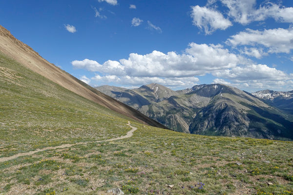
After peaceful forest hiking, you emerge into a vast, glorious high alpine meadow surrounded by craggy peaks.
Depending on the time of year, you may cross a snowfield or two on the way to your final approach to the pass.
After traversing the meadow, the trail again steepens, in switchbacks, up to Hope Pass. The trail continues down the other side, but our hike ends at the stunning, wind-swept pass.

Image credit: © Craig Brener
Recommended Guidebook
Online, you can review the hike on the Leadville 100 ultramarathon course map, the southern section of the course.
Additionally, the National Geographic: Trails Illustrated Topographic Map Guide series - #1203 Colorado Trail, Collegiate Loop is a good map to have with you.
Hope Pass Itinerary
From Leadville, travel south on Route 24 for 15 miles. Make a right onto Route 82, traveling west toward Independence Pass and Aspen. After 8 miles on Route 82 (2 miles past the village of Twin Lakes), look for the Willis Gulch Trailhead on your left (the south side of Route 82). The trail can also be accessed from the Parry Peak Campground 0.5 miles west of the Willis Gulch Trailhead. Additionally, some parking is available along Route 82 between the Willis Gulch and Parry Peak.
This hike starts gently, crossing Lake Creek via a bridge, then taking a connector trail east, paralleling the creek for a while until you encounter the first trail junction at 0.5 miles (0.8 km). Follow the sign directing you toward the Continental Divide trail and Hope Pass 5 miles ahead.
On our hike we came upon a beaver damming up a small stream beside the trail. We admired the creature, swimming back and forth, carrying one twig at a time, focused entirely on its task. We lingered at the spot, admiring and photographing; keeping our distance so as not to interrupt the beaver’s construction project. This chance encounter was magical, and a highlight of our hike.
The next trail junction arises after another 0.5 miles: Bear right to Hope Pass 4.5 miles ahead.
Soon breaks in the trees reveal appealing views of Twin Lakes to the northeast and mountains beyond.

Image credit: © Craig Brener
A mountain stream appears, and a wooden bridge. Just across the bridge is the junction with the Continental Divide Trail. From here, it is 3 miles (4.8 km) to the pass. Pay close attention to this junction for your return from Hope Pass.
Travel south on the Continental Divide Trail through gorgeous forest, which eventually opens into a vast meadow, with a narrow, dirt trail winding through.
Views of trees, small, scattered rocks, and mountains - some with spots of snow - greeted us at this point in our journey. Wood ruins, wildflowers, and a small lake added to the charm, as well as the babbling brook we hiked beside. The views behind us, where we came from, were even more impressive, and grew more so as we walked further toward the pass.
We crossed a small snowfield - it was mid-June when we hiked here - which was easily passable, as the trail went across, rather than up or down. Here I lost my trekking pole tip - and without wanting to dig around in my pack for my gloves, and my fingers growing icy, I waited for my husband to catch up and locate it for me. Happily, it was a quick retrieval.
Soon after, the trail began to head up again, gradually at first. Then a steeper series of switchbacks led to the pass! An American flag and Tibetan prayer flags marked this point.
It was quite windy, and a bit chilly once we stopped our upward exertion. Exhilarated by the grandeur, my daughter and I performed one of our karate forms. You may be inspired in other ways, but undoubtedly you will want to linger in this awesome location for some time (weather permitting).
Coming from the other direction, we met a lovely Norwegian solo traveler, through-hiking the Colorado Trail. She confirmed that this was one of the best spots she had encountered on her journey. After chatting and some photos we regretfully began our decent.
We had started later in the day than we had intended and needed to make a quick return. Fortunately, the quality of this trail enabled a fast descent, which we took advantage of, as we were running low on food, water, and sunlight.
The high altitude streams fed by the snow fields may be used to fill your water bottles near the top, but purifying your water is always recommended.
By the time we returned to our car and drove to the first restaurant we came upon in Twin Lakes, I could barely keep my head off the table and had to force myself to eat. (The vegetable soup restored me!)

Image credit: © Craig Brener
Hope Pass FAQ
When is the best time to hike the Hope Pass?
The best time to hike here is June through September, though in June you may find snow fields difficult to cross and September snow storms are not unheard of. Start your hike early in the day to reduce the chance of getting caught above tree-line in a mid-summer afternoon thunderstorm - so common in the Colorado Rockies.
Do I need a permit?
There are no permits or fees required to hike to Hope Pass.
How difficult is Hope Pass?
The hike to Hope Pass is more difficult because it's at higher elevation, topping out at 12,600 feet. If you're acclimated, it's not extremely strenuous, as the climb is not steep. If you're not acclimated, however, you'll likely feel the effects of low oxygen slowing you down. Be sure to drink plenty of water, and consume snacks, before you feel hungry or thirsty. Waiting for those cues is too late.
What Gear Will I Need?
Layers, a rain coat, proper hiking boots or sneakers (that you've worn before), sunscreen, water, lunch, and sunglasses are necessities. Gloves, hat, and even micro-spikes could be needed to complete the hike all the way to the pass. Trekking poles will help reduce the impact on your knees, give you stability crossing a snowfield, and provide more of a full-body workout.
Is the Trail Suitable for Families?
Yes! Parents know their own children best, but this trail is safe for families. If you're unsure how your children will do when the going gets more tough, perhaps wait another year. Or do what we did - start out and see what happens! Just be prepared to have to turn round, if necessary. Also, the elevation is a factor. If your children are under five, and don't live at high altitude, it's best to postpone this hike until they are older and more capable of dealing with the low supply of oxygen.
Are There Places to Refill Water Supply?
Yes! There are fresh mountain creeks that parallel this hike. Be sure to filter and treat your water prior to drinking.
What Wildlife Might I See?
It's possible you'll be fortunate enough to see a beaver. Marmots are common above tree-line scurrying among the rocks. Pika, mule deer, and black bear are all possibilities, as well.
Are Dogs Allowed on the Trail?
Yes.
Nearby Interests
The town of Leadville is charming and genuine. Browse the shops, restaurants, museums, and even an outdoor clothing factory right on the main street. If “upscale” is your preference, head west on Route 82 over Independence Pass and experience the excesses that Aspen has to offer.
For dinner in Twin Lakes, try the Twin Lakes Road House Lodge.

Nice description. It'e "cues' though – not "Queues". The latter is a line, not a cue that you need water, food, etc.