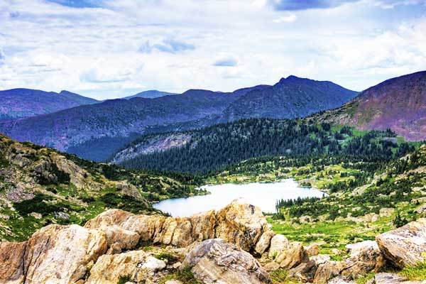
Her are our recommendations for the best hikes in Colorado. These hikes were chosen for a range of reasons; from the physical challenges they present to their scenic beauty.
There are options for people of varying degrees of fitness, from single-day to multi-day adventures.
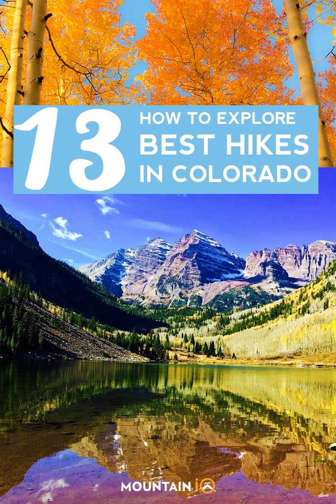
Best Hiking In Colorado
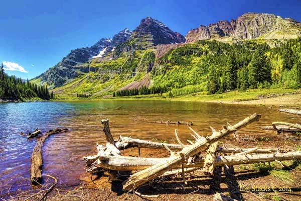
Maroon Bells Hikes
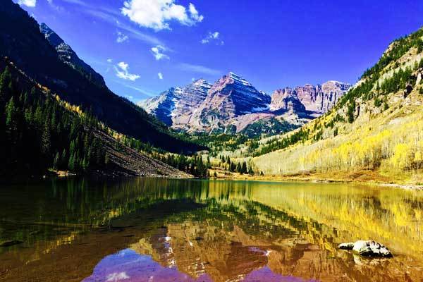
- Location: Near Aspen
- Distance: 1.6 km to 20.9 km (depending on route)
- Duration: Variable
- Difficulty: Variable
The Maroon Bells offer five different hiking route options for a range of abilities, from easy to moderately challenging. The national landmark presents some of the most iconic scenery in the country and is a very popular destination for tourists.
The Maroon Bells Lake is the most popular, followed by the Maroon Scenic Trail, where the crowds are less dense.
If you want to extend your trip by a couple of days, you can embark on the Four Passes Loop – it can take up to 5 days to circumnavigate the Maroon Bells-Snowmass Wilderness as well as the Elk Mountains via four passes.
You will gain access to tremendous views of the Rocky Mountains, several cascading waterfalls and fields teeming with wildflowers.
You may also like: Best Hikes in the Rocky Mountain National Park.
Fern Falls Hike
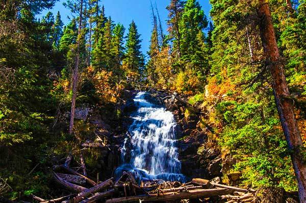
- Location: Rocky Mountain National Park
- Distance: 8.6 km
- Duration: ~3 hours
- Difficulty: Moderate
The Fern Falls Hike is scenically beautiful as it follows along the trickling Big Thompson river. First along the Windy Gulch Cascades, after which you will be led through boulders the size of houses, or Arch Rocks.
You will cross a bridge over the river at an area called The Pool and follow the pathway along with a number of switchbacks all the way to the Fern Falls.
If you enjoy fishing, bring along a rod and enjoy a couple of hours in the summer sun before you head back to civilization.
First and Second Flatirons Hike
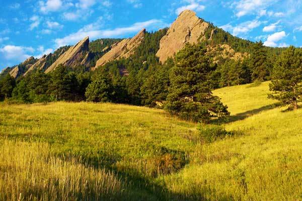
- Location: Near Boulder
- Distance: 4.2 km
- Duration: 2 hours
- Difficulty: Moderate
The Flatirons hike starts off in a sprawling, green meadow and through a notch between the First and Second Flatiron ridges.
The most common starting point is the Chautauqua Trailhead, from where you will weave through the Flatirons.
On the way back, you can take the Bluebird Mesa Trail which will take you through impressive pine dells before meeting back with the Chautauqua trail to deliver you back to the parking lot.
At various points along this hike, you will see views of the city of Boulder, the canyon between flatiron two and three, and distant vistas of the Rocky Mountains to the west.
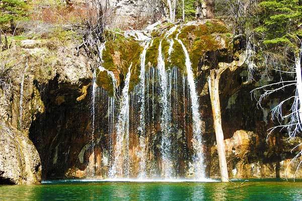
Hanging Lake Hike
- Location: Close to Glenwood Springs
- Distance: 4.3 km
- Duration: 2 – 4 hours
- Difficulty: Moderate
The Hanging Lake Hike is short in distance, but don’t underestimate the time you’ll spend on it.
The trail is steep and rocky, travelling through canyons and along a creek, and can be crowded with fellow tourists.
Once you reach the Hanging Lake itself you will be taken with its serene beauty – the lake appears as though it is suspended on the cliff edge by supernatural forces, with the striking blue water surrounded by lush, green plants.
The trail is open year-round, and the winter-time, frozen waterfalls are uniquely ethereal – but watch out for the tricky trail conditions. Continue along the trail until you reach Sprouting Rock, where you’ll be met with further vistas.
You may also like: Guide to the Manitou Incline in Colorado
Longs Peak Hike
- Location: Rocky Mountain National Park
- Distance: 21.8 km
- Duration: 14 hours
- Difficulty: Strenuous
Longs Peak Hike is one of the famous “fourteeners” – mountains which reach more than 14 000 ft. above sea level – and is not for inexperienced hikers. The mountain is the tallest of the Rocky Mountain National Park and receives a lot of intrepid visitors.
However, you should only attempt the climb if you are fit, healthy, acclimatized and a skilled mountaineer.
Although the hike takes about 14 hours to complete, it is advised that hikers are off the mountain by noon when afternoon storms are likely to interrupt your adventure.
This means that you have to start the climb at about 2 a.m. in the pitch dark, using only your head torch for a light which adds a whole new dimension to this experience.
You should reach the summit at around 10 a.m., from which you will see gorgeous views of Chasm Lake, Glacier Gorge and the surrounding Rocky Mountain National Park.
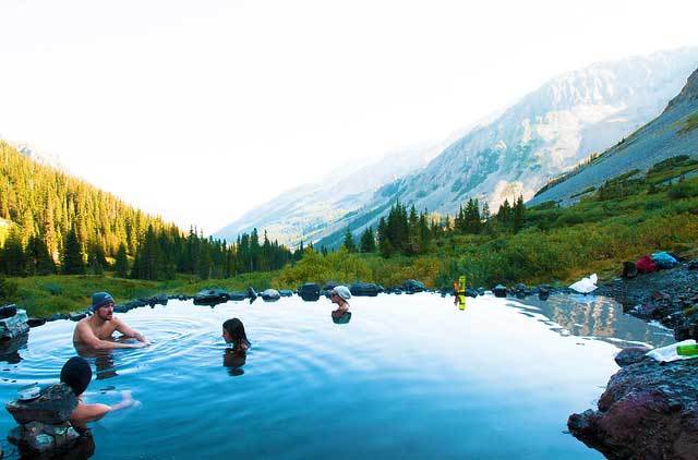
Conundrum Hot Springs Hike
- Location: Conundrum
- Distance: 26.8 km
- Duration: 1 – 2 days
- Difficulty: Moderate
Conundrum Hot Springs Hike can be completed in a single, long day with a bit of effort, or it can be stretched out into a mellow, two-day excursion.
From the trailhead at a parking lot, you will follow the well-defined path on a gentle incline through aspen groves, past fields of wildflowers and over charming bridges.
Eventually, you will end up at the bizarrely warm, seemingly unnatural springs, where you’ll be able to enjoy extensive views of the valley below. Start the return journey on the same path feeling rejuvenated.
Note that, as with most of the hikes to visit Colorado’s scenic specialities, this hike is highly populated. If you are trying to enjoy a more tranquil experience, avoid the weekends.
But if you are happy to participate in more of a “communal hike”, many people enjoy the hike at night-time, when the stars are glorious and the trail is bordering on rowdy.
Mount Elbert Hike
- Location: the Sawatch Range, southwest of Leadville
- Elevation: 4400m
- Duration: 1 day
- Difficulty: Strenuous
Mount Elbert is another of the “fourteeners” and its the highest peak in the entire Rocky Mountains and in Colorado. To attempt this trek, you should be fit, healthy, experienced and up for a challenge.
There are a number of routes to the top of ranging difficulty, the easiest of which are categorized as Class 1 or 2, or A + hikes, which don’t require any climbing experience.
The common routes to the top are well defined and easily accessible – the most significant obstacle to a successful ascent is, instead, the weather.
Heavy snow on the trail can make it tricky to traverse, and it can be very dangerous to be caught in one of the common summertime afternoon thunderstorms. Check the weather, and plan accordingly.
You may also like: Guide to hiking Hope Pass
Ice Lakes Basin
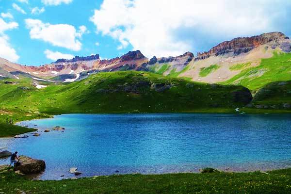
- Location: Silverton
- Distance: 12.9 km
- Duration: 1 day
- Difficulty: Moderate to strenuous
The steep hike to the Ice Lake would be worth it for the stunning view at the destination alone, but it is dotted with such awesome scenic treasures that the effort is a no-brainer.
The gradient is intense from the start, taking you through flowery meadows, and forests and past the breathtaking Lower Ice Lakes’ basin.
Here, the scenery opens up revealing Vermillion Peak, Golden Horn and Pilot Knob beyond the ridge at the basin’s edge. But this view is just a teaser – the final effort is intense but yields the view of the glorious, deep blue Upper Ice Lake surrounded by stark, dramatic peaks.
The lake is arguably the bluest in the Rocky Mountains and is met with awe by all its visitors.
Sky Pond Hike
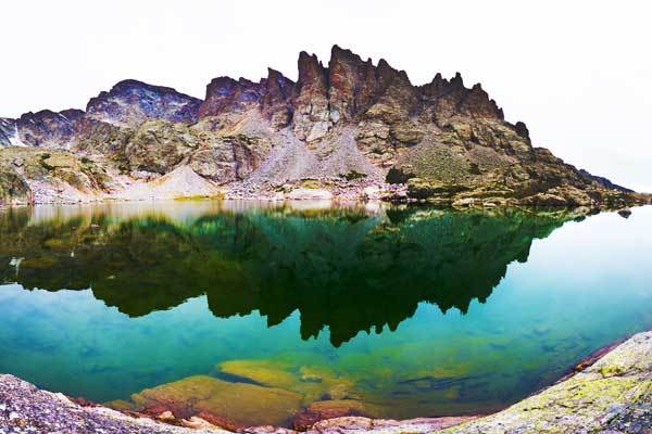
- Location: Rocky Mountain National Park
- Distance: 16 km
- Duration: 1 day
- Difficulty: Moderate
The hike to Sky Pond is a little less busy than its obvious alternatives, like Dream Lake and Emerald Lake, and passes several awesome landmarks along the way.
Starting off at the Glacier Gorge trailhead, you will first reach Albert Falls which is a very popular destination for the residents of the nearby Denver.
The crowds thin out as you head towards The Loch, an immense and idyllic lake. From here you will continue past the Lake of Glass and ends up at the eponymous Sky Pond.
Expect the path to become a little tricky as you approach your destination, but the end scene is more than worth the trek. Use the same route back to your car.
You may also like: best hikes around Denver
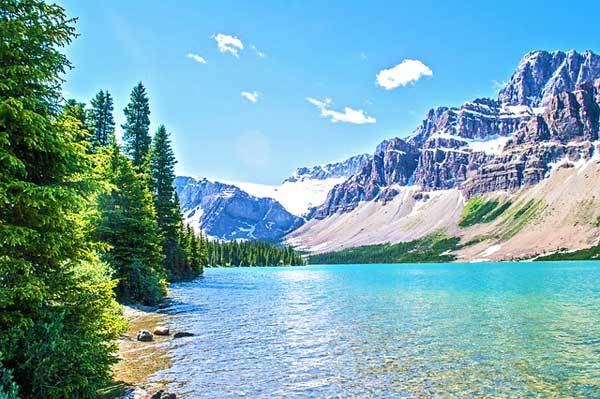
Crater Lake via Monarch Lake
- Location: Indian Peaks Wilderness
- Distance: 23.9 km
- Duration: 1 – 2 days
- Difficulty: Moderate to strenuous
The hike to Cater Lake starts from Monarch Lake, where you will check in at the Ranger Station. You will hop onto the Cascade Trail and begin the ascent of some manageable switchbacks which follow Buchanan Creek, winding through the iconic aspen woods and enjoying the gentle trickle of several waterfalls along the way.
You will pass springtime wildflowers, and possibly even moose if you keep your eyes peeled. Make sure you have an idea of the route you will be following because there are intersections that can get confusing.
The view at Crater Lake, shadowed by Lone Eagle Peak, is one you will want to spend time soaking up – so consider spending a night at the campsite before you head back via the same route.
Missouri Lakes Trail
- Location: Near Red Cliff
- Distance: 11.6 km
- Duration: 7 hours
- Difficulty: Moderate
The Missouri Lakes Trail starts by loosely following the winding path of Missouri Creek, crossing it at times, and passing tumbling waterfalls and sheer cliffs on the way.
For the first section, you will be surrounded by tree cover, which eventually opens up to serene alpine meadows.
After crossing the meadows, you will reach the Missouri Lakes basin, with its panoramic views of Savage Peak and other mountains.
The climb ends with a gentle incline, past minor lakes and intertwining smaller paths for the more adventurous explorer. Continue up the steep Missouri Pass, atop which you’ll gain access to expansive views of the surrounding lakes.
From here, you can either return via the same route or walk a little further to join the Fancy Pass trail to make the excursion a loop.
Elk Park or Needleton Loop
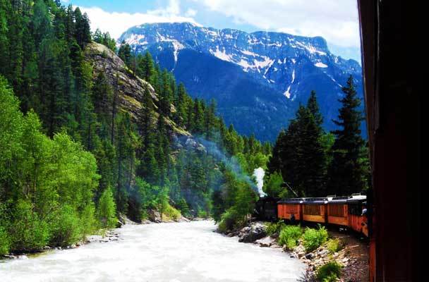
- Location: Weminuche Wilderness
- Distance: 77.2 km
- Duration: ~ 6 days
- Difficulty: Strenuous
The Needleton loop has everything you could want from a Colorado trek – alpine lakes, challenging climbs and plunging valleys.
The trail heads from Needleton, anticlockwise, up the Needle Creek Valley. From here you will traverse the approx. 3,840m Columbine Pass, follow the Vallecito Creek Trail, cross the Hunchback Pass and head on the Colorado Trail back to the railway.
Look forward to quiet walkways, emerald lakes, meadows of wildflowers, multiple waterfalls and a variety of wildlife.
Lost Creek Loop
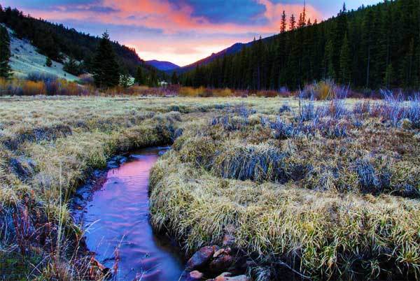
- Location: Lost Creek Wilderness
- Distance: 47 km
- Duration: 3 – 4 days
- Difficulty: Strenuous
The Lost Creek Loop is different from the other treks on this list – it doesn’t include expansive mountainous vistas and is instead an intimate experience.
You will be fumbling around to find your campsites and water sources, exploring intertwining pathways and at times being herded along by rangers who see you straying off track.
But the interaction with the natural world is what people love about the Lost Creek experience.
Along the way, you’ll encounter immense stone towers, the iconic meadows of wildflowers and a sporadically disappearing creak, which add to the hike’s intrigue while still maintaining the classic Colorado hike feel.
Hikes In Colorado FAQs
What part of Colorado has the best hiking?
An area of Colorado that is particularly renowned for its hiking is the Rocky Mountain National Park. The Rocky Mountain National Park is located in north-central Colorado and is home to over 350 miles of trails that range in difficulty from easy strolls to challenging multi-day backpacking trips. The park’s trails wind through stunning mountain landscapes, including high alpine tundra, pristine lakes, and dense forests. Popular hiking destinations in the Rocky Mountain National Park include the Bear Lake area, which offers easy access to several beautiful lakes and short hikes, as well as the Longs Peak area, which is known for its challenging summit hike. Other notable hiking areas in Colorado include the Maroon Bells-Snowmass Wilderness, the San Juan Mountains, and the Indian Peaks Wilderness.
What time of year is best to hike Colorado?
The hiking season in Colorado runs from late spring to early fall, with the peak season being from June to August. During this time, the weather is generally mild and the trails are generally free of snow.
Late spring (May and early June) can be a great time to hike in Colorado, especially in lower-elevation areas, as the wildflowers are in bloom and the weather is mild. However, higher-elevation areas may still have significant snow cover, which can make some trails impassable.
Summer (June to August) is the most popular time to hike in Colorado, as the weather is generally warm and dry, and the trails are generally snow-free. However, the summer months can also be crowded, particularly on popular trails.
Fall (September to early October) can also be a great time to hike in Colorado, as the weather is generally mild, the fall foliage is beautiful, and the crowds have thinned out. However, higher-elevation areas may start to see snowfall in the fall, so it’s important to check trail conditions before embarking on a hike.
Do I need a permit to hike in Colorado?
Many hiking trails in Colorado do not require permits or fees, but some do. It’s important to research the specific trails you plan to hike and check with the managing agency to see if any permits or fees are required.
For example, if you plan to hike in Rocky Mountain National Park, you will need to obtain a permit for backcountry camping and for climbing some of the higher peaks. Some other areas in Colorado may also require permits for backcountry camping, fishing, or other activities.
It’s also important to note that some popular hiking areas in Colorado may have limited access and require advanced reservations, especially during peak season. For example, access to the Maroon Bells-Snowmass Wilderness is limited during the peak season, and visitors are required to take a shuttle bus to the trailhead.
Other USA hikes by state:
- Best day hikes in Alaska
- Best day hikes in Georgia
- Best day hikes in Virginia
- Best day hikes in New Mexico
- Best day hikes in Southern California
- Best day hikes in Washington
- Best day hikes in Utah
- Best day hikes in Florida
- Best day hikes in America