Although not yet complete, the Great Himalaya Trail (GHT) is almost mythical among trekkers and it’s easy to see why.
The proposed trail stretches for 4,500 kilometres (2,800 miles) and passes through Kashmir, India, Nepal, Bhutan and Tibet. If finally completed, it would be the highest and longest alpine walking track on earth.
As of 2015, only the Nepal and Bhutan section of the trail have been completed.
The Great Himalaya Trail is made up of a huge network of pre-existing interlinking trails that wind through some of the tallest mountains in the world, including eight of the worlds fourteen 8,000 metre peaks.
The trail is broken up into sections that can be trekked individually or all as one, depending on your time frame. The landscape is incredibly varied and the trail passes through numerous climatic zones in some of the most remote places on earth.
The trail was only recently made feasible due to access restrictions placed upon many areas within Nepal, Bhutan and Tibet, particularly around the borders.
However, many restrictions were lifted in 2002 and the border areas were given the all clear which paved the way for the formation of the Great Himalaya Trail.
The trail was proposed in an effort to boost tourism in some of the lesser known areas of Nepal. Whilst Everest Base Camp trek and the Annapurna Circuit trek see thousands of tourists a year, there are literally hundreds of other trekking routes throughout Nepal that get little attention.
The Great Himalaya Trail was therefore conceived as a way of joining all the lesser-known routes together to increase awareness of these trails and bring tourism to the more remote parts of Nepal.
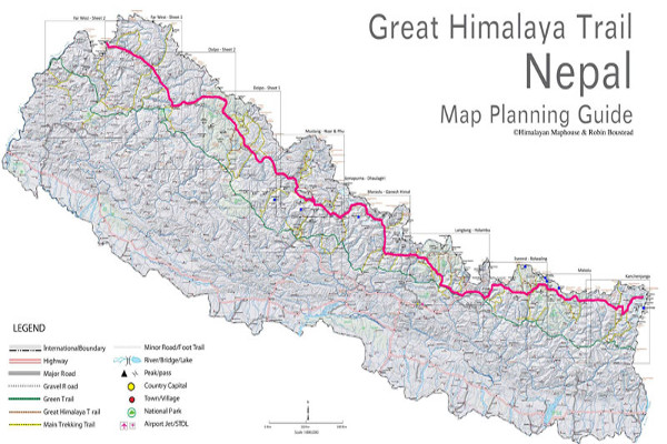
The Nepal section of the Great Himalaya Trail was officially opened in 2011 and covers a staggering 1,700 kilometers – separated into ten sections.
The trail takes 6 months and, if you were to use an operator, would cost in the region of US$30,000. Those few who have trekked the entire 1,700 km have described it as a spiritual journey.
The cultural experience is certainly mind-blowing and the remote wilderness has an alluring beauty that is hard to find in the populated world.
With such a wide range of interlinking trails, there are several options for trekkers – either the ‘High Route’ (also known as the Extreme Route) or the ‘Low Route’ (also know as the Cultural Route).
The High Route involves a considerable amount of high passes and you’ll often be trekking to altitudes of over 6,000 metres.
The trek usually takes about 150 days and requires mountaineering experience and equipment. The high route is not for the faint of heart and physical fitness is key as much of the trek is at high altitude and your camping and mountain equipment will need to be carried. Because of the remoteness of the trail, trekkers on the High Route have to camp most nights and will need the services of a guide.
The Low Route on the Great Himalaya Trail is far easier as the average altitude is 2,000 metres. This means temperatures are generally warmer and breathing is not made so difficult.
The trail winds through hills, pastures and lush forests, occasionally crossing a high pass. The highest altitude reached on the Low Route is 4,519 metres on the section between Dhorpatan and Dolpa in West-Nepal.
The trek is rich in culture and you pass through many authentic Nepalese villages and terraced rice fields. Unlike the High Route, you’ll be able to stay in tea houses and guest lodges for much of the trek and get hot meals almost daily.
The Low Route is also slightly shorter and stretches over 1,500 km instead of 1,700 like the High Route. Because of this, the trek takes roughly 100 days.
It is still unclear when the entire 4,500 km trail will be completed, however, for now the Nepal stretch is certainly long enough and provides an experience like no other! The trail is certainly a great opportunity for Nepalese tourism, especially for a country still recovering from a decade of civil war.
The trail is already building tourism in remote areas and the future hope is to draw tourists into regions without the big name mountains that attract so many tourists to other parts of Nepal every year.

Hey, we plan to attempt the GHT and we struggle to find some maps with the low route. I wonder where you taken the map in this article ( Great Himalayan trail – Nepal -Map planning guide). If you give me the link that could be awesome!
Hi Vincent, not sure where we sourced that map but your best net for a good map is this planning guide: https://amzn.to/2O6WlxX.
i need full map in one page where buy? how to charge camera on trail
Hi Rana, here is a good route and planning guide: https://amzn.to/2O6WlxX. Many teahouses will have electricity and charging points, but the remote parts of the trail will be black spots for teahouses and electricity.