The Annapurna Circuit is one of the most popular and most epic treks in Nepal. This classic trek meanders through Himalayan foothills and over high passes, offering picturesque mountain views along the way.
Annapurna Circuit Trek
Route Overview
The Annapurna Circuit is one of the greatest treks in Nepal, if not the world.
Although road construction over the past two decades has severely impacted the trekking experience (more on this later).
Note: if you are a mountain biker, the road on the western side makes for one of the most exhilarating and scenic mountain biking experiences!
Where Does The Annapurna Circuit Start and End?
The trek begins at Besisahar (which is a 7-8 hour drive from Kathmandu) and concludes in the Kali Gandaki Gorge – the disputed highest gorge in the world that separates Dhaulagiri (8,176 meters) in the West and Annapurna (8,091 meters) in the East.
The circuit is traditionally followed on an anti-clockwise trail – for acclimatization reasons – that circumvents the Annapurna Massif. It takes trekkers through the Annapurna, Manang and Mustang region of central Nepal.
Route Details
At its pinnacle, the trek crosses the Thorung La Pass (5,416 meters) before descending down to the town of Muktinath. From here the road construction activities (2004 -2008/09) have had a measurable impact on the Annapurna Circuit trekking experience.
The Nepalese government have realized that the road on both the Western (Pokhara-Muktinath) and Eastern (Chame-Manang) side of the circuit has had a negative impact on trekking tourism. Thus, they have created a number of New Annapurna Trekking Trails (called NATT-trails).
These NATT-trails, marked blue and white or red and white, take trekkers away from the dusty and unpleasant roads. The alternative routes provide a much more pleasant trekking experience.
How Long Is The Annapurna Circuit?
The Annapurna circuit typically takes between 16-20 days to complete. This is depending if you decide to tack on a diversion to Annapurna Base Camp and the Annapurna Sanctuary). It covers between 150-240 km depending on when you decide to end the tour or use transportation vehicles.
Scenery and Landscape
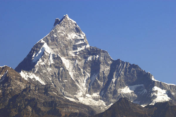
The scenery on the Annapurna Circuit is extraordinarily beautiful. Trekkers pass through rice terraced paddy fields, subtropical forests, and glacial environments.
You will see a number of major mountains including the Annapurna Massif (I-IV), three 8,000 metre peaks – Dhaulagiri (8,176 meters), Manaslu (8,156 meters) and Annapurna I (8,091 meters). There are numerous other peaks of 6,000 to 7,000 meters.
Please Note: The Annapurna Circuit is situated in the Annapurna and Mustang regions of central Nepal. It is home to the Annapurna Massif. The schematic below illustrates Nepal’s trekking regions (not to scale).
Annapurna Regional Map
The Annapurna Circuit is situated in the Annapurna and Mustang regions of central Nepal. It is home to the Annapurna Massif. The schematic illustrates Nepal’s trekking regions (not to scale)

Annapurna Trek Altitude Profile
The schematic diagram below shows the route altitude profile for the Annapurna Circuit.

Annapurna Circuit Itinerary
Below is a detailed Annapurna Circuit itinerary. Where possible we have highlighted the NATT-Trails that can be used to avoid the road. Please note that this is a typical Annapurna Circuit itinerary. Some tour operators offer variations on this route.

Day 1-2: Arrive Kathmandu (Drive to Besisahar / Fly to Pokhara)
Day 3: Trek from Besisahar (820 meters) to Khudi and onto Bahundanda (1,310 meters)
Day 4: Trek from Bahundanda (1,310 meters) / or Sirung (2,200 meters) to Jagat (1,300 meters) or potentially Chamje (1,410 meters)
Day 5: Trek from Jagat / Chamje (1,300 / 1,410 meters) to Dharapani (1,960 meters)
Day 6: Trek from Dharapani (1,960 meters) to Chame (2,710 meters) via Bagarchap and Danakyu, and then either along the lower trail or upper trail to Koto (2,640 meters)
Day 7: Trek from Chame (2,710 meters) to Pisang via Bhratang (2,850 meters) and Dhukur Pokhari (3,240 meters)
Day 8: Trek using the upper trail from Pisang (3,310 meters) to Manang (3,450 meters) via Ghyaru (3,730 meters), Ngawal (3,680 meters), Humde (3,330 meters and Bhraga (3,450 meters)
Day 9: Acclimatization day in Manang
Day 10: Trek from Manang northwest out of the Marshyangdi Valley and up to the small village of Yak Kharka (4,110 meters)
Day 11: Trek from Yak Kharka (4,110 meters) to High Camp (4,850 meters)
Day 12: Trek from High Camp (4,850 meters) across the Thorung Pass (the highest point on the trek at 5,416 meters) and then back down to Muktinath (3,800 meters) via Charabu (4,230 meters)
Day 13: Trek from Muktinath (3,800 meters) to Marpha (2,665 meters) via the awesome village of Kagbeni (2,800 meters)
Day 14: Trek from Marpha (2,665 meters) to Kalopani (2,530 meters), via Chokhopani, and continue to Kokhethanti to avoid the road
Day 15: Trek from Kolapani (2,530 meters) to Tatapani (1,200 meters)
Day 16: Trek up from Tatapani (1,200 meters) to Ghorepani (2,870 meters)
Day 17: Trek from Ghorepani (2,870 meters) up Poon Hill (3,870 meters) and back down to Tadapani (2,710 meters)
Day 18: Trek from Tadapani (2,710 meters) to Naya Pul (1,070 meters) via Gandruk and then catch a short bus ride back to Pokhara
Please Note: From Muktinath onwards the classic Annapurna Circuit has been severely impacted by the road that joins Jomsom to Muktinath. If you choose to trek this route be prepared for an unpleasant and dusty experience, as jeeps wiz by you. Thankfully there are alternative options via the New Annapurna Trekking Trails (NATT-trails).
Suggested route options from Muktinath
If you are not on a set tour we suggest the following route:
- Trek to the charmingly wonderful town of Kagbeni (2,800 meters) for an overnight stay. We recommend taking the high trail out of Muktinath via Jhong, as this offers better mountain views
- From Kagbeni to Jomsom take a jeep as dust driven from the common winds in this region and the constant flow of vehicles on the road make for unpleasant trekking
- From Jomsom take the new NATT-trail (marked in red and white) to Marpha (2,665 meters) where you can stay overnight and then continue following the route set out from Day 13 below
Also Note: As the road starts in Muktinath, you can cheat and catch a truck all the way to Jomsom. Continue your trek or catch a flight to Kathmandu if you need to shorten your trek (we highly recommend not skipping Kagbeni though).
You can also get a bus from Muktinath all the way back to Pokhara if you have run out of time. If you are a mountain biking fanatic you can rent a mountain bike to take one of the most amazing rides down and out of Muktinath – this area of Nepal is fast becoming mountain biking Mecca
Annapurna Route Variations
There are a number of route variations on the Annapurna Circuit. Here are three worth mentioning.
If you don’t have much time in the Annapurna Circuit you may want to consider the Poon Hill Trek, The Royal Trek or the Ghorepani Poon Hill Trek (also called the small Annapurna Circuit). Nepal is heaven for trekkers and has some of the best thru-hikes in the world.
- Naar-Pho Valley
- Tilicho Lake
It is possible to include a five day diversion to Annapurna Base Camp onto the Annapurna Circuit trek. This involves continuing north from Tadapani so as to join the old Annapurna Circuit at Landruk.
Read more about the Annapurna Base Camp Trek
Recommended Guidebook

Need an up-to-date guide book with maps that include the NATT-Trails? We recommend either Andrées de Ruiter and Prem Rai’s guide, Trekking the Annapurna Circuit, or Sian Pritchard-Jones and Bob Gibbons guide, Annapurna: A Trekker’s Guide.
Annapurna Circuit FAQ
How much does it cost to hike the Annapurna Circuit?
The cost of an Annapurna Circuit varies depending on which route variation you take. It also depends when you trek (out of season tends to be a little cheaper) and whether to trek with a local or western trekking agency, or indeed independently.
We have provided a detailed Annapurna Circuit Cost article here but in summary you should budget for the following key expenses:
Visa, Vaccinations, Insurance etc:~$300-$500
Equipment (buying and hiring):~$500-$800
Flights to Kathmandu: ~$1,000
Tour Agency: ~$1000 for a cheap local agency to ~$3,000 for a pricey Western trekking agency. You could do an independent trek for ~$700 employing a local guide
check out our list of Nepal trekking companies recommendations.
Tips: ~$200-$300
Misc (additional food, unplanned travel / hotels ect): $200
Total Costs: $2,500 – $5,000
Do I need a permit for the Annapurna Circuit?
Yes. An Annapurna Conservation Area Project permit and Trekker Information Management System registration are required for the Annapurna Circuit trek.
If you are joining an organised tour, these will be arranged for you. If you are looking to go it alone you will have to bring four passport-sized photographs and go to the offices of the Nepal Tourism Board in Kathmandu to apply. We recommend bringing copies of your passport and insurance policy. The offices follow government working hours and days, and are not open on Sunday.
When is the best time to hike the Annapurna Circuit?
The best time to trek the Annapurna Circuit is either in the Spring (March to Mid May) or in the Autumn (mid / late September to December). Unfortunately these also happen to be the busiest times of the year as they are the best time for Nepal trekking..
Towards December the weather starts getting particularly cold and the routes get distinctly quieter. If you are a hardened trekker a winter Annapurna Circuit (late December through February) can provide a very authentic Nepal trekking experience.
The main challenge of a winter trek, apart from the cold, is the snow and ice that often obstructs the higher trails and the Thorung Pass. During bad winter seasons these trails may be closed.
Unlike the Everest region that gets very wet during the rainy monsoon season, the Annapurna and Mustang regions stay relatively dry, making June through September, a relatively good time to trek as well.
Here’s a detailed article on weather on the Annapurna Circuit.
Is altitude sickness a risk on the Annapurna Circuit?
Yes, some trekkers do suffer from altitude sickness on the Annapurna Circuit as it is a high altitude trek. At its highest point, Thorung Pass, you will reach an altitude of 5,416 meters (17,769 feet).
Fortunately because of the circuits length the opportunities for appropriate acclimatisation are good. Hence, the prevalence of moderate or sever altitude sickness is low.
Nonetheless, it is important to have a detailed understanding of the risks associated with high altitude trekking and how the body acclimatises.
We recommend you read our detailed article on Altitude Sickness and Acclimatisation.
How difficult is the Annapurna Circuit hike?
The Annapurna Circuit trek is challenging. You will be trekking for 4-7 hours a day for over two weeks, so you will need to be peak physical condition. The best way to prepare is to get as many kilometres under foot on hikes in your home country.
What do I need to pack for the Annapurna Circuit trek?
Trekking in the Annapurna region requires a number of essential pieces of trekking clothing and equipment. AC is a long and tough trek. You will be exposed you to a range of altitudes where temperatures fluctuate dramatically between night and day.
Many pieces of equipment can be rented or bought in Kathmandu or Pokhara. Even so, we recommend bringing the most important pieces of gear with you.
We've written a detailed Annapurna hiking packing list.
Insurance Information
Trekking insurance is a must in Nepal. This is particularly the case in the Annapurna Region, which at stages is very remote. If an accident should occur that requires medical assistance and evacuation you will definitely want trekking insurance that can cover the costs of air ambulance and treatment.
Moreover, it is prudent to have insurance that covers you for any travel related risks. insurance should cover stolen, damaged or delayed baggage; flight delays and interruptions; and tour operators default.
This article on travel and trekking insurance in Nepal provides detailed information on what type of insurance you need.

Hi Mark,
Great information thanks. I am trekking the APC in October with a local company. I think I have all the bases covered but would you recommend anything of that is more important than anything.
Hi Tony, make sure you have some warm layers, gloves and beanie for the pass, and that you’re guide is clued up on the weather forecast for the days leading up and over the pass. Otherwise, enjoy, you’re in for a treat!
Hi Mark,
I'm looking to do a trek around the 2 week period in january.
What would be your recommendation, preferebly in asia.
Thanks
Hi Hugh, this is winter time in Asia so I would stick with a well trodden path like EBC: https://www.mountainiq.com/guides/trekking-in-nepal/routes/everest-base-camp-trek/
Hi Mark, this is a really nice blog with very comprehensive information!!
I'd like to do the trekking on my own, as an independent trekker, but I've heard that there are some new regulations comming for this year (2023) and that a local guide or agency is mandatory to do the central part of the annapurna circuit. Also, that the TIMS can not be got by independent trekkers but only if you hire an agency.
Would you have any up to day news about it?
Thanks
Hi Daniel, thanks for checking in. I’m not aware of the new regulations, but it is definitely possible. Nepal authorities have been talking about this for years. Here’s the latest from the Guardian: https://www.theguardian.com/travel/2023/mar/30/nepal-imposes-ban-on-mountain-trekking-without-a-guide
Thanks for the useful information. Really helpful!