The Cordillera Huayhuash Circuit is known to be one of the most challenging and most beautiful treks in South America.
This guide will help you plan your Huayhuash trek, whether you’re going independently or with an experienced guide or trek operator.
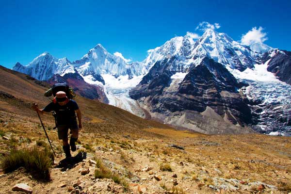
Cordillera Huayhuash Circuit Overview
The Cordillera Huayhuash Circuit is a 68 mile / 110km trek through a remote region of the Peruvian Andes. Elevations on this trail reach upwards of 16,600 feet/ 5,060m.
The region was made famous by the tragic mountaineering book (and film) Touching the Void. It is a survival story of a climber who falls into a crevasse after his partner is forced to cut the rope, then has to save himself. Don’t worry though. There is no mountaineering involved on the trail.
The appeal of the Cordillera Huayhuash Circuit is in the scenery. This region is brimming with turquoise alpine lakes, craggy snow-covered peaks, open green fields, misshapen multi-colored mountainsides, and fire-hued sunsets.
It takes anywhere from 7-14 days to complete the Huayhuash circuit, with 10 days being the average pace. There is only one village where you can resupply along the way. Otherwise, it’s entirely a wilderness experience. Be fully equipped with all the gear you need to sleep, cook, and stay warm and dry in the mountains.
The Cordillera Huayhuash region is not nearly as popular of a destination as it’s Cordillera Blanca counterpart. While you will likely see a few other groups every day, it is certainly not a busy destination.
If doing this trek independently, you will arrive via public transportation to Pocpa. From there it takes a few hours to walk to the start of the trail. Alternatively, you could arrange transport with a trekking agency.
It is better to bring backpacking snacks from home for the trek, as the options at the grocery store are limited. If you’re on an extended trip and not beginning from home, perhaps you could do your food shopping in Lima.
There are no permits required for the Cordillera Huayhuash Circuit. However, there are nine different communities charging fees for land use. The total price for all the fees adds up to about 205 soles ($62).
Cordillera Huayhuash Trek Facts
- The distance of this trek is 68 miles / 110km and takes 7-14 days to complete. Most people hike in a clockwise route.
- The maximum altitude on the circuit is 16,600 feet/ 5,060m. There is a total of 18,700 feet/ 5,700m of vertical uphill walking.
- Difficulty is strenuous. It’s a high-altitude, wilderness hike with drastic elevation changes.
- Best months to hike the Huayhuash circuit are May- September.
- Guides are not mandatory, but are recommended for inexperienced trekkers.
- No permits required. There are campsite and land use fees that amount to a total of 205 soles/ $62.
What to expect while trekking the Cordillera Huayhuash circuit
Typical Itinerary
Huaraz: 2-3 Nights
The city of Huaraz sits at 10,000 feet/ 3,050m. I recommend spending several nights here in order to start acclimatizing. Take a bus out of town and do a day hike to further help with acclimatization.
Additionally, if you have any extra belongings you don’t want to take on the trek, you can store them at your hotel or hostel.
Day 1: Quartelhuain
Catch the 5 am bus from Huaraz to Chiquian. The bus company is called El Rapido. From Chiquian, take the 8 am bus to Pocpa. Once you’ve arrived in Pocpa, it takes several hours of walking along the road to reach Quartelhuian. Spend the night there.
Day 2: Mitucocha Camp
Elevation gain: 1,706 feet/ 520m
It’s a relentless climb up to Cacananpunta first thing in the morning. Then a mellow hike down to the campsite. While this is a short day, I recommend staying at Mitucocha Camp. It’s better to ease into the trek than do two big climbs on the first day in the backcountry.
Day 3: Carhuacocha
Elevation gain: 1,400 feet/ 430m
The climb up Carhuac is rewarded by views of snow-capped peaks on the descent. The campsite is beside an alpine lake and is an excellent spot to catch some sunset photos of the lake and mountains. This campsite is not very large, so expect to be in close proximity to any other trekkers.
Day 4: Huayhuash
Elevation gain: 1,300 feet/ 400m
Today is one of the most spectacular days as far as scenery goes. There are several alpine lakes that act as mirrors to the surrounding peaks.
You can even jump in one if you’re feeling bold and not afraid of the cold. Expect to hear and see giant chunks of ice breaking from the surrounding cliffs and crashing to the ground.
Day 5: Viconga
Elevation gain: 1,380 feet/ 420m
Today is just as scenic as all the rest, but perhaps the highlight of this day is the Viconga campsite. There is a hot spring for weary trekkers to soak in while enjoying the surrounding mountains. The man-made concrete tubs are filled with natural hot spring water, and it’s the perfect way to end a long day.
Day 6: Cuyoc Camp
Elevation gain: 2,330 feet/ 710m
This is the biggest elevation gain of the hike so far. However, it’s not as steep as previous climbs and you should be well acclimatized by now. Take it slow. You’ll be rewarded at the top with views of peaks and colorful mountains.
Day 7: Huatiaq
Elevation gain: 2,525 feet/ 770m; however, there will be additional elevation gain if you choose to take the scenic route in the morning
The guidebook suggests two days to reach Huatiaq from Cuyco Camp, but it is possible to do in one. This is also the day you can go to Huayllapa to resupply. You can start your morning by choosing your route: a more scenic, uphill climb. Or an easier walk down the valley if you’ve had enough of stunning mountain scenery.
There’s a small shop in Huayllapa where you can buy basic supplies. They don’t have anything too extravagant; just Ramen noodles, oatmeal packets, and packages of cookies.
After visiting the village, start the steep climb up to the campsite.
Day 8: Incahuain
Elevation gain: 2,750 feet/ 840m
This is the last full day of trekking the circuit. There are two passes today, and after you can choose to do a ridgeline walk if you want to get some bonus views. The ridgeline is not too difficult, so you might want to give it a go. Finally, after more alpine lake views, you descend down to your final campsite of the trek.
Day 9: Llamac
Elevation gain: 1,100 feet/ 340m
Set off early if you’re planning on taking public transportation back to Huaraz. The bus leaves around 11:30am. There is one final low pass to get over, then you hike down into the village of Llamac.
Things You'll Need for Your Cordillera Huayhuash Trek
Gear Checklist
- Backpack (about 50L)
- Trekking poles
- Tent (there are no trees for tying tarps or hammocks)
- Sleeping bag, around 20 F (-7C) and a sleeping pad (in case you aren't hiking with a tour operator)
- Camp stove and fuel canister, can be purchased in Huaraz
- Water bottles, capacity for 2-3L
- Water treatment method
- Navigational equipment: map, compass, guidebook, GPS or SmartPhone
- Hiking clothes
- Trail runners / hiking boots
- Rain jacket
- Down jacket / warm synthetic layer
- Long-sleeve base layer shirt
- Base layer bottoms
- Warm hat and gloves
- Sunscreen and trekking sunglasses
- Toiletries
You're welcome to check out our multi-day hiking list for more helpful ideas on what to pack for Cordillera Huayhuash.
Recommended Guidebooks and Maps
Peru’s Cordilleras Blanca & Huayhuash: The Hiking & Biking Guide is the most comprehensive resource on the circuit.
Please Note: The latest version of this guidebook will go on sale on Amazon on 1 September 2023. So, make sure you're first in line to buy it!
You can also download the maps.me maps of the region, since a lot of the trail is marked on the app.
If you’re trekking without a guide, we recommend buying a map at one of the trekking shops in Huaraz.
Please Note: It’s important that hikers who go without the assistance of a guide and mules are aware of what they’re getting into. This is a high-altitude trek through a remote region of the Andes with no road access. Should something go wrong, it would not be easy for help to arrive.
Hikers must be fully equipped with enough food to last until the village of Huayllapa. The threat of acute mountain sickness is real, and hikers should have an understanding of symptoms and treatment.
Furthermore, there are no trail signs and sometimes the path is not obvious. Trekkers should have a basic understanding of navigation and carry a map, compass, and GPS or SmartPhone with the regional maps downloaded for offline use.
Cordillera Huayhuash FAQs
When is the best time to hike Cordillera Huayhuash?
May to September are the best times to hike the Cordillera Huayhuash Circuit.
The weather is cold, but dry. Expect frost on your tent every morning and have layers accessible during the day.
The other months of the year are the wet season, and the passes will likely be difficult to cross because of snow.
What can I expect on a typical Cordillera Huayhuash trek?
There are no permits for this trek but bring enough money for the land use fees. They amount to 205 soles ($62).
Take the local buses to get to the trailhead. Arrange your ticket the day before at the El Rapido bus station in Huaraz.
The bus to Chiquian leaves at 5am, and from there you will catch a different bus to Pocpa. On the last day of your hike, catch the 11:30am bus out of Llamac.
Either bring food for the trek from home or buy it in Lima, as Huaraz does not have many good options for backpacking food.
How difficult is the Cordillera Huayhuash Circuit Trek?
The Cordillera Huayhuash Circuit is an extremely difficult trek, especially if you are planning to self-navigate and carry your own gear.
While the distances may seem small, keep in mind that it is at a high altitude with drastic elevation changes.
Furthermore, there is no easy way to get out should you experience symptoms of acute mountain sickness.
Therefore, it is crucial that you take several days to acclimatize in Huaraz and do a day hike before beginning the circuit.
Is it safe to hike the Cordillera Huayhuash Circuit alone?
In terms of is the region safe for tourists, yes, very much so. In terms of if the mountains are safe for you personally, this really depends on your experience.
Ask yourself these questions:
- Do you feel comfortable navigating your own way in the mountains?
- Have you gone on a backcountry trip of similar length before?
- Do you have experience hiking at high elevations?
If the answers are yes, then you are probably ready.
Where do I find water along the Cordillera Huayhuash Circuit?
All of the Cordillera Huayhuash campsites have water sources, and there are streams throughout the day as well. Just be sure to fill up before you start up the passes, as you might hike several hours between water sources during the day.
Is acute mountain sickness a risk with Cordillera Huayhuash?
Yes. Do proper research ahead of time on what the symptoms of mountain sickness are and be aware of how to treat it. You can read about acute mountain sickness.
Do I need travel insurance for Cordillera Huayhuash?
If you plan to hike Cordillera Huayhuash Circuit, make sure that you are adequately insured for up to 4,000m. Get a quote from Rise & Shield.
Do I need to know Spanish for Cordillera Huayhuash?
Not necessarily, but it is helpful if you learn a few Spanish phrases. While traveling around Peru, it will be a challenge to get around if you are only trying to speak English.
Once on the trail, you really don’t need to speak to that many people other than the locals who collect land use fees. If you don’t know Spanish, don’t let it be a deterrent to coming to Peru. Just be ready to have a tough time.
You may also like...
See our detailed guide to South American mountain ranges. Or check out our country hiking guides below.
Also see our detailed Mountain Guides or explore our Hiking Tours available exclusively on Mountain IQ.
References: BBC Travel, Lonely Planet, Wikipedia

