This page provides a comprehensive and impartial guide to climbing Kilimanjaro via the Rongai Route.
Rongai Route Overview
The Rongai Route is the only trail which starts on the Northern, or Kenyan side of Mount Kilimanjaro, and it receives the least traffic of all the guided trails up the mountain (except for the Northern Circuit).
As the Northern side of the mountain is less inhabited and touristy, trekkers will experience unspoilt wilderness and possibly see large wildlife such as antelope, elephant and buffalo.
The Rongai Route, while flatter than other Kilimanjaro routes, does not offer hikers the opportunity to climb high and sleep low, and therefore it can be difficult for trekkers to acclimatize properly.
While the Rongai route can be climbed in six days, it is highly recommended that trekkers take seven or eight days to experience this beautiful trail, allowing their bodies extra time to acclimatize.
As the Northern side of Mount Kilimanjaro receives less rain, trekkers are more likely to have clear, unclouded views of Uhuru Peak.

Rongai Itinerary
While a trekker's best chance of success lies with the seven route, the Rongai Route is also operated as a six-day trek. Below is a detailed itinerary for the six-day route. For details on the longer variations, see the Route Variations section below.
Day 1
- Distance: About 6.5km, or 3.5 miles
- Trekking time: 3 to 4 hours
- Change in elevation: 670 meters
- Landscape: Rainforest
On the first day, trekkers are driven from either Moshi or Arusha to Marangu Gate for registration. After signing into Kilimanjaro National Park, trekkers are driven a further 70 kilometers over rough roads to the Rongai Start Point (1,950 meters) at Nale Moru village. An easy hike through cornfields and rainforest follows, with trekkers arriving at their camp of Rongai First Cave (2,620 meters) in the afternoon.
Day 2
- Distance: About 12km, or 6.5 miles
- Trekking time: 6 to 8 hours
- Change in elevation: 980 meters
- Landscape: Rainforest; Low Alpine
Day two takes hikers from Rongai First Cave (2,620 meters) further into the rainforest, which eventually gives way to low alpine moorlands as the trail approaches Rongai Second Cave (3,450 meters), where six- and seven-day trekkers will stop for lunch. (Eight-day trekkers will typically spend the night here.)
After lunch, six- and seven-day trekkers will continue on towards the east for about another 6 kilometers before arriving at Kikelewa Camp (3,600 meters), where they will spend the night.
Day 3
- Distance: About 4km, or 2.5 miles
- Trekking time: 3 to 4 hours
- Change in elevation: 700 meters ascent
- Landscape: Low Alpine; High Alpine
The third day of hiking on the Rongai Route is short, but steep. The trail leads from Kikelewa Camp (3,600 meters) to Mawenzi Tarn (4,300 meters). After arrival at Mawenzi Tarn, hikers have the afternoon off to explore the area and acclimatize in the rarefied air.
Day 4
- Distance: About 9km, or 5.5 miles
- Trekking time: 8 to 10 hours
- Change in elevation: 400 meters
- Landscape: High Alpine
On day four, trekkers follow a long, gradually-ascending route from Mawenzi Tarn (4,300 meters) up to Kibo Hut (4,700 meters), passing between the peaks of Kibo and Mawenzi. The high alpine landscape is dry and rocky, but trekkers should expect good views of Kibo.
An early bedtime awaits at Kibo Hut, as the summit attempt begins late in the evening (11:30pm). Trekkers should prepare their gear for the summit bid (headlamp, cammera, insulated water bottle) before falling asleep.
Day 5
- Distance: About 5.5km (3.5 miles) ascent and 15km (9 miles) descent
- Trekking time: 6 to 8 hours to the summit, followed by 5-8 hours of hiking to Horombo Hut
- Change in elevation: 1,195 meters ascent, 2,175 meters descent
- Landscape: Glacial at the summit; high alpine and low alpine on the descent
Today is the day! However, it begins at midnight. After a snack of tea and biscuits, trekkers make their way through the darkness along a rocky path towards Hans Meyer Cave (5,150 meters). Beyond this cave, the trail becomes steeper and there are many switchbacks as you climb higher into the frigid air.
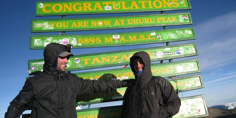
Two to three hours later, trekkers arrive at Gilman's Point (5,681 meters) on the edge of Kibo's crater rim! This is not the summit however, and to reach the summit requires an additional 200 meter ascent. Uhuru Peak is worth the effort!
After reaching the summit of Kilimanjaro at Uhuru Peak, trekkers will have a long hike back to Kibo Hut and on to Horombo Hut before a well-deserved rest. The day typically lasts 12 to 16 hours, but the memories will last a lifetime!
Day 6
- Distance: About 20km, or 13 miles
- Trekking time: 6 to 8 hours
- Change in elevation: 1,850 meters
- Landscape: Low alpine; Rainforest
The last day on the Rongai Route is another long one, stretching an additional 20 kilometers from Horombo Hut to Marangu Gate. Trekking poles are highly recommended for this portion of the hike, as hikers will be losing almost 2,000 meters of elevation in one day. Upon arrival to Marangu Gate, trekkers sign out.
Those trekkers who reached Gilman's Point but did not reach Uhuru Peak will receive a green certificate to commemorate their accomplishment, and those who made it to Uhuru Peak receive a gold certificate. It is customary to tip the trekking team at this point before being driven back to your hotel in either Moshi or Arusha for a hot shower and some good sleep!
Rongai Route Pros and Cons
Pros
- Only Northern approach to Kilimanjaro
- Relatively quiet trail with amazing panoramic views of Kilimanjaro
- Good summit success rates on the 7-day variation
Cons
- Long drive to the start point
Rongai Route Map
The summit approach is via Gilman's Point on the eastern side of Uhuru Peak.
Descent is via the Marangu route.

Rongai Altitude Profile
On the 7-day trek, climbers spend an additional acclimatization day at Mwenzi Tarn before continuing on.
Rongai Route Variations
The Rongai route can be climbed as a six, seven or eight-day trek. For the seven-day trek, climbers spend an additional acclimatization day at Mwenzi Tarn before continuing on. Eight-day trekkers will also spend a night at Rongai Second Cave on day two before continuing on to Kikelewa Camp.
")
Rongai Route FAQ
How much does the Rongai Route cost?
The cost to hike Rongai Route is on average $2500. This cost will vary based on a few factors, such as what season you choose to hike, whether you choose the six, seven or eight-day option, or whether you choose to use a Western guiding company or work directly with a local guiding company.
Here are the major costs to consider when planning to undertake the Rongai Route:
- Visa, Vaccinations, Insurance etc: ~$300-$500
- Equipment (buying and hiring): ~$200-$300
- Flights to Kilimanjaro International Airport: ~$800
- Tour Agency: About $1,800 for a cheap local agency to ~$3,500 for an expensive.
- Tips: ~$200-$300
- Misc (additional food, unplanned travel / hotels etc): $200
- Total Costs: $3,200 – $5,500
Are permits required for the Rongai Route?
A permit is required to climb Kilimanjaro, regardless of route. Furthermore, all trekkers must be accompanied by a guide and porters. If you are joining an organised tour, these will be arranged for you.
When is the best time to trek the Rongai Route?
June-September is the best time to climb Kilimanjaro, as the weather is best. That said, since it is close to the equator it is possible to climb the mountain at any time of the year. April and May are the rainy season so most hikers avoid these months. November is a short rainy month, however the northern side of Kilimanjaro is in a rain shadow so if you are confined to this month then the Rongai is a good option.
How difficult is the Rongai Route?
The Rongai Route is considered to be one of the easier routes up Kilimanjaro, offering a gradual and steady climb. However, the route does not offer a good "climb high, sleep low" acclimatization day, therefore it could be perceived as more difficult than the Machame or Lemosho routes which offer such an acclimatization opportunity. It's a good idea to work on your aerobic fitness before taking on the trek.
Is altitude sickness a risk?
The Ronagi Route doesn't have the best acclimatisation profile. However, the 7-day option builds in an additional acclimatisation day that is very helpful. In general, altitude sickness and acclimitisation on Kilimanjaro is a serious concern and trekkers should be informed of the risks, symptoms and warning signs before they go.
If you are particularly concerned about altitude sickness, the eight-day Lemosho Route is probably your best chance to reach the summit as it allows ample time for acclimatization.
What gear do I need for the Rongai Trek?
Trekking Mount Kilimanjaro requires a number of essential pieces of trekking clothing and equipment. You will be exposed to a range of altitudes where temperatures fluctuate dramatically between night and day.
To help you plan and prepare for your trek, we have written a detailed Kilimanjaro packing list.
Are there are other Kilimanjaro Routes to explore?
Absolutely. I highly recommend the Machame, Lemosho and Northern Circuit routes.
Continue browsing
See more information on Tanzania. Or check out these other Kilimanjaro Hiking articles:
