Looking for advice on Sweden’s stunning Kungsleden Trail? You are in the right place.
We have put together a complete guide that you can use when planning your hike along this spectacular trail.
The Kungsleden trail is one of Europe’s most remote and takes you through spectacular areas of the Swedish Lapland mountain landscape.
Although the hike is 440 km in total, it can easily be split into smaller sections.
See below our top 5 Kungsleden hikes.
Kungsleden Trail Overview
The Kungsleden (Swedish) is aptly named the ‘King of Trails’ as it passes through some of the most beautiful locations in the world.
Journeying through a variety of landscapes, from low-lying mountain birch forest to alpine terrain, the trek can be done in either direction. The trail passes through four national parks, namely - Abisko, Stora Sjöfallet, Sarek and Pieljekaise.
Natural Features and Topography
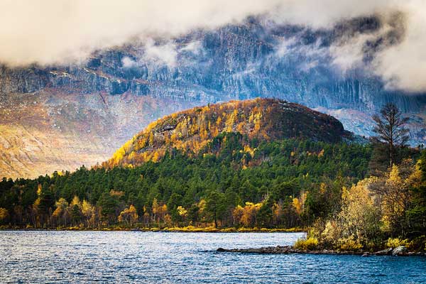
The Kungsleden scenery is diverse and dramatic. The region is home to high peaks, birch and old coniferous forest, bleak mountain fells, lakes and wetlands meaning that hikers will traverse through a variety of changing landscapes.
Seasonal changes are equally dramatic. From long summer days and short winter nights with snowy surface and dancing Northern Lights.
The highest point on the Kungsleden is the Tjäktja Pass, reaching an elevation of 3,770 ft.
Wildlife and Plants
If you are lucky you may spot the tracks (or the animals themselves!) of the Swedish Big Four - lynx, wolverine, bear and wolf - but you are most likely to encounter moose, elk and lemmings.
The area has an abundance of bird life, with roughly half of Sweden’s 400 bird species being spotted here.
The plant life along the trail is more vibrant in lower altitude areas and the vegetation can be organized according to altitude - namely pine forest, birch forest and mountain tundra.
Hiking
Covering 440 km in total, the Kungsleden has amazing adventures to offer, no matter the time of year.
The hike can easily be done in sections, and if you do not want to do the entire Kungsleden, you can easily do parts of it according to your preference.
The northern section of the Kungsleden trail is the most popular, but there is definitely no ‘bad’ part of this awe-inspiring hike.
Best Kungsleden Hikes
1. Abisko – Nikkaluokta

Photo by Stefano Paradisi
- Area: Northern section of Kungsleden
- Permit: No permits are required
- Difficulty: Moderate to difficult
- Distance: 105 km
- Elevation Gain: 2 500m total climb
- Time Hiking: 3 - 7 days
- Best Time to Hike: July to September
Route Description
This section of the Kungsleden is most popular and is frequented by hikers in both winter and summer. Along this section you will journey through the birch forests of Abisko National Park, as well as up the Tjäktja Pass - which is the highest point on the Kungsleden.
The distances between the STF cabins on this section vary between 12 and 20 km apart, with 6 huts in total.
If you choose to hike a cabin a day your total journey would take about a week, but you can choose to skip cabins. If you wanted to do this section in as little time as possible, you could aim to hike 35 km a day over a three day period.
Technically, the hike from Singi to the village of Nikkaluokta is not part of the Kungsleden, but it is a popular addition. If you would like to only hike this section of the Kungsleden, you can exit at the village. If you do not want to add this section in you can continue straight from Singi to Kaitumjaure.
Accommodation (STF cabins)
If you are planning to hike from hut to hut per day, your journey will go as follows.
- Day 1: Abisko to Abiskojaute
- Day 2: Abiskojaute to Alesjoure
- Day 3: Alesjoure to Tjäktja
- Day 4: Tjäktja to Sälka
- Day 5: Sälka to Singi
Optional
- Day 6: Singi to Kebnekaise
- Day 7: Kebnekaise to Nikkaluokta (village)
Abisko – Nikkaluokta Pro Tips
- Remember to show respect for the Sami people as they tend to their reindeer in this area.
- This is the busiest area of the Kungsleden, so if you are after isolation this may not be the route for you.
- If you are planning on camping remember the nights are cold throughout the year, so pack accordingly.
2. Nikkaluokta – Vakkotavare

Photo by Andre M.
- Area: Northern section of Kungsleden
- Permit: No permits are required
- Difficulty: Moderate to difficult
- Distance: 71 km
- Time Hiking: 3 to 6 days
- Best Time to Hike: mid-July to September
Route Description
If you decided to hike from Singi to Nikkaluokta, you will have to hike the returning trip to Singi. However, if you decided to skip Nikkaluokta you will hike south towards Vakkotavare. If you want to begin your Kungsleden hike at this point, you will have to start at Nikkaluokta.
This part of the Kungsleden crosses barren mountain landscape, moorland, birch forest and heaths. At the Lake Dievssajávri (Teusajaure) you will have to cross either by borrowing a rowing boat or you can pay to cross on a scheduled motor boat.
Accommodation (STF cabins)
If you are planning to hike from hut to hut per day, your journey will go as follows.
Optional
- Day 1: Nikkaluokta to Kebnekaise
- Day 2: Kebnekaise to Singini
Kungsleden
- Day 3: Singini to Kaitumjaure
- Day 4: Kaitumjaure to Teusajaure
- Day 5: Teusajaure to Vakkotavare
Nikkaluokta – Vakkotavare Pro Tips
- Vakkotavare mountain cabin is next to the bus stop along the road. You can journey to Saltoluokta mountain station by taking a bus and then catching a boat.
- Be prepared for all kinds of weather, no matter the season.
- If you are hiking in summer, pack in mosquito repellent as they can be a pest.
3. Saltoluokta – Kvikkjokk

Photo by Dennis Berggren
- Area: Northern section of Kungsleden
- Permit: No permits are required
- Difficulty: Moderate to difficult
- Distance: 73 km
- Time Hiking: 3 to 4 days
- Best Time to Hike: mid-July to September
Route Description
The first day of this hike is a long 20 km hike between Saltoluokta and Sitojaure. The hut here is located by a lake which has to be crossed the next day.
You can either row across or opt to pay for the speed boat to take you and there are multiple places on this section of the Kungsleden which have to crossed by boat.
This is one of the most spectacular parts of the trail is between Sitojaure and Aktse, where you will have an amazing views of the the Sarekfjällen mountains and Rapadalen valley.
Accommodation (STF cabins)
If you are planning to hike from hut to hut per day, your journey will go as follows.
- Day 1: Saltoluokta to Sitojaure
- Day 2: Sitojaure to Aktse
- Day 3: Aktse to Pårte
- Day 4: Pårte to Kvikkjokk
Saltoluokta – Kvikkjokk Top Tips
- Part of the trail in this section goes through the Sarek National Park, which has its own set of rules and regulations. Please check the park's official website for more information prior to your trek.
- Reindeer husbandry is practiced in this area of the Kungsleden, so be respectful of the herders and animals.
- Be careful if there is rain, as parts of the trail can become slippery.
4. Kvikkjokk - Ammarnäs

Photo by Henrik Andersson
- Area: Middle section of Kungsleden
- Permit: No permits are required
- Difficulty: Difficult
- Distance: 179 km
- Time Hiking: 7 - 10 days
- Best Time to Hike: August to September
Route Description
This part of the Kungsleden is the least travelled, and this section is also the least maintained part of the route and not all rivers will have bridges.
The hiking in this section of the trail is challenging as the path crosses numerous mountains and valleys.
Accommodation
There are no huts along this section, so a tent will be needed for this section of the trail.
Kvikkjokk - Ammarnäs Top Tips
- There are small mountain villages where you can look for accommodation and supplies.
- Although some of the rivers don’t have bridges they may be privately owned taxi boats that you can pay to cross.
- There are some basic forms of accommodation on this route, not run by STF - but you will still need a tent as these are few and far in-between.
- The winter route is not fully sign posted.
5. Ammarnäs - Hemavan

Photo by Stefan
- Area: Southern section of Kungsleden
- Permit: No permits are required
- Difficulty: Moderate to difficult
- Distance: 78 km
- Time Hiking: 5 to 7 days
- Best Time to Hike: Mid July to September
Route Description
This is the southernmost section of the Kungsleden trail. The trail can be hiked in either direction although many people chose to start in Ammarnäs.
Along this section of the Kungsleden you will be exposed to heathland and swallow valleys, as well as birch forest and moorland.
Accommodation (STF cabins)
If you are planning to hike from hut to hut per day, your journey will go as follows:
- Day 1: Ammarnäs to Aigert
- Day 2: Aigert to Serve
- Day 3: Serve to Tärnasjö
- Day 4: Tärnasjö to Syter
- Day 5: Syter to Viterskalet
- Day 6: Viterskalet to Hemavan
Ammarnäs - Hemavan Top Tips
- The first day is a short section but the terrain is steep so make sure you have the correct hiking boots.
- There are reindeer herders in this area so hikers are reminded to show them the appropriate respect.
- The small lakes along the way are great for fishing and swimming - if you can brave the cold.
Kungsleden Trail Map

If you are looking for clear and concise information on the Kungsleden we recommend Plan and Go: Kungsleden by Danielle and Wayne Feton.
There is also Trekking Beyond: Walk the world's epic trails book, that provides a good overview of a number of European treks.
Although they are online maps available, we recommend the maps produced by Calazo, as they are lightweight, compact and water-and-tear resistant, making them ideal for hikers.
The total Kungsleden requires four maps: Ammarnäs to Hemavan, Kvikkjokk to Ammarnäs, Sarek and Padjelanta, and Kebnekaisefjällen.
If you do not want to purchase maps you can also make use of the Landmateriat website, where you can easily select and print out sections. Alternatively, you can use the GPS app, Swedish Mountain Maps.
Video Overview
Cody Duncan went hiking the Kungsleden Trail, in Sweden. He filmed this video in September 2012 while hiking the northern section of Sweden's Kungsleden trail from Nikkaluokta to Abisko.
Kungsleden Trail - What You Ought To Know
Best Time To Go
The Kungsleden can be hiked at any time of year, each time having their own pros and cons. August is the busiest time of year as this is when many Europeans and Swedes take their summer holiday.
It's a good idea to check the weather before going on this hike.
Difficulty
The difficulty level is moderate-to-difficult and really depends on what you are doing and your level of fitness. The options on the Kungsleden are endless, as you can take the hike at a more leisurely pace and hike from hut to hut (roughly 12 to 13 km a day) or you can choose to skip huts and travel further distances each day. You can even choose to trail run the route and cover 110 km in as little time as a few days.
Permits
You do not need a reservation or a permit to hike the Kungsleden, but if you plan on staying in the huts along the way you will have to pay for these. The Swedish Tourist Association (STF) operates a series of huts across the mountains in Sweden which depend on those that use them to care for them. You do not have to be a member of STF to use the huts but it does make it cheaper.
Kungsleden Hike FAQ
Do I need a guide to hike the Kungsleden?
What are the huts along the Kungsleden like?
What gear do I need?
Do I need to take my own food and water?
What wildlife can I see when I hike the Kungsleden?
Browse more hikes in Europe
See our top European hikes picks, or check out these popular hikes.

