The West Highland Way Hike takes you on a journey through Scotland's spectacular highland landscape.
It's a 96 mile adventure from Milngavie to Fort William, filled with lovely Scotland (see United Kingdom hikes) scenery that encompasses quiet lochs, impressive mountains, flowing rivers and much more!
If you're interested in taking on this world-famous long distance hiking trail then have a look through this comprehensive guide to find out everything you need to know about the West Highland Way Hike.
West Highland Way Overview
Scotland's West Highland Way Hike is one of the most famous long-distance walks in world. Now, how long is the hike? The trail is 96 miles (154 km) in length and runs from Milngavie, in Glasgow, all the way to Fort William in the heart of the rugged region of Highlands.
Established in 1980, the West Highland Way was Scotland's first long distance hiking trail and is now a part of the International Appalachian Trail. For the US Appalachian Trail see this page.
The trail is an incredible adventure through Scotland's diverse scenery that gets more and more striking as you travel further into the hilly highlands.
From the tranquil shores of Loch Lomond to the wilds of Rannoch Moor and the striking, natural beauty of the Scottish Highlands, the West Highland Way Hike is a scenic paradise.
West Highland Way Quick Facts
- Elevation: 1800 feet (550 meters)
- Difficulty: Moderate - difficult
- Length: 96 miles (154 km)
- Duration: 5-9 days depending on preference and pace
- About 15,000 hikers walk the entire trail every year
- Opened in 1980
- The first long-distance hiking trail in Scotland
- You can climb Ben Nevis from Fort William

How Fit Do You Need To Be To Hike The West Highland Way?
The West Highland Way hike is a long and fairly challenging trail but it can be done with an average level of fitness. The northern sections in the Highlands are more challenging but the elevation is only about 1800 feet (550 meters). You don't need to be an experienced climber to take on the trail.
While the trail can be completed in about 5 days, it's recommended to plan your route for a 7 or 8 day journey. Most tour operators follow a specific itinerary that requires walking an average of 12 miles (19km) a day.
Unguided Vs. Guided West Highland Way
Most people opt to do a self-guided walk organized by a tour operator so there is minimal planning involved.
Many tour operators offer self-guided explorations of the West Highland Way hike where they will sort out your accommodations and luggage transfers so you just have to worry about your daypack.
This is the most popular option as the operators generally know the best places to stay and can provide any help should anything go wrong.
The other options are to either get yourself a guide book and plan out your whole route on your own or to do an organized guided trip with fellow hikers and a guide who will provide plenty of information on the history, flora and fauna of the land.
West Highland Way Route Description
People generally start the trail from the southern end in Glasgow and travel northward to Fort William because the southern sections are easier and will help prepare you for the more difficult terrain in the northern sections.
The trail begins at Milngavie, in the north of Glasgow, from where you will journey though the lowland, Scottish countryside to the scenic Conic Hill overlooking Loch Lomond.
You will then make your way along the serene shores of the loch, which is a largest freshwater loch in Great Britain, all the way to Inverarnan.
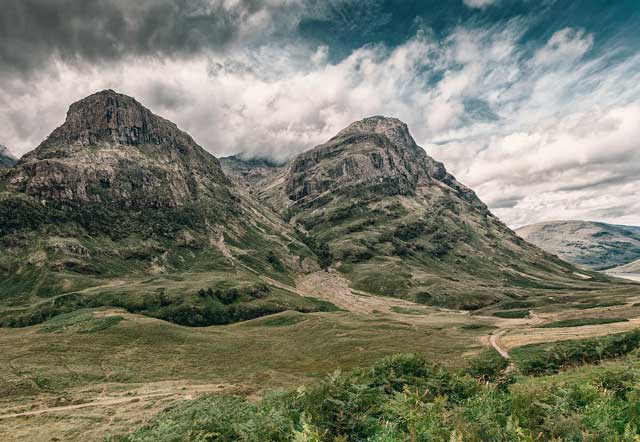
After you pass the small village of Tyndrum, the land becomes far more secluded as you pass through Rannoch Moor. From here you travel to the famous village Glencoe.
This is considered to be one of the most beautiful areas in the country surrounded by steep mountains with waterfalls and untamed flora. The route becomes more challenging in the Highlands as there are multiple steep sections to climb.
The final stretch begins with quite a steep and strenuous climb out of the village of Kinlochleven and the Mamore Mountains, which leads onto an old military path to Glen Nevis and finally Fort William.
Optional Add-On
Fort William is a picturesque Scottish town situated on the shoreline of Loch Linnhe. From here, many people go on to climb Ben Nevis - the highest mountain in Britain.
After you finish the West Highland Way hike you could spend some time in Fort William where you can catch the spectacular Jacobite steam train, which was used in the Harry Potter movies, for a magically scenic train journey!
Please Note
While there aren't any dangers or risks to worry about along the West Highland Way trail, there are ticks that carry Lyme disease, so despite the chances of infection being very low, it is still highly recommended to check yourself for ticks every day and take a tick-removal device with you. If you notice a swollen, red bite then seek medical attention.
West Highland Way Map
The West Highland Way hike usually begins at the southern end of the route in Milngavie, Glasgow. From there it travels north, typically through Drymen, Balmaha, Rowardennan, Inverarnan, Tyndrum, Inveroran, Glencoe, Kinlochleven and finally reaches Fort William.
No products found. by Long Distance Guides and by Bob Aitken.
This latest edition of the official trek guide has updated recently and now includes recent modifications to the way, and even provides a folding map.
To avoid getting your book soaked in rain, it comes with a useful plastic wallet for practical storage on-route.
West Highland Way Itinerary
Your itinerary will depend on whether you book through a tour operator or organize your route by yourself. Here is the general route and itinerary that most people take.
Milngavie to Drymen (12 miles/19km)
Drymen to Rowardennan (14 miles/22.5km)
Rowardennan to Inverarnan (14 miles/22.5km)
Inverarnan to Tyndrum (12 miles/19.5km)
Tyndrum to Inveroran (9 miles/14.5km)
Inveroran to Kingshouse (10 miles/16km)
Kingshouse to Kinlochleven (9 miles/14.5km)
Kinlochleven to Fort William (16 miles/24km)
Video Overview
Marc Kaiser walked the beautiful West Highland Way in Scotland (2016). 154km from Glasgow to Fort William. Enjoy the drone video footage of the West Highland Way!
Preparing for West Highland Way
When is the best time to trek West Highland Way?
The best time to do the West Highland Way hike is during the spring and autumn seasons when temperatures are more moderate.
However, weather can change drastically and unpredictably in the Highlands so you should pack for all types of weather regardless of when you choose to go.
May and September are very popular months to go because there are less midges around. Midges can be quite annoying because their bites are often very itchy.
You can walk the West Highland Way at any time of year, but you may be bothered by midges in the summer months (June to August).
Winters are lovely and quieter but very cold and you may encounter some snow and rain along the way.
Many tour operators do not offer tours during the winter months, so you would have to plan out your whole hike on your own.
How difficult is West Highland Way?
The West Highland Way hike is a moderate to difficult trail. It starts out with fairly easy, flat sections and becomes more difficult as you journey into the Highlands.
The total elevation isn't very high so you don't have to be an experienced mountaineer or climber to successfully do the trail.
There are some very steep sections which are quite difficult, but it can be done with an average level of fitness.
If you choose to take more days to do the West Highland Way hike in, it'll make the journey easier as you'll walk shorter distances every day.
Frequently Asked Questions
What gear do I need for West Highland Way?
What should I wear on the trek?
Can I camp along the West Highland Way trail?
Can I cycle the West Highland Way?
Are dogs allowed?
What wildlife could I see on the Way?
Browse more hikes in Europe
See our top European hikes picks, or check out these popular hikes.
