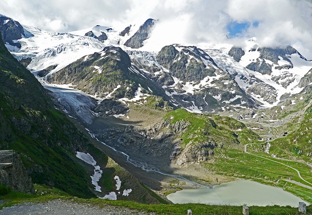
With ten peaks reaching higher than 4,000 meters, the Monte Rosa massif is one of the most impressive in the Alps. It is fair to say that the 9 day Tour de Monte Rosa trek, around the massif, is one of the best hiking routes in Europe.
The hike provides an epic mixture of awesome mountain-scapes across two great European states.
From hushed mountain passes to green valleys dotted with wooden Swiss Chalets during the first half of the hike, to the tranquility of remote Italian mountain villages during the latter stages of the trek, the Tour de Monte Rosa provides a great alternative to the Tour du Mont Blanc.
But do be aware, despite being one of the most scenic treks in the Alps, the route is strenuous, particularly the 3,295m high crossing of the Theodul Pass!
Join a Matterhorn Highlights Hike
Book with our recommended local guide
Tour de Monte Rosa Overview
The Tour de Monte Rosa is a long, multi-day hiking trail covering a total distance of 162 kilometers and gains more than 13,000 meters of altitude over 8 to 10 stages.
The highest point reached on the hike is 3,295 meters.
Most people start their hike in Täsh, Switzerland going in an anti-clockwise direction. Resting just to the east of the Matterhorn, the stunningly beautiful Monte Rosa is situated at the border between Switzerland and Italy.
The Tour de Monte Rosa provides a perfect opportunity to experience the different valleys in both countries.
On the circular hike you will pass some heavily glaciated areas, be afforded many scenic views of the highest peaks in Switzerland and take on some of the highest mountain passes in the Alps. The route will bring you to famous towns such as Zermatt, Aosta and Saas Fee, while crossing the notorious Europaweg.
You may also like: hiking in Switzerland
Tour de Monte Rosa Pros & Cons
Here's what we like and dislike about the Monte Rosa hike.
Pros
Cons
Monte Rosa Hike Route Map
This map illustrates the Tour de Monte Rosa.
Most people start their hike in Täsh or the Saas Fee.
The route is normally done in an anti-clockwise pattern but if you want to make the route a little easier then a clockwise plan is better as the ascents are more gradual.
You will need to cross Theodul Pass (3,295m), which is one of the highest passes in the Alps.
For an excellent guidebook and map we recommend Hilary Sharp's The Tour of Monte Rosa: A Trekker's Guide.

Monte Rosa Trail Altitude Profile
In the chart below you can see the altitude profile of the full hike. It is quite clear there is a lot of altitude to be gained over the stages. The heighest point is 3,295 meters. You can see that there are a few strenuous stages reaching high mountain passes that will require great effort.

This profile was produced by Trace de Trail and shows the altitude profile for the hike as well as the ultra marathon!
Join a Matterhorn Highlights Hike
Book with our recommended local guide
Tour de Monte Rosa Itinerary
Below we have laid out the most popular version of the Tour de Monte Rosa route – 9 days, starting and finishing in Saas Grund. The itinerary includes approx. distances, hiking times and elevation changes.
Day 1: Saas Grund – Macugnaga
Day 2: Macugnaga to the Rifugio Pastore
Day 3: Alagna to Col d’Olen
Day 4: Col d’Olen to Resy
Day 5: Resy to the Matterhorn!
Day 6: Theodul Pass – Zermatt
Day 7: Zermatt to the Europahutte
Day 8: Europahutte to Grachen
Day 9: Grachen to Saas Grund
Join a Matterhorn Highlights Hike
Book with our recommended local guide
Tour de Monte Rosa FAQ
When is the best time to trek the Tour de Monte Rosa?
The best time to tackle this high-level trek around the Monte Rosa massif depends on the amount and timing of the previous winter’s snowfall and the onset of cold weather in the autumn.
Since the route crosses high passes (Theodul at 3295m), snow can create dangerous conditions. Therefore in a normal year it is not advisable to set out before early July.
In the summer months, July and August, the trail is busiest, temperatures can rise to 25 degrees, but thunderstorms or a dump of snow is possible as well.
By the end of September huts will close and it might get a lot harder to complete the trek.
How much does the Tour de Monte Rosa trek cost?
Guided trekking tours of the Tour de Monte Rosa will cost in the region of $1,500-$2,000.
This will include mountain hut accommodation, food throughout the trek and luggage transfers between each stage, which will allow you to enjoy the hike with just a small backpack. You will also be accompanied by an experienced guide.
The trek can however be done unsupported. The cost would be in the region of $1,000. A DIY trek would mean carrying more weight in your backpack and some planning of logistics in the weeks / months before.
How difficult is the Tour de Monte Rosa trek?
Hiking the Tour de Monte Rosa is strenuous and demanding. Make sure your are physically and mentally fit for the trek. There are many steep, uphill sections to conquer, with over 13,000m of altitiude gained throughout the circuit. You need to ensure you are in shape for the physical demands of this route. Mental fitness is as important and often go hand in hand.
The Tour de Monte Rosa is doable for any fit mountain walkers who are able to hike between 5h and 8 hrs per day for several days in a row.
Please note: there are a few sections where you can use public transport to shorten your hike if you are struggling.
Are permits needed for the Monte Rosa trek?
No permits are required to the Monte Rosa circuit trek.
Is altitude sickness a risk on the Monte Rosa trek?
No, you will not cross passes any higher than 3,300 meter, and since you’re hiking slowly to this altitude, you have more than sufficient time to acclimatize.
Most people don’t feel any symptoms of altitude sickness before reaching 3000-3500 meter. But this is when they haven’t spent enough time acclimatizing.
What gear do I need for the Monte Rosa?
To do a serious hike like the Tour de Monte Rosa you will need appropriate layered clothing, including a warm insulated jacket and a hard shell waterproof layer.
Some comfortable lightweight trekking boots are a must to enjoy this trek, while good waterproofs are essential, not only to protect you against rain or snowfall but to double as windproofs. Since you’ll be crossing passes of more than 3000 meters, gloves and several base / second layers may prove useful. Trekking poles are a good way to not overload your knees and ankles.
If you are hiking unsupported you will need to carry a 50-60L backpack, however, if you plan to join an organised tour then many organisations will often include luggage transfer to your next accommodation in the valley, so you only need to carry a small backpack with some lunch, snacks and clothes.
A good three season, preferably four season sleeping bag is a must!
To help you plan and prepare for your trek we recommend reading our gear section.
Browse more hikes in Europe
See our top European hikes picks, or check out these popular hikes.

Hello!
Thanks for the info above. I’m planning on self guided walk in July. I’ve done a lot of hiking but new to the alps. Is saas-fee – Macugnaga a fairly manageable 30km first day? Seems too short to stop at Britannia Hutte after only 10km.
Thanks!
Bella
Hi Bella, thanks for getting in touch. I’m not 100% sure as the person who wrote this guide has left Mountain IQ. I recommend checking out this website for self-guided help: https://www.thehiking.club/
Hi. Great site. Thanks for offering help. If I fly in to Milan and have 6 hiking days, what are suggested routes? [Beginning August. Dad & Grad (son graduating high school). Fitness – I run marathons, he runs half marathons. We had a great 4 day hut to hut experience in Switz/ Bernese Oberland a few yrs ago.] I assume we can’t do full circuit. Is that right? Thank you!
HI Tagrey, see our answer to Michael Wirth below. Cheers!
I am wondering if there is a possibility of shortening the trip and what your recommendation would be to do such.
I remember I ended the trek at Staffal (Gressoney-La-Trinité) and traveled with public transport to Milan. I liked the part crossing Theodulpass so my advice would be to follow the route clock-wise towards Zermatt. This would take 3-4 days, so you could hike further along the Europaweg towards Sint Niklaus as well, adding two extra days.
If you have mountaineering aspirations or just want some bragging rights 😉 you can climb Breithorn along the way from Klein Matterhorn. This is an easy 4000 meter peak, which requires crampons and ice axe though, but only takes 3 hours. It gives you awesome views on Matterhorn and Monte Rosa massif.