The Gosainkunda trek is one of the shortest treks in Nepal and a relatively easy hike.
However, altitude sickness is still a problem, although less of a risk than on some other major treks in the region such as the Langtang hike.
On this page, you will find a comprehensive and impartial guide to the Gosainkunda trek.
Gosainkunda Trek Overview
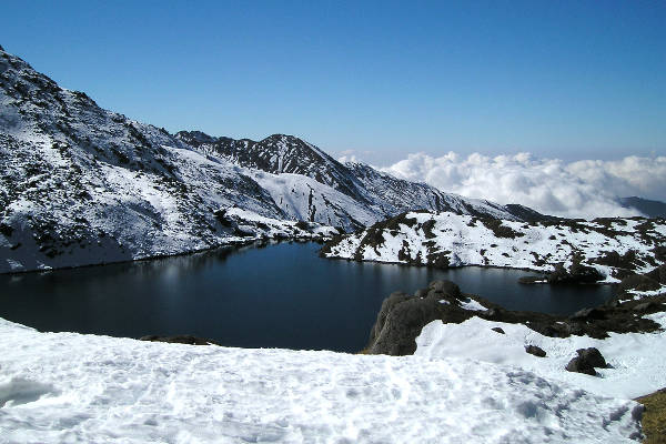
The Gosainkunda trek takes hikers to one of Nepal’s most beautiful lakes of the same name, located 14,374 feet above sea level.
According to legend, it was formed when the Hindu god, Shiva, pierced a glacier with the trishul, his trident, so he could obtain water after he swallowed poison that made his throat turn blue and sting.
People have often claimed that they could see Shiva asleep in the water. If so, he is one of the few lifeforms present in the lake. This lake is oligotrophic – low in nutrients. As a result, there are few fish and little algae, the latter making the waters very clear and eminently drinkable. Gosainkunda Lake is 40 square miles in size and there are around 108 other lakes in the vicinity.
The lake is now a pilgrimage site for Buddhists and Hindus, with the peak period being the full moon festival of Janai Purnima in August, when over 25,000 visit the lake! It is believed that bathing in the lake will wash away one’s sins. There is much dancing at the fesrival. Shamans demonstrate their skills to teachers to qualify for the post of village shaman. Sadly, many pilgrims fall prey to altitude sickness, having climbed too fast. Dehydration can also make the situation worse if they are fasting.
The inhabitants of the Gosainkunda area are mostly Tamangs. The Tamang people constitute 5.6 percent of the population of Nepal and have their own language.
The highlight of this Gosainkunda hike is sunrise at Laurebina, where there is a panoramic view of Langtang ridge. This is the sunrise of a lifetime. At 15,120 feet, this is the highest point you will reach.
Hiking to Gosainkunda can take anywhere from 8 to 16 days, depending on how pressed for time you are.
Regional Map
The Langtang region, where Gosainkunda is located, is a stone’s throw north of Kathmandu. The lake is the source of the Trishuli River.
It is frozen in winter, from December to February, although this period is growing shorter due to climate change.
On a clear day, the Annapurna range can be seen to the north.

Recommended Map
Unfortunately, no paper maps have been published for the Gosainkunda Trek.
The only book dedicated to Gosainkunda Lake is Application of GIS In Bathymetric Mapping of Gosainkunda Lake by Sudip Raj Niroula. This book discusses the lake’s morphometry (shape, size, volume and depth) and could be slightly overwhelming for trekkers.
Gosainkunda Hike Itinerary
In this itinerary, accommodation is entirely at tea houses. Please note that there are several Gosainkunda trek itineraries that can be done. Below we have laid out the most popular version – 10 days, leaving from Kathmandu. If you want to make your own way to Dhunche then you could probably organise an independent hike with a guide.
Day 1-2
You arrive in Kathmandu. Kathmandu overflows with attractions such as Durbar Square, whose temples date to the 12th century, Boudhanath Stupa, one of the largest in the world, and the Pashupatinath Temple, the most important Hindu temple in the country.
")
Day 3
Your first move is a drive to Dhunche, which takes roughly eight hours by bus. As you go, there is a view of majestic mountains that include Ganesh Himal. Dhunche is a pleasing village containing large stone houses.
Day 4
Your trek begins today. You start by walking up through forests of oak, fir and the beautiful rhododendrons. When you arrive in Sing Gompa, you find a monastery and a cheese factory that employs yak milk. You have a good view of Langtang Himal and Langtang Valley on the way.
Day 5
You ascend up through forest once more, eventually arriving in Gosainkunda where you stay for the night. Visible are the mountains of Dorje Lakpa, Ganesh Himal, Langtang and Langtang Lirung.

Day 6
The trail continues upwards. The path is quite rough and eroded. Moraines – patches of dirt and rock – are crossed. Laurebina La pass is also to be crossed. Next, you descend to Phedi. The path ascends once again before descending down among rocky hills and pine and rhododendron forest. You arrive in Ghopte where you stay for the night.
Day 7
The trail now descends along a ridge, with forest to either side. You ascend to Tharepati, with a stream en route. Tharepati is in the lap of the mountain. You spend the night here.
Day 8
You climb to a ridge above the village and enter a forest. You follow the Melamchi River and ascend to Melamchi Goan. You arrive in the village of Tarkeghyang where you stay the night.

Day 9
After crossing a small forest, the trail leads to the small and beautiful village of Gangwal. There is a small monastery here. Your next stop is Sermanthang, another very pretty village.
Day 10
It is a short way down to Malamchi Pul Bazaar. You board a vehicle to return to Kathmandu.

Gosainkunda Hike FAQ
How much does the Gosainkunda trek cost?
Prices for the Gosainkunda Trek range from $650 on the low end to $1,500 on the top end. We recommend you go with a tried and trusted company. Check out our guide on finding the best trekking company in Nepal.
Are permits required for the Gosainkunda trek?
Yes, you require permits for the Gosainkunda trek. You need to purchase a Langtang National Park Entry Permit (which costs $30) and a Trekkers Information Management System registration (which costs $10 when procured through a company $20 as an individual).
When is the best time to trek Gosainkunda?
The best time to hike to Gosainkunda is autumn (mid-October to mid-December). Please keep in mind that Laurebina Pass may remain closed until early May.
Learn more about when to hike in Nepal.

Is altitude sickness a risk on the Gosainkunda trek?
Yes, there is a risk of altitude sickness on the Gosainkunda trek as it ascends to some high-altitude points. At its highest point, Laurebina, you will reach an altitude of 4,610 meters (15,120 feet).
How difficult is the Gosainkunda trek?
The Gosainkunda hike is considered moderately difficult, and a good level of fitness is required. There are steep sections, and you will be trekking for some miles each day.
Are there any recommended guidebooks for the Gosainkunda trek?
In terms of a guidebook, we recommend No products found. by Sian Pritchard-Jones, Bob Gibbons and the Himalayan Map House.

Are there other Nepal trekking routes?
Yes, there are plenty of other Nepal trekking routes to explore. I recommend checking out the Gokyo Lakes hike or see more options below.
Continue browsing
See more information on Nepal. Or check out these other Nepal hiking articles:
