Close to the Grand Canyon and Zion National Park, the Bryce Canyon is an area you simply cannot miss. With its towering hoodoos, and awe-inspiring rock formations, exploring the canyon should definitely be on your hiking bucket list.
We've put together this list of the best Bryce Canyon hikes so that you can make the most out of your visit.
Here are my Best Bryce Canyon Hikes (Day Hikes):
- Navajo Loop Trail
- Queen’s Garden Trail
- Peek-A-Boo Loop Trail
- Bristlecone Loop Trail
- Fairyland Loop Trail
- Mossy Cave Trail
- Bryce Canyon Rim Trail
Best Bryce Canyon Hikes
1. Navajo Loop Trail

Photo by Ronan29
- Area: Bryce Canyon Amphitheatre, Sunset Point
- Permit: No, but you will need a 7 day pass to access the park.
- Difficulty: Moderate
- Distance: 1,3 miles round trip
- Elevation: 550 feet
- Time Hiking: 1 - 2 hours
- Best Time to Hike: April - October
Route Description
Possibly the most popular of all the Bryce Canyon hikes, the Navajo Loop Trail begins at Sunset point and makes its way down the canyon.
You will pass through narrow corridors, and the Silent City (a huge number of hoodoos and spires) before reaching the Queen’s Garden intersection. Note that the hike includes a steep climb down, and then back up the canyon.
If you feel the Navajo Loop is too short, you can easily connect it to the Queen’s Garden for a longer, more varied loop. You can also connect the Peek-a-boo loop and both these trials will give you a 6.3 mile figure eight loop.
Accommodation
Sunset campground is closest. However, you can also find accommodation in the North Campground and the Bryce Lodge.
Hidden Falls Trail Pro Tips
- Lightning can be a safety hazard in summer, so take note of any possible storm before setting out.
- As it is the most popular hike, you can expect the path to be relatively busy.
- Be aware of loose rocks and rock slides. The largest number of rock falls occur of this trail, so caution is advised.
- There are portions of the trail that have no shade, so in summer it can get really hot.
- Remember to stay hydrated (especially in summer), it is a good idea to aim to drink 1 litre every hour.
2. Queen’s Garden Trail

Photo by rosinberg
- Area: Bryce Canyon Amphitheatre, Sunrise point.
- Permit: No, but you need a pass to access the park.
- Difficulty: Moderate
- Distance: 1.8 miles out and back
- Elevation: 320 feet (if you hike down and back)
- Hiking Time: 1 - 2 hours
- Best Time to Hike: The trail is fully accessible between April and November, but the best time to hike is early summer and fall, to avoid summer heat and winter snow.
Route Description
The Queen's Garden Trail is also a very popular choice among the various Bryce Canyon hikes. This trail is the easiest of the hikes that enter the canyon from the rim.
Beginning at Sunrise point, the path makes its way down a sloping ridge-line past famous hoodoo rock formations, such as Queen Victoria (where you can spot the queen if you use your imagination).
The route is not a loop, but rather an out-and-back. For this reason many people connect it with the Navajo trail to return along a section of the trail rim, or the Peekaboo loop, slightly further south.
The best viewing area on the trail are near the top of the Queen’s Garden Trail, where you will see a wide area of hoodoos the north and a closer formation of them to the south of you.
Accommodation
Sunset Campground, North Campground and Bryce Lodge. Bryce Canyon Lodge is probably the closest, but none of them are very far away.
Queen’s Garden Trail Pro Tips
- Can be quite crowded due to popularity, so plan your hike around peak times if you would like to avoid lots of people.
- Stay on maintained trails, don’t use ‘social’ trails that people have made along the way.
- The best time to hike is in the morning, as this way you avoid crowds and beat the heat.
- Dress in layers (especially if you have a start early) as it can be very cold in the morning and heat up quickly.
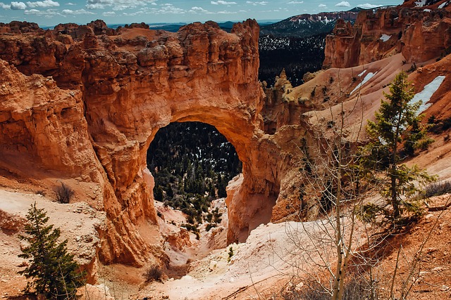
3. Peek-A-Boo Loop Trail

Photo by Bernard Kamerman
- Area: Bryce Canyon, Bryce Point
- Permit: No, but you will need a seven day pass to access the park.
- Difficulty: Strenuous
- Distance: 5,5 miles
- Elevation: 1138 feet
- Hiking Time: 1 and half to 2 and a half hours
- Best Time to Hike: Spring, early summer and fall
Route Description
One of the more difficult routes, the trail begins at Bryce point. When you start out you will have a panoramic view of hoodoo rock formations and the Tropic Valley.
Shortly after beginning you will descend quickly to the canyon floor, switch backing through hoodoo formations.
As the trail continues to wind its way down, you will reach a junction in the path. This is the beginning of the loop and it can be hiked in either direction.
If you travel in a clockwise direction, the beginning section undulating, followed by a steep climb at the end.
Accommodation
Sunset Campground, North Campground and Bryce Lodge. Sunset Campground is closest.
Peek-a-Boo Loop Trail Pro Tips
- This trail is shared with mules and horses, be courteous and give the riders right of way.
- Due to the steep inclines and declines, foot injuries are common - so make sure that you are wearing proper hiking boots.
- There is a restroom at the bottom of the trail, shared by both hikers and trail riders.
- Parking is limited, and is a big stop for the busses - so get there early.
4. Bristlecone Loop Trail

Photo by Mike Druckenbrod
- Area: Bryce Canyon, Rainbow Point
- Permit: No, but you will need a seven day pass to access the park. You will need a permit if you plan on staying in the backcountry.
- Difficulty: Easy
- Distance: 1 mile loop
- Elevation: 88 feet
- Time Hiking: plus or minus an hour
- Best Time to Hike: April until October
Route Description
Beginning at Rainbow point, the Bristlecone Loop winds through a forest containing Douglas fir, Blue Spruce and White fir.
The loop is named after the Bristlecone Pine, which is found most frequently along the trail - regularly living up to 1 800 years old, these trees are definitely something worth seeing.
Following the edge of the mountain, the loop takes you to the highest elevation in the park.
Being a shorter, easier option, the hike does not descend below the canyon rim - so it is an ideal Bryce Canyon hike if you are looking for something quicker and easier that still delivers amazing views.
Accommodation
Sunset Campground, North Campground and Bryce Lodge. If you want to camp in the backcountry, there is Riggs Spring group site along the Riggs Spring Loop.
Bristlecone Loop Trail Pro Tips
- During winter, it may be inaccessible due to think snow
- It may be colder here than other areas of the park - due to this reason, snow tends to linger.
- It may be a good idea to check conditions, prior to heading out. This was you can be prepared for whatever weather and temperature.
5. Fairyland Loop Trail

Photo by Anita Sagastegui
- Area: Fairyland amphitheatre
- Permit: No, but you will need a seven day pass to access the park.
- Difficulty: Moderate to Strenuous
- Distance: 8 mile round trip
- Elevation: 1,545 feet
- Time Hiking: 4 to 5 hours
- Best Time to Hike: April through to October
Beginning at the Fairyland point, in the more northern part of the park, the route takes you from the along the top of the rim to descending into the canyon. At roughly 1,5 miles in the hike reaches its lowest point.
Along the way you will have spectacular views of hoodoo formations, such as the China Wall (which is an impressive fence of hoodoos) and the Sinking Ship.
The hike is one of the longer and more difficult in the park, so it has less foot traffic along the along the way.
Accommodation
Closest campsite is the North Campground.
Fairyland Loop Trail Tips
- Watch out for snakes along the trail
- Be sure to take along enough water, being a longer and more strenuous hike you’ll drink more along the way.
- If you enjoy quiet hikes, you love the Fairyland Loop. As the hike is longer, it is more remote than the shorter more popular ones.
- If you start out early or late you may be lucky enough to spot deer along the way.
- Hike a little later and get the chance to see the Milky Way galaxy from the trail (but remember to take your head torch!).
6. Bryce Canyon Mossy Cave Trail
The Bryce Canyon Mossy Cave Trail is a beautiful and accessible hiking trail that offers some stunning views of the park. It is very short and easy, so it's a great option for families and novice hikers.
- Permit: No, but you will need a seven day pass to access the park.
- Difficulty: Easy and short, but with slippery stream crossings
- Distance: 0.8 mile
- Elevation: Low, 300 feet (91 meters)
- Time Hiking: Half an hour
- Best Time to Hike: April through to October
The highlight of the Mossy Cave Trail is a natural amphitheater with a waterfall and a moss-covered cave. It is most beautiful to see in spring and in summer. The trail also offers amazing views of the famous red rock formations. This is quite an easy and short hike (0.8 miles/1.3 km). So it is suitable for all skill levels, even families.
Pro Tips
- Trailhead: The trailhead for the Mossy Cave Trail is located at the far end of the parking lot at the north end of Bryce Canyon National Park. There is no fee.
- Conditions: The trail is generally well-maintained, but it can be rocky and uneven in places. You should wear appropriate hiking shoes.
- Wildlife: Deer, chipmunks, various birds
- Book accommodation in advance
7. Bryce Canyon Rim Trail
Rim Trail connects all the scenic overlooks from Fairyland Point to Bryce Point and is a very popular hike.
- Permit: No, but you will need a seven day pass to access the park.
- Difficulty: Moderate
- Distance: 5.5 miles (8.9 km) one way, but can be shortened
- Elevation: Max 7,775 ft (2370 m)
- Time Hiking: 3 hours
- Best Time to Hike: April through to October
The path swirls along the rim of Fairyland Canyon and Bryce Canyon (hence the name). Passing all the scenic overlooks, it connects Fairlyland and Bryce points. Accessible from the park road at multiple lookouts, the trail provides epic views of the canyons and spires in very photogenic red rock. Between Sunrise Point and Sunset Point is a well-maintained path that is mainly paved or flattened, so wheelchair hikers can trek some of it.
Bryce Canyon Hiking Map

Bryce Canyon is located in southern Utah, about 50 miles northeast of Zion National Park.
Although free information can easily be found in visitor’s centers and online, nothing quite matches up to having a hard copy on your hike.
We recommend National Geographic’s waterproof and tear resistant map of the Bryce Canyon National Park.
The map features area of key interest such as Rainbow Point, Ruby’s Inn and Natural Bridge.
Recommended Guidebook

For a fantastic book that covers not only the Bryce Canyon National Park, but also Zion National Park, Capitol Reef National Park, Canyonlands National Park and Arches National Park we recommend Zion & Bryce: Including Arches, Canyonlands, Capitol Reef, Grand Staircase-Escalante & Moab (Travel Guide).
The book will guide you along the way, not only to the Bryce Canyon hikes, but it will also give you strategies for getting to the other parks and travelling between them.
Definitely a handy guide if you plan on visiting more than just the Bryce Canyon.
Bryce Canyon Overview
Best known for its interesting, crimson colored hoodoo rock formations, its natural bridges and towering fins, Bryce Canyon is really a geological phenomenon to behold.
Due to its high elevation, winter can bring quite heavy snowfall - which is strange considering it’s in a desert! Covering a vertical distance of over 2 000 feet, there is definitely no shortage of awe-inspiring sights and spectacular hiking.
Bryce Canyon Quick Facts
- Due to the high air quality and distance from light pollution, the star gazing at Bryce Canyon is really spectacular.
- Bryce Canyon is home to Bristlecone pines, which are the oldest trees in the world. The oldest reaching the grand old age of nearly 5 000 years!
- The lowest recorded temperature is -29.0°F, which was recorded in a January.
- The canyon was settled by Mormon Pioneers in the 1850s, and was named after Ebenezer Bryce.
- Hoodoos (unique rock formations) can be up to 60 m high.
- More than 400 native plant species call the park home.
- Prime viewing time of the amphitheatre are around sunrise and sunset, with the two aptly named viewpoints (Sunrise and Sunset) being the best place to view them from.
Typography
Bryce Canyon’s rock formations are probably the reason over 1, 5 million people visit a year.
Hoodoo formations are large, irregular columns of rock and the largest concentration on Earth are found in the Bryce Canyon.
Unlike other canyons, Bryce Canyon is not formed by flowing water, but rather is formed by frost wedging - this is due to constant freezing and melting of water, as the temperature drops below freezing most nights of the year.
The most visited area of the park is the Bryce Canyon Amphitheater, as it contains many of the famous structures in the park.
There are four main viewpoints, namely Sunrise, Sunset, Inspiration and Bryce, where one can view the canyon.
Surprisingly, although being very close to Zion National Park, Bryce Canyon is very different in climate, topography and geology.
Wildlife and Plants
As the park transcends 2 000 feet of elevation, it exists in three distinct climate zones - namely juniper forest, Ponderosa Pine forest and spruce/fir forest.
Due to the diversity of habitat, many species of animals and birds call the alpine environment home.
The canyon and plateau are home to many different species of animals, from Pronghorn deer to Black Bear to the small Golden-mantled Ground Squirrel, the canyon will be a delight to any wildlife or bird enthusiast.
Bryce Canyon Hikes FAQ
Do I need a reservation to go on Bryce Canyon hikes?
No, but a backcountry permit is needed if you plan on doing any overnight hiking
How much are Bryce Canyon fees?
The following fees are for seven day permits.
- Individual Permit - $20
- Motorcycle Permit - $30
- Vehicle Permit - $35
The Bryce Canyon annual pass is $40 and gives access to unlimited visits in the park throughout the year.
When is the best time to visit Bryce Canyon?
The weather is best during June, July and August but this is also the time when the park sees its biggest crowds. April and October may be preferable if you plan on beating the masses.
Are the Bryce Canyon hikes difficult?
This depends on what hikes you choose to do, the hikes vary from difficult to easy but it is a good idea to be aware that any hikes that go below the rim will include steep climbs and therefore may be more strenuous.
Is altitude sickness a risk?
Generally altitude won’t be a risk, but this also depends from what altitude you have travelled to the park from.
Altitude sickness is a concern when you rapidly change from lower to higher altitude, the quicker and higher, the greater the risk.
As always, it is a good idea to stay hydrated and rest on the first day that you get to the park.
What gear do I need?
Use hiking boots with good traction and ankle support, especially if you are hiking below the rim, as you will experience steep declines and ascents.
It is always a good idea to have adequate sun protection, as even at colder, higher ranges the sun can still be very harsh.
Lastly, be aware that for about 200 days a year the temperature drops below freezing - so if you are hiking early or late (or even camping) come prepared for the cold.

Browse more US National Park hikes
See our picks for the Best Hikes in America, or check out these popular hikes.
