Looking for the best hikes in Yellowstone National Park?
Whether you wish to see the astounding geothermal features, impressive waterfalls, tranquil mountains, beautiful lakes, or breath-taking canyons, hiking in the Yellowstone will give you a great vantage point to see some the features that make this park so popular up close.
We have put together a list of the top Yellowstone hikes that you should consider when visiting the national park.
Best Yellowstone Hikes
To my mind, the best Yellowstone hikes are:
- Grand Prismatic Spring hike
- Uncle Tom's hike
- Fairy Falls trail
- Boiling River hike
- Mount Washburn trail
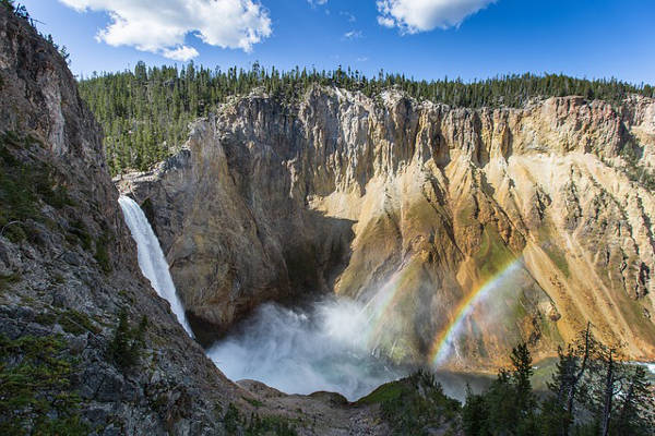
1. Uncle Tom's Trail

- Area: Canyon Village
- Difficulty: Strenuous
- Distance: 0.97km round-trip
- Elevation Loss: 152m
- Days/Hours: 1 – 2 hours
- Best Time to Hike: April - October
Route Description
Uncle Tom’s Trail is a short but strenuous descent down and then back up 328 metal steps to a viewpoint that overlooks the magnificent Lower Falls. Though not technically difficult in any way, the steps are steep and whilst it may seem easy on the descent, the walk back up can be strenuous. There are handrails for support and benches to rest on along the route.
Accommodation
Nearby accommodation at Canyon Lodge or Canyon Campground.
Uncle Tom's Trail Top Tips
- Make sure you have shoes with good traction as the metal stairs can be slippery when wet
- Make sure you have some water with you as the steep stairs can leave you feeling fatigued
- Look out for the information boards along the way for some interesting history about the route
2. Fairy Falls Trail

- Area: Old Faithful
- Difficulty: Easy
- Distance: short route 8.4km round-trip, long route 11.2km
- Bear Management Area: Yes. Trail opens late May
- Days/Hours: 2 – 3 hours on short route, 3 – 4 hours on long route
- Best Time to Hike: April - October
Route Description
A fairly flat and easy trail takes you through lodgepine forests to the spectacular Fairy Falls. For the short route park 1.5km south of the Midway Geyser Basin, cross the steel bridge and walk 1.8km to the trailhead. For a longer route, park and then start your 2.4km walk to the trailhead from the end of Fountain Flat drive. From the trailhead, you walk 2.4km through a lodgepole forest to the 61m high waterfall. Add another 1.9km to your hike and continue past the waterfall onto Spray and Imperial Geysers.
Accommodation
Nearby accommodation at Old Faithful Inn, Old Faithful Lodge, Old Faithful Snow Lodge or Madison Campground.
Fairy Falls Trail Tips
- Bear Management area, be on the lookout for bears and follow the stipulated safety precautions
- If you are feeling up for an even longer hike, then add in the Grand Prismatic Spring Trail
- Parking at the trailhead is limited so it is advisable to start your route from just south of Midway Geyser Basin or Fountain Flat drive mentioned above.
3. Grand Prismatic Spring Trail

- Area: Old Faithful
- Difficulty: Easy
- Distance: short route 5.5km round trip, long route 11.5km
- Bear Management Area: Yes. Trail opens late May
- Days/Hours: 1 – 2 hours, 3 hours long route
- Best Time to Hike: June - October
Route Description
This trail takes you up a gradual incline to Picture Hill for a spectacular view over Yellowstone’s colourful Grand Prismatic Spring and the Midway Geyser Basin. It starts and ends at the same points as the Fairy Falls trail and so distance can be tailored according to what you feel like seeing on your hike.
Accommodation
Nearby accommodation at Old Faithful Inn, Old Faithful Lodge, Old Faithful Snow Lodge or Madison Campground.
Grand Prismatic Trail Top Tips
- Do not forget your camera for taking snaps of this astounding hydrothermal feature
- Bear Management area, be on the lookout for bears and follow the stipulated safety precautions
- Vary the length of your hike by starting south of the Midway Geyser Basin for a shorter trail or at the end of Fountain Flat drive for a longer trail
4. Boiling River Yellowstone Trail

- Area: Mammoth Hot Springs
- Difficulty: Easy
- Distance: 2km round-trip
- Days/Hours: 1 hour
- Best Time to Hike: June – November
Route Description
A very flat and wide trail will take you from the trailhead to the point where the scalding Boiling River and cold Gardner River waters meet and mix to make an ideal swimming spot.
Accommodation
Nearby accommodation at Mammoth Hotel, and camping at Mammoth Campground or Indian Creek Campground.
Boiling River Trail Hike Tips
- Take the whole family on this gentle trail to the Boiling River bathing spot
- Swimming is open from 9am to 5pm daily
- Boiling River is sometimes closed to the public during Spring months if the river level is high
5. Mount Washburn Trail

- Area: North approach trail from Tower-Roosevelt and South approach trail from Canyon area
- Bear Management Area: Yes
- Difficulty: Strenuous
- Distance: 8km round trip on the North trail, 9.6km round trip on the South trail
- Elevation Gain: 425m
- Days/Hours: 3 -6 hours
- Best Time to Hike: May - October
Route Description
Mount Washburn is Yellowstone National Park’s most prominent peak at 3,107m. Both the north and south trails are a steady climb up to the peak which offers panoramic views over the National Park. There is a fire lookout station at the top where visitors can experience an interactive exhibit.
The north approach from Chittenden Road is known for its wildlife viewing along the route whilst the south approach from Dunraven Pass is also open to bicycles and park vehicles.
Accommodation
Nearby accommodation at Roosevelt Lodge and Tower Fall Campground for the north approach, and at Canyon Lodge and Canyon Campground for the south approach.
Mount Washburn Trail Tips
- High altitude climb – carry appropriate clothing to protect you against sudden possible changes of weather including rain and wind.
- Lightning is common in rainstorms, seek shelter below the treeline and follow the stipulated safety procedures.
- There is no access to water along the south approach from Dunraven so make sure you carry enough with you on your hike
Yellowstone Hiking Map
Yellowstone National Park lies on the Yellowstone Plateau within three U.S states – 96% of the land is in the state of Wyoming, 3% is within Montana, and the remaining 1% is in Idaho. It is nearly completely surrounded by the Rocky Mountains and part of it lies on the Yellowstone Caldera.
The Yellowstone National Park Service website offers downloadable maps of the different day hike trails. Otherwise, stop in at one of the ten visitor’s centres within the Park and speak to a ranger or No products found. for the surrounding areas hikes.
There are five entrances and the Park is divided into eight areas
- Canyon Village
- Fishing Bridge, Lake Village and Bay Bridge
- Madison and West Yellowstone
- Mammoth Hot Springs
- Norris
- Old Faithful
- Tower-Rooseveldt
- West Thumb and Grant Village
Please note: Day hiking does not require a permit but if you are carrying food then bear-resistant storage containers are a must and it is always advisable to carry bear spray.
Yellowstone Guidebook
For an awesome book of general things to do in Yellowstone National Park (and Grand Teton), hiking tails, backpacking trails and more, we recommend No products found..
Yellowstone National Park
Overview
Yellowstone is the first ever National Park to be established in the United States, and some say in the world as well.
It spans an area of 8,983 square kilometres across the U.S. states of Wyoming, Montana and Idaho and is a UNESCO World Heritage Site. Its large size allows for a vast range of activities for the outdoor enthusiast and it is open year-round, though with limited road access, for seasonal activities and visits.
Yellowstone Quick Facts
- 90% recommended wilderness area
- Average of 3.5 million visitors per year
- Home to Old Faithful geyser
- America’s first National Park
- The Park is larger than the states of Rhode Island or Delaware
- 1,449km of hiking trails
- Köppen climate Classification: Continental Subarctic Climate
- Yellowstone Caldera is North America’s largest active “supervolcano”
- Five park entrances – North entrance open year round, the other four only during season
- Camping and lodge facilities within the Park
Topography
The National Park has an average elevation of 2,400m above sea level and sits on the Yellowstone Plateau which is bordered on nearly all sides by the Middle Rocky Mountains.
The highest peak in the Park is Eagle Peak at 3,462m above sea level, though Mt Washburn at 3,122m is the most prominent peak and one of our recommended hikes. The lowest point is in Reese Creek at 1,610m above sea level.
There are three canyons in the park. The Grand Canyon of the Yellowstone which has been cut by the Yellowstone River after the Lower Yellowstone Falls is the oldest and Uncle Tom's trail will take you to a viewpoint in the canyon from where you can marvel over the sight of the 94m waterfall rushing down towards the earth.
Further downstream the Yellowstone River flows through the Black Canyon and in the south of the Park, there is Lewis Canyon which the Lewis River flows through.
The National Park is situated on North America’s largest active “supervolcano” caldera, the Yellowstone Caldera.
The resulting landscape is an impressive array of hydrothermal features such as geysers, hot springs, mud pots, fumaroles and travertine terraces.
These form part of the criterion why the National Park was named a World Heritage Site and three of our recommended trails, Fairy Falls trail, Grand Prismatic trail, and the Boiling River trail will get you up close and personal to these unforgettable wonders.
Wildlife and Plants
Yellowstone National Park is at the heart of one of the largest nearly intact temperate ecosystems in the world.
The diverse habitats in the Park mean that a variety of mammals, birds, fish, amphibians and reptiles flourish here.
Conservation efforts saw the introduction of a number of wild wolves into the Park in 1995, and it also is home to various other large mammals such as the grizzly bear, black bear, bison, elk, and moose to name a few.
Different vegetation types characterize the different levels of elevation within the Park. Forests make up 80% of the National Park and of that, lodgepole pine forests are the most common.
Other types of vegetation include wetlands, sagebrush and hydrothermal plant communities.
Frequently Asked Questions
Do I need a reservation to go on a Yellowstone hike?
How much are Yellowstone entrance fees?
When is the best time to visit Yellowstone?
Is altitude sickness a risk?
Are Yellowstone hikes difficult?
What gear do I need?

Browse more US National Park hikes
See our picks for the Best Hikes in America, or check out these popular hikes.
