Looking to hike one of Glacier National Park’s most popular day hikes?
Then the Highline Trail is perfect for you.
This guide will give you all the information you need for your journey along the Highline Trail.
Highline Trail Facts
- Total Elevation Gain: 1,950ft
- Difficulty: Strenuous
- Length: 11.4 miles
- Quickest Route: Via Logan Pass
- Highlights: Mt Cannon, Mt. Oberlin, Heavens Peak, Swiftcurrent Mountain, the Salamander Glacier, and Grinnell Glacier, the Garden Wall
- Another name: Highline Loop
Highline Trail Hike
Route Overview
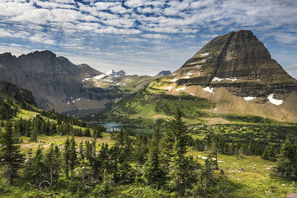
The Highline Trail is one of Glacier Parks’ most beautiful trails. It is most popular for its views along the Garden Wall. This is a wall that continues for 0.25 of a mile and is only 6-8ft wide. There are hand cables to guide you through this part of the trail. That way you can enjoy the stunning views without any obstructions.
This hike is often called the “Highline Loop” when in fact it is a one-way. For the most beautiful sea of wildflower, consider doing this hike in the summer. Catch a glimpse of Mt Cannon, Mt. Oberlin, Heavens Peak, Swiftcurrent Mountain, the Salamander Glacier, and Grinnell Glacier along this 11.4-mile trail all year long.
The Highline trail can be hiked all year round although it’s important to proceed with caution during the winter. The ground can be slippery and icy. You should avoid venturing off the trail for any reason. This can result in you walking on top of a snowfield that perfectly hides gaping holes.
The Highline Loop begins near Logan Pass. This is found on the north side of the iconic Going-to-the-Sun Road. The best location to park for this hike is at “The Loop” about 13 miles east of the McDonald Lodge. From here, you can take a free shuttle to Logan Pass.
The hike starts along the Continental Divide aka the Garden Wall. The 2.5 miles of steep ledges and small walkways will come to an end and you will begin your climb up Haystack Pass. After 3.6 miles of climbing a fairly long switchback, you will follow the trail until you begin your descent back into the park. Your hike will continue along the Garden Wall Trail at the 6.9-mile mark. At 7.6 miles, you will reach Granite Park Trail.
This is where you will follow Highline Trail towards the Fifty Mountain Backcountry Campground. If you would like to visit or stay at the Granite Park Chalet (a national historic landmark) continue straight, to continue toward your destination follow left. At 11.2 miles you will reach the bottom near the Packers Roost Trail junction. Continue until you reach the trailhead.
For a panoramic view of the Glaciers, climb the side trail once you hit the 6.9-mile mark. Here you will reach the top of the Continental Divide, a perfect bird’s eye view of the park.
There are plenty of locations to camp or lodge along the Highline Trail. There is the Granite Park Backcountry Campground that includes 4 campsites. The Grand Park Chalet, built in 1914-15 is a rustic lodge and national historic landmark found in the middle of the park. This is a remote lodge that has no electricity and 12 guest rooms.
To shorten this trail, you can stop at Haystack pass and return back. This is 7.2 miles as opposed to the 11.4. Most people choose to stop here if they are tired. If you continue along, the scenery gets better as you reach the Granite Park Chalet and further.
Highline Trail Itinerary
It is crucial to begin this hike at dawn. It will take you approximately 12 hours and you will want daylight left on your descend. There are other trails to get to the Half Dome but the Mist Trail remains the most popular and scenic route.
- To the Trailhead: Park at The Loop and take a shuttle up to Logan Pass.
- The Garden Wall: Follow the Garden Wall for 0.25 miles until you reach Haystack Pass (3.6 miles). Climb up Haystack Pass (275ft) continue for another 3.3 miles.
- Reach Granite Park Chalet: Proceed straight along the Swiftcurrent Pass Trail (4.3 miles).
- Destination: Follow the Granite Park Trail until you reach the trailhead (3.8 miles)
Highline Trail Map and Guidebook
The Highline Trail is found near Logan Pass, along the Continental Divide in Glacier National Park in Montana. Most people begin the Highline Trail at the Logan Pass Visitor Center, which is open during the summer season. Maps are available at the Visitor Center.

For an overview of Glacier, Banff, and Jasper National Parks, check out The Lonely Planet’s Banff, Jasper, & Glacier National Parks. This guide includes suggested itineraries, best hikes, and a list of places you must see as well as things that could be skipped.
For a detailed guide that includes information about the Highline Trail, look for The Falcons Guide: Hiking Glacier and Waterton Lakes National Park: A Guide to the Parks’ Greatest Hiking Adventures (Regional Hiking Series) by Erik Molvar.
Please Note
This trail is in bear territory and you will want to remain alert. It is always better to hike in groups and carry bear spray. The louder you are, the less likely you are to surprise a bear and this is something you never want to do. Do not feed any animals along the way and keep your distance.
Video Overview
For a 12-minute in-depth documentary on the Highline Trail, watch this video. It showcases the beautiful views and provides additional information about safety and what to expect while on the trail.
Best Time To Hike Glacier Highline Trail
The Highline Trail is a great hike year round. It is especially beautiful in the summer for its wildflowers. If you are visiting in the winter, proceed with caution along the Garden Wall.
This area could be especially icy and slippery.
The Highline Trail can often close due to snow, so check the NPS website first. The glaciers are visible year round. Unfortunately, they continue decreasing in size year after year.
Highline Trail in Glacier National Park FAQs
Is driving along the Going-to-the-Sun Road worth it?
Yes, it is one of the most famous aspects of Glacier National Park. It is completely free and takes 2 hours and 50 minutes to drive. The views are absolutely spectacular and you may recognize them from some famous films like The Shining and Forrest Gump.
When is the Highline Trail, Glacier National Park open?
The Highline Trail is the one trail that often closes due to snow. It usually opens on July 4th. Most lower elevation trail snow areas melt out either by late April or early May. Grinnell Glacier opens in Late July until October. If you are looking to confirm whether a specific trail is open, check the National Park Service’s Trail Status Reports.
Will I see a grizzly on Highline Trail?
As a hiker, I cannot predict the chances of seeing a grizzly bear on the Highline Trail in Glacier National Park. But the park is home to a significant population of grizzly bears, so sightings do happen.
Bears can be seen in various areas of the park, including the Highline Trail. The park's management policy is to prioritise bear safety and prevent human-bear conflicts, so hikers are strongly encouraged to follow the park's safety guidelines and take appropriate precautions whilst in this bear habitat.
To increase your chances of seeing a grizzly bear, you could try a guided tour with an experienced wildlife guide, who can also help you hike safely. Some safety tips include: being aware of bears, carrying bear spray, and making noise while hiking to avoid surprising bears nearby.
How long is the Highline Trail in Glacier National Park?
A roundtrip on the Highline Trail is about 12 miles or 19 km.
What gear do I need?
Hiking at Glacier National Parkrequires a few pieces of essential gear. The Highline Trail is moderately long and may vary in temperature. This is why it is important to dress in layers, wear proper sun protection, and bring plenty of water and food. When hiking along the Highline Trail, bear spray is a smart idea. If camping overnight in Glacier Park, bring bear-resistant food storage.
To help you plan and prepare for your hike, we recommend reading our gear section.
Is altitude sickness a risk?
It is unlikely. The total elevation gain along the Highline Trail is 1,950ft. Anything over 5,000ft puts you at risk for altitude sickness. However, it is important to have a solid understanding of the risks associated with high altitude hiking and how the body acclimatizes to high altitude. We recommend you read our detailed article on Altitude Sickness and Acclimatisation.
It is important to have a solid understanding of the risks associated with high altitude hiking and how the body acclimatises to high altitude. We recommend you read our detail article on Altitude Sickness and Acclimatisation.
What travel insurance do I need?
Hiking insurance is important when going on the Highline Trail. If an accident or incident should occur that requires immediate medical assistance and evacuation you will most definitely want adequate hiking insurance that can cover the costs of air ambulance and treatment.
Browse more US National Park hikes
See our picks for the Best Hikes in America, or check out these popular hikes.
