Zion is one of the most visited national parks in the USA. With its massive sandstone cliffs, deep canyons and unique fauna and flora, it’s not difficult to see why.
With so many beautiful trails to choose from, I've put together my 5 best hikes in Zion National Park.
Best Hikes In Zion National Park
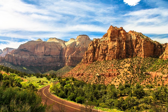
1. Canyon Overlook Trail


Photo by Alexander Edsjö
- Area: Zion Canyon
- Permit: No, you only need a park pass
- Difficulty: Easy to Moderate
- Distance: 1 mile
- Elevation: 163 feet
- Time Hiking: About 1 hour
- Best Time to Hike: Spring through to autumn
You can reach the viewpoint of lower Zion Canyon and Pine Creek Canyon by following the Canyon Overlook Trail.
The trail begins opposite the provided parking lot which is near the east entrance of the Mount Carmel Tunnel.
The hike is a shorter one, with the initial 40 or so steps probably being the steepest. After this you will ascend a stone ridge before working your way to the edge of an impressive cliff.
You will be able to see the expanse of the Zion Canyon before reaching the Outlook, luckily the drop offs are mostly fenced so you don’t have to feel nervous walking the cliff edge.
Accommodation: South Campground is closest but has no accessible facilities. Watchman Campground, slightly further away, but has access to restrooms.
Canyon Overlook Trail Tips
- Remember to wear proper trekking boots, as some parts of the trail are rocky and uneven.
- Get there early if you would like to find parking. The hike is very popular, so space fills up quickly, especially in peak season.
- Be aware that if you have balance issues or afraid of heights this may not be the hike for you.
- It’s a good idea to bring water along, especially in the hotter summer months.
2. Lower Emerald Pool Trail


Photo by Dale Haussner
- Area: Close to Zion Lodge
- Permit: No, you just have to have a park pass
- Difficulty: Easy
- Distance: 1,2 miles
- Elevation: 69 feet
- Hiking Time: 1 hour
- Best Time to Hike: Spring and fall are the most pleasant, as summer can be very hot
This is definitely a Zion classic that should be on your list of hikes to do in the park.
A paved path leads you to Lower Emerald pools, waterfalls and lush green plant life - getting to this point is relatively, easy even for the elderly or very young.
From the lower pools you can continue onwards to middle and upper emerald pools, and for a longer hike you can include the Kayenta Trail and the Grotto Trail. How long you hike for is purely up to your preference.
Accommodation: Zion Lodge is just opposite the beginning of the trail.
Lower Emerald Pool Trail Tips
- Gets crowded in the summer months, so plan accordingly.
- The waterflow at the pools is usually quiet light, unless during a rainstorm or spring runoff.
- Kayenta and Upper Emerald Pools Trails are currently closed due to rock fall.
- If you are planning on using the park shuttle there is a stop at the Zion Lodge and further up, at the Grotto.
3. Angels Landing Hike


Photo by Elliott Ng
- Area: The Grotto
- Permit: No
- Difficulty: Strenuous
- Distance: 5.4 miles
- Elevation: 1,488 feet
- Hiking Time: 4 hours
- Best Time to Hike: Spring and fall, summer can be unpleasantly hot
Angels landing hike starts at the Grotto trailhead and follows the West Rim trail. After hiking up two sets of switchbacks you will eventually reach the top of a ridge.
This is the final part of the hike where you will follow the narrow ridge. Here the route has long drop off, and you can look down on both sides at the canyon below.
If you have no climbing experience the hike can be rather intimidating, however, the final viewpoint makes it worth it.
It definitely is one of the most scenic lookouts in the park and is worth adding to your Zion hiking list.
Accommodation: Zion lodge is the closest accommodation, followed by South Campground.
Angels Landing Trail Tips
- The Grotto is the 6th stop for the Zion Park Shuttle.
- Due to the strenuous and exposed nature of this hike, it is not advisable to take small children or if you are not hiking fit.
- The hike is one of the most popular in the park, so it may be very busy with other people.
4. The Subway Hike


Photo by Cédric ANTOINE
- Area: Just off the Kolob Terrace Road
- Permit: Yes, permits can be obtained at any visitors centre
- Difficulty: Technical
- Distance: 9,5 miles
- Time Hiking: 7 to 9 hours
- Best Time to Hike: Late spring to fall
The Subway is semi-technical hike and if you opt to do this route you’ll definitely be getting your feet wet, so a pair of good waterproof socks is a good idea.
Beginning at Wildcat Canyon Trailhead, the hike entails waking, scrambling and climbing down from the left fork of north creek - so the majority of the way the stream is your trail.
Hiking the Subway “top down” is the traditional way to do the route but is far more technical. If you would prefer the easier version, you can hike the “bottom up” route which starts and ends at the Left Fork trailhead.
Some of the holes in the river are deep so you may have to swim. While not your standard, everyday sort of hike this is definitely something worth considering if you are looking for a little more adventure and have some experience canyoneering.
Hikers are encouraged to either go with an experienced hiker who knows the area or obtain detailed information on the area prior to going.
Accommodation: The Lava Point Campground is the closest.
The Subway Trail Tips
- Remember to take lots of water, if you don't want to carry it separately, there are a number of hiking hydration packs that could be helpful.
- This is a day use area only.
- The route requires rappelling skills as well as 60 feet of rope if you are doing the more technical “top down” route.
- If there are warnings of rain don’t do this route, as flash floods are a potential risk.
- Only 80 people a day are allocated permits.
5. Weeping Rock Trail


Photo by John Weiss
- Area: Weeping Rock
- Permit: No
- Difficulty: Easy
- Distance: 0.4 miles
- Elevation: 100 feet elevation gain
- Time Hiking: 30 mins
- Best Time to Hike: Spring and fall
The hike to Weeping Rock is an easy walk that the whole family can do, however, although short the hike is quite steep. The paved trail ends in an alcove with dripping springs, literally a weeping rock. You should consider taking some trekking poles with.
If you are looking to pass the Weeping Rock while on your way to more serious hiking, the trailhead is also the starting point for the Observation Point Trail and Hidden Canyon amongst others.
Accommodation: Closest accommodation is Zion Lodge, with closest camping in the park being South Campground
Weeping Rock Trail Tips
- You can easily take the park shuttle to the start, as it begins at the no 7 stop.
- The Weeping Rock parking lot has bathrooms.
- Be aware that during rainstorms a large waterfall forms at weeping rock.
Zion National Park Hikes FAQ
Ranked the third busiest park in the US, Zion drew 4.5 million visitors in 2017.
Known for its breath-taking 2,000 foot sandstone cliffs, its narrow, deep canyons and the Virgin River, there are endless possibilities for exploration of Zion’s diverse habitats.
Zion National Park Quick Facts
- In the 1800’s Elke had been hunted to extinction from the park, but in the early 1900’s they were imported back into the park from Yellowstone.
- You can spot the California condor in Zion, as the birds are curious and are attracted to human activity. Due to a successful breeding program the species was saved from extinction.
- Human activity in the Zion area goes as far back as 6 000 BC.
- Zion takes its name from a Hebrew word meaning ‘place of relaxation and peace’.
Do I need a permit to hike in Zion National Park?
Permits are required if you are planning on backpacking overnight, day hikes do not need a permit with a few exceptions. You can get permits on the day, or the day before your hike. Reservations can be made for canyoneering, camping and climbing trips, using the online reservation system.
How much are Zion NP entrance fees?
When you visit the park, you will be required to purchase a recreational use pass.
- Individual 7 days > $20
- Motorcycle 7 days > $30
- Private Vehicle 7 days > $35
- Zion annual pass > $50
When is the best time to hike Zion National Park?
Spring and autumn have the mildest weather and therefore it is be best to time hike in Zion NP. Peak season in the Summer is very busy, and it can be very difficult to find parking in the park if you don’t wake up early enough to beat the masses - the park is busiest from March to October.
Are Zion National Park hikes difficult?
There are a large variety of Zion hikes to choose from, from easy, moderate to strenuous. Some of the easiest hikes are handicap friendly, so how difficult your hikes are is all down to your personal preference. It is important to keep your hiking experience, fitness levels and current trail conditions in mind when choosing your next Zion adventure.
Is altitude sickness a risk in Zion NP?
Yes, due to the varying altitudes you can experience altitude sickness in Zion national park. The Zion/Bryce canyon ranges from around 3,000 feet to 9,000 feet, with the higher altitudes possibly triggering illness. Drinking water and taking it easy for a few days are best if you are worried about your health.
What is the topography like in Zion NP?
Zion is located on the edge of the Colorado Plateau and forms part of what is known as the Grand Staircase Escalante National Monument. The staircase is a series of sedimentary rock plateaus that extends from Bryce Canyon, ending at the Grand Canyon.
Zion falls between the two, with the bottom layer of Zion forming the top of the Grand Canyon, and the top forming the bottom of Bryce Canyon.
Most of the rocks and formations in the park are sedimentary, meaning they are made up of older rocks or other organic matter which has been eroded and deposited in layers.
It is interesting to note that roughly 275 million years ago, Zion was a flat basin near sea level, however the uplifting, tilting and erosion of rock caused the formation of the place we see today.
The deep canyons and sheer cliffs mean the park has an elevation change of roughly 5,000 feet, which means that altitude sickness is something you have to be mindful of.
What wildlife and plants might I see on a Zion NP hike?
The park is home to a variety of habitats and species due to the diverse levels of elevations and water. Water, or lack thereof, is a large influencing factor in what grows and lives where.
The park is home to over 291 species of bird and over 78 species of mammals and creatures you can expect to see include mule deer, wild turkeys, canyon tree frogs and grey foxes. Nocturnal animals include mountain lion and porcupines.
With roughly 1,000 species of plant, you can expect to see anything from lush hanging gardens in the canyons, to arid grasslands on the lower plains, to mixed aspen and conifer forests on the high plateaus.
What hiking map do you recommend for Zion NP?
Zion National Park is located in southern Utah, near the city of Springdale.
Free maps and information are easily accessible online, but if you would like to prep your route beforehand and have a hard copy on hand while you hike we recommend National Geographic’s Illustrated topographic map of Zion.
The map is waterproof and tear-resistant, so it should stand up to some roughing it along the way.
The park is open all year and has two visitors centres which guests are encouraged to explore - the Zion Canyon Visitor Centre and the Kolob Canyon Visitor Centre.
The park also has a museum which exhibits the history of the park.
What guidebook do you recommend?
For a fantastic guidebook on Zion and the Bryce Canyon we recommend Lonely Planet Zion & Bryce Canyon National Parks (Travel Guide). Giving you insider tips, budget honest reviews and full color trail and park maps, you can’t go wrong with this researched and updated guide.

Browse more US National Park hikes
See our picks for the Best Hikes in America, or check out these popular hikes.
