Looking for the best hikes in Yosemite National Park? You're in the right place. We have curated the top Yosemite hikes that you simply cannot miss.
These hikes showcase landmarks that make Yosemite famous around the world: from towering waterfalls like Yosemite, Bridalveil, Nevada, and Vernal to stunning granite rock formations like El Capitan and Half Dome. Yosemite is bound to exceed your expectations.
Best Hikes in Yosemite
Yosemite is a hiker’s paradise. With 800 miles of trails all varying in difficulty, Yosemite has amazing adventures on offer.
Most trails can be customized to your hiking experience by shortening the trip or taking alternative routes. Anything from easy walks in the valley, to strenuous hikes up to the Half Dome, Yosemite caters to exactly what you are looking for.
You can choose to do small sections of the park, but a long 7-8 day hiking trip can cover pretty much all the major points of interest.
As far as I can tell, best hikes in Yosemite are:
- Half Dome hike
- Four Mile hike
- Yosemite Falls hike
- Panorama trail hike
- Pohono trail hike
1. Half Dome Trail

- Area: Yosemite Valley
- Permit: Yes
- Difficulty: Moderate-Difficult
- Distance: 14.2 miles round-trip
- Elevation Gain: 4,800ft
- Days/Hours: 1 day, 10-12 hours
- Best Time to Hike: May-October. May through October when climbing cables are in place. Although, if you are looking to see waterfalls at their best, consider visiting earlier in the year.
Route Description
You can reach the scenic Half Dome through the Mist Trail. This is via Yosemite’s most famous rock face. While on the Mist trail, you’ll come across two waterfalls, the Vernal Falls and Nevada Falls. You will continue through little Yosemite Valley until you reach the sub dome. You will then use the cables to go up the steep 400ft portion of the hike.
If you are uncomfortable with heights and some mountaineering skills, this portion to reach the top will be challenging. In fact, this section up steep rock makes this trail a candidate for the scariest hike in the world.
This hike is versatile, as you do not need to go all the way to the top, making it suitable for all levels, although it is not recommended for families. Keep in mind that this trail can get very crowded so the park requires you to purchase a permit beforehand to prevent this.
Accommodation
The Majestic Yosemite Hotel, Half Dome Village, Yosemite Valley Lodge, Little Yosemite Valley Campground
Half Dome Trail Top Tips
- Take Yosemite’s public transit bus (YARTS) to avoid busy parking lots and traffic.
- Check the weather before beginning your journey. When using the cables, bad weather can make you climb extremely dangerous.
- Book your permits with Yosemite National Park ahead of time.
- Pack a rain jacket and put electronics away, the falls make the trail misty and wet. This calls for hiking boots with excellent traction as well.
- The views at the top of Half Dome are spectacular and you will want to stick around so pack a picnic.
2. Four Mile Trail

- Area: Glacier Point
- Difficulty: Difficult
- Distance: 9.6 miles round trip
- Elevation Gain: 3,200ft
- Days/Hours: 1 day, 6-8 hours
- Best Time to Go: Spring and summer, waterfalls levels are at their prime
Route Description
Begin your journey up the Four Mile Trail at Sentinel Rock and reach the finish line at Glacier Point Visitor Center. After 1 mile, you’ll already be stunned with picturesque views of Yosemite Falls, Sentinel Dome, El Capitan, and Half Dome.
During the summer you’ll be able to treat yourself to a tasty reward at the snack stand at the end. This hike could be altered to be shorter or longer depending on your preference.
You could either stop at Glacier Point or continue your journey onto the Panorama Trail and then the Happy Isles Trailhead, adding an additional 8.5 miles to your hike.
Accommodation
The Majestic Yosemite Hotel, Yosemite Valley Lodge, Little Yosemite Valley Campground
Yosemite Mile Hike Tips
- Begin your hike early, it can become very hot mid-day. This means you will also need plenty of water, 2-4 quarts depending if you take the shorter or longer route. There is no drinking water available unless the Glacier Point Snack stand is open (late May to Mid October).
- Utilize the El Capitan or Valley Visitor Shuttle to get to Four Mile. If you are only hiking to Glacier Point, make sure your transportation is booked ahead of time. There is no free shuttle from Glacier Point to Yosemite Valley.
- Pets, bicycles, and strollers are prohibited.
- This trail is only partially paved: ensure you are wearing proper hiking shoes as sprained ankles are common.
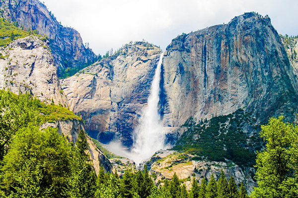
3. Yosemite Falls Trail

- Area: Yosemite Valley
- Difficulty: Difficult
- Distance: 2 miles Columbia Rock, 7.2 miles Yosemite Falls
- Elevation Gain: 1,000 Columbia Rock, 2,700 Yosemite Falls
- Days/Hours: 1 Day
- Best Time to Go: Spring and summer
Route Description
One of the oldest historic trails leading to North America’s tallest waterfall, Yosemite Falls. The trail to Columbia Rock begins along the Valley Loop Trail, with an immediate climb. Once you are above the trees, you will experience stunning views of the valley.
It is completely worth hiking an additional 0.5 miles to get a view of Yosemite Falls but it is also worth hiking to the top to be right next to Yosemite Falls.
The falls are majestic and you will be in awe of the size, considering a small creek is feeding it. From the top of the falls, you could extend your hike to Yosemite Point (adds 1.6 miles) or Eagle Peak (adds 5.8 miles).
Accommodation
Yosemite Lodge at the Falls, Yosemite Valley Lodge, The Majestic Yosemite Hotel, Upper Pines Campground
Yosemite Falls Hike Tips
- Take care of yourself and know your limits. Begin your hike early to beat the heat and drink plenty of water.
- Wear sturdy hiking boots and stay on the trail.
- Do not swim in the creek and proceed with caution near the creek. This leads directly into a waterfall and can be dangerous
- There are two shuttles available, the Valley Visitor and El Capitan Shuttle.
4. Panorama Trail

- Area: Glacier Point
- Difficulty: Difficult
- Distance: 8.5 miles one way, 17 miles round trip
- Elevation Gain: 3,200ft
- Days/Hours: 1 day, 7-9 hours
- Award: Best Overall Hike
- Best Time to Go: Fantastic year round, but the waterfalls are best in spring and summer.
Route Description
This hike offers the best of Yosemite. It combines two of Yosemite’s most iconic hikes, Glacier Point and Mist trail. Your journey will begin along the Mist Trail to the Vernal and Nevada Falls. From here, you will follow the John Muir Trail to the Panorama Trail.
You will see stunning views of the Half Dome. While crossing Illilouette Falls and several switchbacks, you will be presented with wonderful views of Yosemite Falls. 8.5 miles later, you will reach Glacier Point.
Accommodation
The Majestic Yosemite Hotel, Yosemite Valley Lodge, North Pines Campground
Yosemite Panorama Trail Hike Tips
- Take the shuttle to avoid the additional 3-mile walk to your car.
- Most of this hike is downhill but Mist Trail can be harsh on the knees. If you are looking to avoid this, take the Muir trail instead.
- Don’t miss the short trail (1 meter) to Panorama Point. It is unmarked and often skipped but has the most amazing views of Glacier Point, the Royal Arches, and North Dome.
- If you stay at the Yosemite Lodge, there is a bus that will take you to the trailhead.
5. Pohono Trail

- Area: Glacier Point
- Difficulty: Difficult
- Distance: 13.8 miles
- Elevation Gain: about 3,400ft
- Days/Hours: 1 day, 5-10 hours
- Best Time to Go: Spring or Summer, but be cautious for snowfall.
Route Description
The Pohono trail is most often used as a downhill trail from Glacier Point. It is an easy to west trail along Yosemite’s south rim. It is a less popular trail, which means you get to be one with nature, an uncommon occurrence while visiting Yosemite. It offers several brilliant viewpoints.
These include Taft Point, Dewey Point, Crocker Point, and Stanford Point. You can’t forget about the incredible falls found on most Yosemite hikes, Vernal, Nevada, Yosemite and Bridalveil. You will see all of this and more while on the Pohono trail.
Accommodation
Yosemite Valley Lodge, The Majestic Yosemite Hotel, Yosemite High Sierra Bed &Breakfast, Upper Pines Campground, Tamarack Flat Campground
Pohono Trail Pro Tips
- This is a strenuous hike and does include climbing. You need sufficient experience, proper hiking boots, and hydration to complete this adventurer.
- If you aren’t comfortable with a gruelling hike, avoid the Tunnel View to Glacier Point route. Take the reverse direction instead.
- When staying at Yosemite Lodge, take the shuttle to the trailhead. This eliminates the added stress of parking.
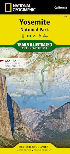
Yosemite Hikes Map
Yosemite National Park is located in California, United States. It is situated East of San Francisco and Sacramento and North of Los Angeles. Yosemite is made up of the Sierra Nevada Mountains and its land area is 1,200 square miles.
There is always free maps and information available at the Yosemite Valley Visitor Center and Valley Wilderness Center, but if you need to prep your route in advance, there is a National Geographic Yosemite detailed map
There are 5 different entrances and it is divided into 5 areas:
- Yosemite Valley
- Wawona/Mariposa Grove/Glacier Point
- Tuolumne Meadows
- Hetch Hetchy
- Crane Flat/White Wolf
Yosemite Guidebook
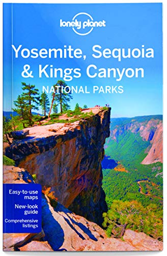
For an awesome book of general things to do in Yosemite, hiking tails, backpacking trails and more, we recommend The Complete Guidebook to Yosemite National Park by Steven P. Medley.
There is also an amazing visually-driven The Photographer's Guide to Yosemite that is worth getting to see if you could find and replicate the stunning beauty of the park.
And of course, the most reader-friendly guide that provides information in bite-sizes is from Lonely Planet Yosemite, Sequoia & Kings Canyon National Parks (Travel Guide).
Yosemite National Park
Yosemite National Park is a World Heritage Site and attracts over 4 million visitors every year.
Most visitors spend a majority of their time in Yosemite Valley, which leads to the Tunnel View entrance.
This is the beginning of most hiking trails that lead to higher elevations and stellar views.
Topography
Four million years ago, the Sierra Nevada Mountains were uplifted becoming the range it is today. Yosemite is now filled with mountains made of granite rock and steep cliffs. This leaves a wide range of elevations and climates.
El Capitan is an example of a dramatic rock formation located on the North side of the valley. The highest point reaches 7,573ft, making the face of El Capitan an epic playground for rock climbers and base jumpers.
For those who prefer a less daunting experience, El Capitan can be hiked by taking the Yosemite Falls route and heading west.
Wildlife and Plants
With the diverse levels of elevations and climates, Yosemite is home to over 7,000 plant species and 400 animal species.
The area is known for hundreds of species, but it wouldn’t be as special without its giant sequoias and black bears.
For the protection of plants and animals, the park is 95% designated wilderness, which prevents visitors from entering certain areas in the park.
Yosemite Quick Facts
- 95% wilderness
- 800 miles (1,300 km) of hiking trails
- Approx. the size of Rhode Island
- 4 million visitors per year
- Climate: Mediterranean. Featured in the beginning of Start Trek V
- Yosemite means ‘killer’ in Miwok (Native American language)
- El Capitan is one of the world’s most popular rock climbing mountains
- Please note: If you plan on staying in the park overnight, you will need a Wilderness Permit and this will require you to use bear-resistant food storage.
Frequently Asked Questions
Do I need a reservation to go on Yosemite hikes?
How much are Yosemite entrance fees?
When is the best time to visit Yosemite?
Is altitude sickness a risk?
Are Yosemite hikes difficult?
What gear do I need?

Browse more US National Park hikes
See our picks for the Best Hikes in America, or check out these popular hikes.
