The Four Mile Trail is another iconic hike with all of the best views of Yosemite.
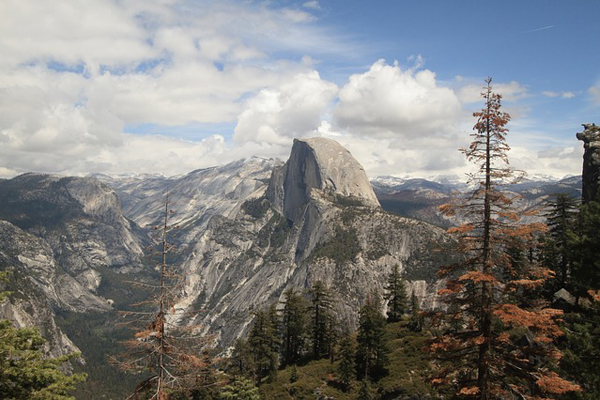
This includes panoramic views of the valley, Yosemite Falls, Cathedral Rocks, El Capitan, Sentinel Rock, Half Dome, North Dome, Clouds Rest, and the Royal Arches.
Here is our complete guide to the Four Mile trail.
Four Mile Trail
Route Overview
The Four Mile Trail is one of the leading day hikes out of Yosemite Valley.
This trail was once only 4 miles long one-way in the 1970’s, now it is closer to 5. It can be conveniently shortened as a one way or combined with the Panorama Trail.
The trail offers 9.6 miles of brilliant views of some of the most famous landmarks in Yosemite. You will likely take the full 8 hours if you stop and soak in all the sights. This hike is strenuous and does include steep climbs and several switchbacks.
Best Time to Hike the Four Mile Trail
This trail can be hiked any time of year except when it is closed in the winter. The trail opens in May but a portion of the trail may remain closed due to snow accumulation.
To see the falls at it’s fullest, visit in springtime. It is best to begin this hike early in the morning on a clear day so you can get the complete clear view of the Cathedral Rocks and El Capitan.
Best Views on the Four Mile Trail
You will get the best view of Yosemite Falls during the spring and summer. If it’s a hazy or cloudy day, you may want to postpone this hike until the weather clears, this will ensure you get to see everything the Four Mile has to offer.
Top Tips
The Four Mile Trail can become very hot mid-day and can also tend to get hazy, obstructing some of the most famous views. Begin your hike early. It is crucial to not be tempted to cut switchbacks. This is illegal in Yosemite National Park and could put you in life-threatening danger.
It is also important to wear proper hiking boots, that way you can avoid ankle injuries. These are common along the Four Mile Trail. Pets, bicycles, and strollers are also not allowed on this trail.
Do I need a permit?
Permits are not required, if you don't intend to stay in the park.
However, anyone who hikes the Four Mile Trail and stays overnight needs to obtain a Wilderness Permit beforehand. These are free.
To increase your chances of obtaining a permit, apply for less popular days such as Sundays-Thursdays in September and October.
Or come to get a permit after 11am on the day before your hike. 40% of permits could be available then.
See more information on the National Park Service website.
How difficult is the hike?
There are difficult and easy parts along this trail.
The best part about the Four Mile is that it is wide and smooth and less steep than some other trails out of the valley.
It can be customized depending on your own preferences. This is one of the few hikes in Yosemite National Park that you can be completed as a one-way.
Top to Bottom vs Bottom to Top
Most hikers choose to take the top-to-bottom route. This is the shorter 4.8-mile, one-way hike that begins at Glacier Point and ends at Yosemite Valley.
For a more scenic option, hiking from bottom-to-top (Yosemite Valley to Glacier Point) is best. The more scenic option is obviously longer and harder, but it is well worth to see the views gradually during your ascent.
When hiking bottom-to-top, you will begin your climb out the valley at the Four Mile Trailhead near the swinging bridge. Once you have reached heights above the trees, the views will have you in awe.
One mile later, you will be faced with a full view of Yosemite Falls. Seeing Yosemite Falls in its entirety is nearly impossible anywhere else in the park besides on the Four Mile Trail. At this moment, you will also experience a reverse tunnel view of Cathedral Rocks and El Capitan.
Sunrise Hike
For an epic sunrise, hike up early in the morning and see the dramatic peaks illuminated by an orange glow. After 3 miles from the bottom, you will pass through a trail gate.
Here onwards, expect to see Yosemite’s most famous sites, Tenaya Canyon, Half Dome, North Dome, and the Royal Arches. From here, you can either stop at Glacier Point or continue back down using the Four Mile Trail or Panorama Trail.
If you are hiking one way, you will want to arrange mode of transport or pay for a shuttle back to the valley.
Getting There and Back
There are several ways to get to the Four Mile trailhead. You could either use the El Capitan Shuttle (May to October) or the Valley Visitor Shuttle (year-round). If you are looking to hike the Four Mile Trailhead one way, you will want to arrange transport ahead of time.
There is no complimentary shuttle between Glacier Point and Yosemite Valley. You can purchase a bus ticket at Yosemite Valley Lodge Tour and Activity desk at least 30 minutes before departure. This bus service also runs daily-guided tours at various locations like Glacier Point and Yosemite Valley.
Four Mile Trail Map & Guidebook
The Four Mile Trailhead is found in Yosemite Valley along the Southside drive in. The trail ends in Glacier Point.
For a detailed guide to Yosemite National Park that includes maps and information about Yosemite Falls Trail check out Yosemite: The Complete Guide: Yosemite National Park by James Kaiser.
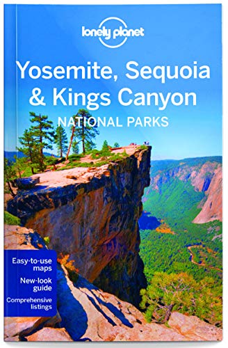
For an overview of Yosemite National Park, Yosemite, Sequoia & Kings Canyon National Parks by The Lonely planet is an excellent read. It features maps, itineraries, insider tips, and reviews for what to eat and where to sleep within Yosemite.
Four Mile Trail Itinerary

This is a strenuous hike, so it is not as commonly filled with tourists. Make sure to bring plenty of mosquito repellent, drink plenty of water, and bring snacks. This will be a workout you will want to be prepared for.
Yosemite Valley to Yosemite Falls
Union Point to Glacier Point
Finish or Keep Going
Four Mile Trail FAQ
What gear do I need?
Hiking the Four Mile Trail requires a few pieces of essential gear. The trails near the waterfalls can be slippery. This calls for hiking boots with excellent traction. Trekking poles are also a great idea. In case your journey back goes past dusk, a headlamp is a must.
When hiking in hot temperatures, you must wear sunscreen and a hat. Bring plenty of food and snacks as well as drinking water to stay hydrated.
Is altitude sickness a risk?
It is unlikely. The total elevation gain along the Four Mile Trail is 3,200ft. Anything over 5,000ft puts you at risk for altitude sickness. However, it is important to have a solid understanding of the risks associated with high altitude hiking and how the body acclimatizes to high altitude..
We recommend you read our detailed article on Altitude Sickness and Acclimatisation. It is crucial to drink plenty of water, eat along the way, and take frequent breaks in the shade.
Which way is the best way for scenic views?
Beginning the Four Mile Trail from the Valley floor and ending at Glacier Point is the best for views. Once you are high enough to see above the trees, the views are much more dramatic and breathtaking than beginning from the top.
Are there restrooms or place to get water/snacks along the trail?
No. Restrooms are found in Yosemite Valley (east of the Swinging Bridge Picnic Area) and in Glacier Point near the parking lot. The Glacier Point Snack Stand is open May to October, you can purchase water and snacks here. You should bring at least 2 quarts/liters of water to hike the Four Mile Trail one-way. Bring 4 quarts/liters for the round-trip option.
What travel insurance do I need?
Hiking insurance is important when going on the Four Mile Trail. If an accident or incident should occur that requires immediate medical assistance and evacuation you will most definitely want adequate hiking insurance that can cover the costs of air ambulance and treatment.
Where can I park if I don’t want to use the shuttle service?
There is parking available at Southside Drive in Yosemite Valley or at Glacier Point where the trail ends. When doing this hike one way, it is easiest to take a shuttle or arrange for someone in your party to pick you up.
Is there an easy route?
For an easier hike but less scenic, take the Four Mile Trail from Glacier Point to Yosemite Valley. For a harder hike with more rewarding views, hike the Four Mile Trail from Yosemite Valley to Glacier Point. To make it easier overall, hike this one-way. For a tougher alternative, hike it round trip or use the Panorama Trail making this adventure 14 miles long.

Browse more US National Park hikes
See our picks for the Best Hikes in America, or check out these popular hikes.
