Looking for a 13-mile hike showcasing Yosemite’s most famous landmarks? This guide will provide you with all the information necessary to hike the Pohono Trail.
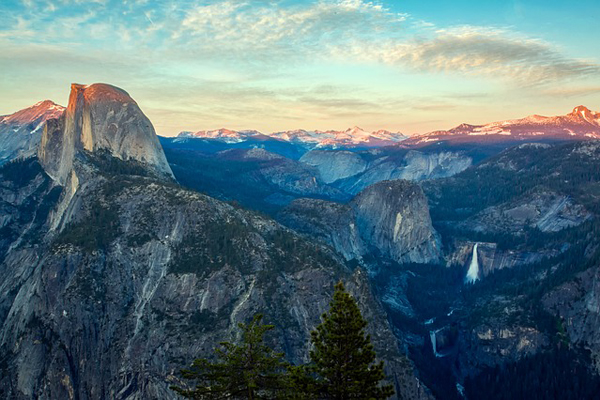
Expect to see all the falls: Vernal, Nevada, Yosemite, Bridalveil, and Half Dome, Sentinel and Cathedral Rocks, and El Capitan.
Pohono Trail Hike in Yosemite
Route Overview
The Pohono Trail is a fantastic east-west hike guiding you along Yosemite Valley’s south rim. It is most commonly hiked from Glacier Point to Tunnel View and less commonly vice versa.
This trail hits several lookout points including Glacier, Taft, Dewey, Crocker, Stanford, and Inspiration. These points are a must to stop by and soak in the panoramic views.
It is 13 miles one way and can take anywhere between 5-10 hours to complete. The Pohono Trail is rated at high difficulty due to a few points of strenuous climbs.
Best Time to Hike Pohono Trail
The Pohono Trail is best to hike from mid-May to early November. This is when Glacier Point Road is open.
If the waterfalls are what you after, consider visiting closer to the months of May, June, or July.
During the summertime, expect larger crowds at the beginning and end of the trail.
During the hike, some hikers are likely to meet you at the Sentinel Dome or Taft Point. During this time of year, you will want to bring along some mosquito repellent and leave early to avoid full parking lots.
Pohono Trail Route
The route can be customized completely depending on your abilities and whether you are still recovering from other hikes, like the Half Dome trail.
The easier path goes from Glacier Point to Tunnel View, whereas the more challenging option, goes from Tunnel View to Glacier Point. Glacier Point is found along the south wall of Yosemite Valley, a 32-mile drive along Highway 41. Tunnel View is found whilst driving along the same highway towards Wawona.
When beginning at Glacier Point, you have two options, either to go past the base of Sentinel Dome or go directly up it. The views are absolutely breathtaking from the top of the dome but this will add 300 vertical feet to your hike.
From here, you will continue on to Taft Point, Bridalveil Creek Crossing, Dewey Point, Crocker Point, Stanford Point, and Inspiration Point. All these points offer stunning views of the valley, falls, El Capitan, and Half Dome.
Once you hit Inspiration Point, you are a short mile and half away from your finish line at Tunnel View.
Please Note: Pick the right route for you. If you are looking for an easier alternative, begin your hike at Glacier Point. If you are looking for a challenge, begin at Tunnel View. Also, only climb the Sentinel Dome if you feeling up to it. It is an additional 300ft equaling a total of 3,700ft of elevation gain.
The mile and a half between Inspiration Point and Tunnel View is rigid and rocky. Watch your step and don’t rush.
Route Extensions
You can make this one-way a round trip, totaling to a 26-mile hike. Hike up the 4-mile trail to get to Glacier Point, an additional 4.8 miles.
Or detour south onto the Dewey Point Trail to see McGurk Meadow adding 1 mile. Lastly, climb 300ft to the top of Sentinel Dome for breath-taking views.
Permits to Hike the Pohono Trail
This hike is a one way, making it crucial to have a plan to get back home. If you are extremely fit and can handle the 26 miles round trip in one day, you would only need to park your car at one lot and return where you left it.
Most people will only do the Pohono Trail one way and have two people park in their party in both lots. That way if you start at Glacier, you can finish at Tunnel view and get a ride back to the other lot. This is the most reliable option.
If you are interested in a shuttle, Glacier Point tour bus leaves Yosemite Lodge, several times a day. There are free buses available that transport hikers from Tunnel View to Glacier Point and vice versa.
These buses aren’t reliable, as tickets cannot be reserved and there are no set times they arrive and depart.
Pohono Trail Quick Facts
- Elevation: With Sentinel Dome: 3,700ft (1,130 meters). Without Sentinel Dome: 3,400ft (1,030 meters)
- Difficulty: Strenuous
- 13 miles or 21km one-way, 5-10 hours
- East to West: Glacier Point to Tunnel View
Recommended Guidebook
For a detailed guide to Yosemite National Park that includes maps and information about Pohono Trail check out Yosemite: The Complete Guide: Yosemite National Park by James Kaiser.
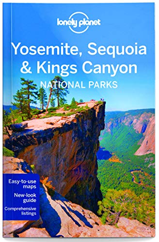
For an overview of Yosemite National Park, Yosemite, Sequoia & Kings Canyon National Parks by The Lonely planet is an excellent read. It features maps, itineraries, insider tips, and reviews for what to eat and where to sleep within Yosemite.
Pohono Trail Itinerary

- Hike to Sentinel Dome: Begin your hike at Glacier Point.
- Trek to Taft Point: Once you have reached Taft Point, continue until you reach Bridalveil Creek Crossing (2 miles)
- Hike to the Lookout points: After the creek crossing, you will reach several lookout points. These are Dewey, Crocker, and Stanford.
- Downhill hike: Hike downhill for a view of Upper Yosemite Falls (0.5 miles)
- To the finish line: Reach the final lookout point, Inspiration Point and proceed until you meet with Tunnel View.
Pohono Trail FAQs
Should I climb Sentinel Dome?
If you want to appreciate everything Yosemite has to offer, Sentinel Dome is the most epic and accessible 360-degree view in all of Yosemite. It only adds .25 of a mile to your hike with an additional 300ft vertical gain. It is completely worth it if you have the energy and are open to a relatively easy climb.
What Pohono Trail route should I take?
If you are an experienced hiker and up for a challenge, begin the Pohono Trail at the Tunnel View trailhead. If you are looking for an easier route to save your strength for the Half Dome, begin at Glacier Point.
What's the best way to get to and from Pohono trail? Car, shuttle or bus?
The most reliable modes of transport are by car or via the Glacier Point Tour Bus. If you are able to, have both members of your car park at Tunnel View and Glacier Point. If a car isn’t an option, purchase a ticket to take the Glacier Point Tour Bus. They depart daily from Yosemite Lodge at 8:30 am, 10 am, and 1:30 pm. One-way tickets for adults are $25 while round-trip is $41. Although slightly pricey, it is better to know you have a seat reserved and a way to get back.
Is altitude sickness a risk on Pohono trail?
It is unlikely. The total elevation gain along the Pohono Trail is 3,700ft including Sentinel Dome. Anything over 5,000ft puts you at risk for altitude sickness. However, it is important to have a solid understanding of the risks associated with high altitude hiking and how the body acclimatizes to high altitude. We recommend you read our detailed article on Altitude Sickness and Acclimatization.
We recommend you read our detailed article on Altitude Sickness and Acclimatization. It is crucial to drink plenty of water, eat along the way, and take frequent breaks in the shade.
What gear do I need for Pohono trail?
Hiking the Pohono Trail in Yosemite requires a few pieces of essential gear. Trekking Poles are a must, especially in rocky areas of the trail, especially in the mile between Inspiration Point and Tunnel View. The path here is rigid and uneven.
When hiking in Yosemite in the summer, temperatures are high and hat and sunscreen are a must. There will be creeks you will cross along this trail, hiking boots with excellent traction and mosquito repellent will help a ton.

Browse more US National Park hikes
See our picks for the Best Hikes in America, or check out these popular hikes.
