Himachal is an Indian section of the Himalayas that definitely should not be missed.
To help you choose which of Himachal treks would be best for you, we have information on our top 5 – from easier 1-2-day hikes, to strenuous treks that cover 62.1 miles. There is a Himachal trek for everyone.
See India's overall best hikes for a complete list of hiking trails.
Best Hikes In Himachal
Indrahar Pass Trek
- Area: Dhauladhar, Himachal Pradesh
- Permit: You can choose to do this hike as organised by a tour group
- Difficulty: Moderate
- Distance: 27.3 miles
- Elevation Gain: 14 517ft
- Days/Hours: 1 day, 10-12 hours
- Best Time to Hike: May-October

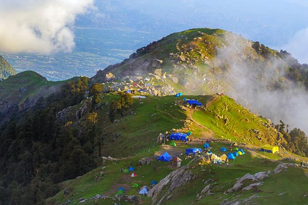
Photo by Himalayan Explorers
Indrahar is a pass in the Dhauladhar mountain range of Himalayas. The pass is at an altitude of 14 517ft above sea level, close to the town of Dharamshala.
The hike is a spectacular trek through awe-inspiring Himalayan ranges, and you will be exposed to beautiful lakes, gorges and forest along the way.
The trek is considered to be one of the easier to moderate hikes in Himachal Pradesh. Beginning in McLeodganj, the trek makes its way to Triund, and this first bit is generally relatively easy.
From here you will journey to Lahesh Cave via Laka Got. The natural rock shelter that is Lahesh Cave is definitely a highlight of the trip.
The following day, you will hike up the Indrahar pass. This is probably the most technical part of the hike, with roughly 400m steep (1 312ft) climbing. However, the incredible view of the Pir Panjal Range makes it worthwhile.
Accommodation: The night prior and post the trek can be spent in hotels in McLeodganj and Chamba. During the trek you will stay in tents.
Top Trek Tips
- You can hike with or without a guide, the choice is yours and comes down to your preference.
- Although the water from glacial streams is clean, it is always advisable to boil water for purification purposes.
- The last place to get food and water (with certainty) is Triund, so keep this in mind when planning your hike.
- The pass may be covered in snow, and in this case trekking poles may be a good idea.
Triund Trek
- Area: Dhauladhar, Himachal Pradesh
- Permit: No
- Difficulty: Easy
- Distance: 5.6 miles
- Elevation Gain: 9 350ft
- Days/Hours: 5 - 6 hours
- Best Time to Go: March to June. However, the trek is accessible throughout the year with the acceptation of January and February, when heavy snowfall may cut off some sections.

This is probably one of the easiest Himachal treks, being under 5.6 miles and taking roughly 5 hours. However, this doesn’t make the route any less spectacular, and it is known for being one of the most scenic.
Beginning in Dharamkot or McLeod Ganj, the hike offers amazing views of the Dhauladhar ranges and the Kangra valley, and throughout the day, from sunrise, sunset and even moonrise, amazing panoramic views are offered.
Although a short hike, there will be several steep climbs along the way, however the first 3.1 miles are easy, and it is only hereafter that the steepness increases. The final km is nicknamed “22 curves” as it consists of 22 curves enroute before reaching Triund.
Another exciting aspect of the undulating path is that it passes through forests of rhododendron and oak trees. The trek finishes in Bhagsu Village. As it is short and well-marked it is not necessary to use a guide for this trek.
Accommodation: You can choose to stay in a hotel or pitch camp at McLeod Ganj. You can choose to do the hike in a single day or overnight in Triund, where you can either camp or stay in the guest house if you don’t want to.
Top Trek Tips
- Pack light, as this is one of the easiest and shortest hikes you won’t need much more than a rain jacket, phone, snacks and water in a small day pack. (if you are doing it in a day).
- If you want to buy snacks buy them in McLeod Ganj as they are cheaper here.
- Remember to wear proper hiking shoes, you will be especially grateful on the descent.
Pin Parvati Trek
- Area: Himachal Pradesh
- Permit: Necessary forest and camping permits may be involved, so it is a good idea to check with the organisers before embarking
- Difficulty: Difficult
- Distance: 62.1 miles
- Elevation Gain: 17 450ft
- Days/Hours: 11 Days
- Best Time to Go: July to September

Photo by lakshit seth
One of the more challenging Himachal hikes, the Pin Parvati trek requires excellent trekking skills and technique. The trek should only be attempted by experienced hikers as there are a few sections of the hike that are very dangerous, such as the narrow trail with hardly any foot holds that runs over the Parvati river.
In case of emergency, evacuation is also very difficult as the trails are too narrow to carry a stretcher, this is particularly worrying if someone suffers from AMS and needs medical attention quickly.
Beginning in Barsheni village in the Kullu valley, the trek connects the Parvato Valley (Kullu side) with the Pin Valley (Spiti side). The treks rugged mountains and high altitudes makes for a tricky climb.
When attempting the Pin Parvati Pass itself (around day 6), you will hike from Pin Parvati base camp to up the pass and back down to the base camp.
The pass is tough because of the altitude; however, the view of both the Pin Valley and Parvati Valley makes the climb worth it.
Accommodation: You will camp most nights on the trek.
Top Trek Tips
- The trail should not be attempted by those who are new trekking, prior experience at high altitude is essential.
- It is advisable not to do the hike too quickly. The harsh terrain, long distance and altitude gains make altitude sickness and fatigue problems common.
- It is recommended to include at least two buffer days in your itinerary, which can be used as acclimatization or rest days. Sometimes poor weather may delay you, and it’s also for this reason that buffer days are a good idea.
- Weather can change very quickly, and rain can make the rivers swell to the point of washing away the bridges crossing them.
Beas Kund Trek
- Area: Near Manali
- Permit: Organised treks will include trekking permits and forest camping charges
- Difficulty: Moderate
- Distance: 29.2 miles
- Elevation Gain: 12 139ft
- Days/Hours: 3 - 4 days
- Best Time to Go: May - June, September - November

Photo by trek trails
Beas Kund is a high altitude, alpine lake and the trail there begins in Solang Valley, which is known for skiing and paragliding. When passing into the Solang valley the trail enters a pine forest surrounded by mountains.
The trail goes via Dhundi and Bakarthach, and from Bakarthach you can trek to Beas Kund and back.
The beautiful lake is the origin of the River Beas as well as the base camp for numerous summit peaks. After returning to Bakarthach you begin making your way back, ending in the Solang valley again.
Accommodation: All night enroute will be spent in tents.
Top Trek Tips
- It is advisable to carry all your water as there is guaranteed water supply.
- If you have access to clean, fresh water along the way it is advisable to fill up your containers.
- Wear good hiking boots with ankle support as you will need grip on the rocky hillside.
- The trek is suitable for both experts and novices alike.
Hampta Pass Trek
- Area: Near Manali
- Permit: Organisers will include trekking permits in their packages
- Difficulty: Moderate
- Distance: 16.2 miles
- Elevation Gain: 14,035 ft
- Days/Hours: 5 - 6 days
- Best Time to Go: May - June, August - September

Easier than the Himachal trek, the Hampta pass is an unusual pass that allows hikers to cross between Kullu valley and Lahual valley. The trek climbs from the lush Kullu valley, up to an overhang on the mountains.
From this overhang, one can see the barren Lahual valley, which is a contrast to the green Jawa meadows in the Kullu valley.
The variation of scenery on this trail is pretty epic and is one of the routes biggest attractions. From green grassy meadows, serene forests and barren valleys.
On the day that you cross the Hampton pass you will come across glaciers, and if you are hiking in early summer the area by Deo Tibba peak may be covered in snow.
The decent is slightly more difficult that the climb up, and you will follow a zigzag path until you reach the valley below.
Ending at Chandra tal, the hike is classified as moderately difficult and therefore won’t be one that will put too much strain on your body, however you will have to be aware of altitude sickness, as the trek is at such high elevation levels.
Accommodation: You will stay in tents on the duration of the hike.
Top Trek Tips
- AMS is a risk, so it is important to always stay hydrated and be aware of your body to catch any symptoms early.
- Proper hiking shoes with ankle support are a key item of gear, especially with the day that summits the Hampton pass.
- Trekking poles are also a good idea, as they will make hiking through snow easier.

Himachal Treks FAQ
Do I need a permit to go on Himachal hikes?
Most places in Himachal do not require a permit. However, if you are visiting the Spiti Valley region, you will be required to have a Protected Area Permit (PAP).
You can also choose to book a hiking tour; in which case, you will have to make prior arrangements.
When is the best time to visit the Himachal area?
Summer (March to June) is the best time to visit the Himachal area. October is also a good month as this is when the snow is melted. July to September is considered monsoon season and November to February is winter. However, the area is sure to inspire and delight you regardless of when you visit.

Is altitude sickness a risk on Himachal treks?
Yes, altitude sickness is a risk on Himachal treks as it commonly occurs above 2,400 m. You will have to be careful and ensure that you do not ascend any climb too quickly, as rate of ascent and physical activity at altitude can cause AMS (acute mountain sickness). Staying hydrated, giving your body time to acclimatise and ensuring that you are physically fit can help avoid the onset of AMS.
Are the Himachal hikes difficult?
Generally speaking, yes, Himachal hikes range from moderate to difficult. While this does not mean that they aren’t a variety of hikes to choose from, many of the said hikes span over several days and higher altitudes. Therefore, it is important that you are adequately fit and prepared.
What gear do I need for a trek in Himachal?
This depends on where and how long you will be hiking for. Good hiking boots are always a good idea, as is adequate rain gear and dressing in layers. If you are doing multi day hikes, you may need a tent and a good trekking pack. It is a good idea to keep in mind that in some areas you may not have electricity, so having solar powered lights and gas cookers are a good idea.

Are there any recommended guidebooks for the Himachal area?
Yes, there are some great guidebooks available for the Himachal area.
If you are looking for a guidebook or a travel guide on the area, both No products found. and the No products found. guide provide information on treks in the area, as well as Himachal’s culture and places of interest.
What type of topography can I expect in Himachal?
Himachal is located in the western part of the Himalayas, with a large majority of the area situated near the Dhauladhar Range.
The area can be divided into three zones, namely the outer Himalayas (Shivaliks), the lesser Himalayas and Greater Himalayas.
As the region is so mountainous, it is home to many well-known peaks and passes, such as Kinnaur Kailash Peak, which has an altitude of 21 325ft. It is also home to one of the toughest treks in India - the Charang La Pass trek.
The Dhauladhar range is part of the lesser Himalayan range, which runs parallel to the greater Himalayan mountains.
Due to their near vertical sides, the Dhauladhar Mountains are attempted by experienced mountaineers and trekkers, as the ascent is difficult from any side.

What wildlife and plants can I expect to see in Himachal?
The climate in the area varies between semi arctic to semi tropical, and it is for this reason that roughly 64 percent of the area is covered by forest.
These forests can be classified as Coniferous Forest, Alpine Pastures, Rhododendron Scrub Forests and Moist Temperate Deciduous Forest among others.
The area is also home to a variety of animal species, such as musk deer, brown bear and the snow leopard. You'll even see the odd mountain goat or two when the weather is warmer.
This leopard is both reclusive and vulnerable (its previous status as 'endangered' was changed to 'vulnerable' in 2017), so spotting one of these animals is incredibly lucky, as these big cats are generally found at altitudes of 9 800ft to 14 000ft in high and rugged mountains.

Any other quick facts about Himachal I should know?
- Himachal Pradesh is home to the world’s highest cricket ground, being 8,018 ft above sea level.
- Not only this, but the region is also home to the highest polling booth and post office.
- The area is India’s second biggest producer of fruit.
- The highest mountain peak in the Himachal area is Reo Purgyil. The peak rises 22 362ft above sea level.
- Well known for its dangerous roads, Manali-Leh Road and Kinnaur Roads, are considered to be two of the most dangerous in India.
- Himachal is also home to India’s first voter, Shyam Saran Negi, who cast a vote in the 1951 elections and everyone since then.
Continue browsing
See more information on India. Or check out these other Indian Hiking articles:
