The Dhaulagiri Circuit Trek is one of Nepal’s most demanding treks and requires previous experience of high-altitude trekking. Rope, ice axe and crampons are usually required, and you might need to wear a helmet as some stretches of path are susceptible to small rockfalls.
On this page, you will find a comprehensive and impartial guide to the Dhaulagiri Circuit hike. Discover when to go, what the route entails and other FAQs about the Dhaulagiri Circuit Trek.
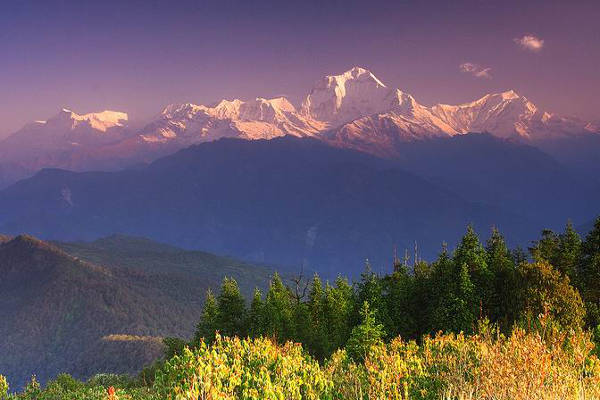
Dhaulagiri Circuit Trek
The Dhaulagiri Circuit is said by some to be the toughest three-week trek in Nepal. The bare minimum duration is 13 trekking days plus two more for acclimatisation, but most trek options are over 20 days long. This can be extended with some side trips such as the option to climb the non-technical Dhampus Peak (6,060m). Since many of the trails on the first half of the trek are rarely used, the services of a guide are highly recommended.
The Dhaulagiri Circuit takes you around the towering form of Mount Dhaulagiri (26,795 feet). Mount Dhaulagiri is the seventh-highest mountain on Earth and was first climbed in 1960. From 1808 to 1848, it was thought to be the highest, although that honour has been held by Everest since 1852.
In the extinct Indian language of Sanskrit, “dhavala” means “white” and “giri” means “mountain.” While other mountains have the same name, this particular white mountain is perhaps the most spectacular. The trek winds up through high alpine pastures, even higher passes and serene, remote valleys.
Please Note: Acute mountain sickness (AMS) is a big risk on the Dhaulagiri Trek as sudden increases in altitude cannot be avoided on this trek – the ground rises by 23,000 feet in the space of less than 20 miles.
Trekking at such an altitude is a challenge even for fit and very experienced hikers. Acclimatisation is essential, but it cannot guarantee a risk-free completion of the Dhaulagiri Trek.
Warning: Due to the altitude and remoteness, the consequences of bad weather are much more severe.
Dhaulagiri Trek Map
Dhaulagiri is northwest of Pokhara, in the Dhaulagiri region as seen in the map below.

Recommended Map
There are slim pickings for guidebooks on the Dhaulagiri Trek.
The 2001 guidebook called Trekking Everest: Base Camp, Kala Patar and Other Trekking Routes in Nepal and Tibet (2019) dedicates a chapter to the trek; however, this is a little out of date now.
There is a trekking map available here.

Dhaulagiri Circuit Route Information
Typical Itinerary
There are several Dhaulagiri Circuit trek itineraries that can be done. Below we have laid out the most popular version – 23 days, leaving from Kathmandu. If you want to make your own way to Pokhara or Beni, then you could probably organise this with your operator or guide.
Day 1
Arrive Kathmandu – a popular destination for tourists. It presents an exotic mix of Hinduism, Buddhism and western influence. Attractions include the largest Hindu shrine of Pashupatinath and the Buddhist religious monument of Nepal Boudhanath.
For things to do in Kathmandu, see best places to visit in Nepal.
Day 2
From Kathmandu, it takes half an hour to fly and seven hours to drive to Pokhara. Must-sees include the beauteous temple of Bindabasini, Davis fall, Mahendra cave, Phewa Lake, the famous Seti Gorge and the Pokhara Mountain Museum. You will spend the night in Pokhara.

Day 3
Following breakfast, it takes four hours to drive to Beni. There is a police checkpoint where your permits will be studied and verified. From this point on, nights are spent in a tented camp.
Day 4
Today, your trek begins properly. You will depart Beni for Kali Gandaki, trekking west along the northern bank of the Kyagdi Khola, through the village of Beni Mangalghat and on to Singa Bazar.
Day 5
From Singa Bazar, you will go to Takum.
Day 6
You will head north, crossing a river. The trail ascends, eventually becoming steep. It then takes you to Sibang and Mattim. Next, you will descend to the Gatti Khola before reaching Phalai Gaon (5,940 feet). From there, you will cross the Dhara Khola to emerge on Myagdi Khola’s west bank. Having climbed a ridge, you will arrive at Muri (6,070 feet), where the views of Dhaulagiri and other mountains are simply stunning.
Day 7
After descending for a short while, you will cross a stream and then terraced fields. With a ridge behind you, you will come to a pass from which Mount Ghustung South (21,210 feet) is visible. You will go down to Myagdi Khola and trek along its west bank until you arrive at the village of Naura. After that, you will ascend briefly. After crossing a grassy hill and climbing a steep slope where there are switchbacks, you will descend through a forest and then terraced fields, which brings you to Boghara (6,820 feet).
Day 8
The trail continues after Boghara. You descend through terraced fields before coming to a small ridge. Then you will enter a forest area to reach Jyardan. After that, a high, winding path spans a rocky area and goes down and then up to Lipshe, where there is no more than a single hut. The trail goes through a forest to Lapche Kharka and then rises to Dobang. The going is hard, and ropes may be needed.
Day 9
After making use of a wooden bridge at Dobang, the trail ascends, and you will find yourself among trees. The forest is beautiful and rises sharply. After traversing Myagdi Khola, you cross a stream to reach Choriban Khola. You will then reach the end of the Chhonbarban Glacier. Tukche Peak (22,430 feet) can be seen at the far end, while the imposing north face of Dhaulagiri I (26,790 feet) dominates the skyline to your right. To the West the summits of Dhaulagiris II (25,430 feet), III (25,310 feet) and V (25,000 feet) can be seen.

Day 10
This day is spent resting and acclimatising.
Day 11
Now, you will head for Midway Camp. This trail is somewhat tough, A rope will usually be used at certain points on this trail. The surroundings are quite remarkable and provide fantastic vistas of the beautiful snow-capped peaks.
Day 12
This is another rest day for acclimatisation.
Day 13
You will climb to the spectacular Classic Base Camp at 16,400 feet. This is where you will get the best views of all of the Dhaulagiri range.
Day 14
Another day of rest and acclimatisation.

Day 15
You will climb two terraced hills and then enter a valley. You will climb to the highest point of the trek – the French Col (16,730 feet), known to some as the ‘French Connection’. From there, you can see Mukut Himal (20,760 feet), Tashi Kang (20,950 feet) and Sita Chuchura (21,690 feet).
South is Tukche Peak (22,700 feet) and beyond that, the mass that is Dhaulagiri I. From French Col, the trail goes to Dhampus Pass (17,060 feet), which is the hardest portion of this trek. You will camp for the night below Dhampus Pass.
Day 16
This is a rest day, but it is possible to climb Dhampus Peak (6,060 m).
Day 17
Having climbed Dhampus Pass, you pass through slopes, which are flooded and then descend steeply to Yak Kharka. From there, you will call at Alubari.

Day 18
You will descend the breathtaking Kali Gandaki Gorge, the deepest gorge in the world. After passing the villages of Jharkot and Khingar, you will stick to the valley floor for most of the way to Jomsom. This occupies both banks of the Kali Gandaki and grants lovely views of the Nilgiri peaks. You will then trek down to Marpha, which boasts a well-planned drainage system. This is welcome refuge from the powerful winds of the area. It is well-known for its apples and their byproducts of apple cider and apple, apricot and peach alcohol.
Day 19
Your descent of the Kali Gandaki Gorge continues to Tukuche, where you come upon a large gompa – a fortified Buddhist seat of learning. Next, you will walk along the Kali Gandaki’s west bank to Larjung. You then face forests of cypress, juniper and pine as you head for Kalopani, with splendid views of Annapurna I and Fang. You will come to Lete around 20 minutes later.
Day 20
The trail descends sharply through forests to Ghasa, the southernmost extent of Tibetan Buddhism. Next comes the steepest and narrowest section of the gorge. There is a magnificent waterfall at the small town of Rupse. Next, you will next stop at Dana, from here there is a fine view of the huge peak of Annapurna South across the valley. The trail falls to Tatopani, where you absolutely must try the apple pie and hot springs!
Day 21
Not far downstream from Tatopani, you will cross the river using a large suspension bridge, putting the Kali Gandaki behind you. You will pass the villages of Sikha and Chitre and negotiate a forest that brings you to Deprali, a pass that is 9,300 feet up and provides first class vistas of Annapurna 1, Annapurn South, Dhaulagiri, Hiunchuli and Nilgiri. 10 minutes later, you will trek into the village of Ghorepani. The name means “horse water” – it was used by mules as they plied the route from Pokhara to Jomsom.
Day 22
An hour-long ascent begins before dawn, supplying intriguing views of the Annapurnas and Dhaulagiri, which glow in the morning sun from your vantage point on Poon Hill (10,570 feet). After breakfasting, you will commence the lengthy descent to Birthanti via striking oak and rhododendron forests. You will then come to the village of Ulleri and make your way up a steep staircase that feels as if it goes on forever, bringing you to Hille. You will descend inexorably to Birthanti, a short distance from the road, where a vehicle will take you back to Pokhara.
Day 23
Return to Kathmandu.

Dhaulagiri Circuit FAQ
When is the best time to trek Dhaulagiri?
The best time to trek Dhaulagiri is autumn, which is from September to November. During this time, weather conditions are mild and stable, making for slightly cool days and nights.
How much does the Dhaulagiri trek cost?
For one person, the Dhaulagiri trek can cost just under $3,000. However, if you travel in a bigger group (anywhere from 4-6 trekkers), you'll likely to get more of a discount and pay just under $2,000 per person. There are over 1000 local trekking agencies in Nepal, so make sure you pick a good, well reviewed operator.
Are permits required for the Dhaulagiri trek?
Yes, permits are required for the Dhaulagiri Circuit Trek. You will need an Annapurna Conservation Area Project Permit (ACAP) permit which costs about $30. You can pick up your permit at either the Tourist Service Centre in Kathmandu or the Tourism Office in Pokhara.
How difficult is the Dhaulagiri trek?
The Dhaulagiri Trek is a challenging hike. The trail ascends and descends through isolated areas, which can make medical assistance tricky in emergencies. Therefore, a good level of fitness is required as the trek is quite long and often steep.

Is altitude sickness a risk on the Dhaulagiri trek?
Yes, altitude sickness is a risk on the Dhaulagiri Trek as sudden increases in high-altitude cannot be avoided on this trail. It is important to have a solid understanding of the risks associated with high altitude trekking and how the body acclimatises to high altitude.

Do I need insurance for the Dhaulagiri Trek?
We recommend you get insurance for the Dhaulagiri hike. If an accident or incident should occur that requires immediate medical assistance and evacuation, you will most definitely want adequate trekking insurance that can cover the costs of air ambulance and treatment.
Make sure you have insurance that covers you for any travel related risks, like lost, stolen, damaged or delayed baggage, interruptions and flight delays and tour operators' default.
Please read our article on Nepal travel and trekking insurance as it provides great information on what type of insurance you'd need.
Continue browsing
See more information on Nepal. Or check out these other Nepal hiking articles:
